Spanish Explored Alaska in late 1700s July 25, 2011
So how is it that so many of the familiar place names in Alaska, particularly in Southern Southeast, are Spanish? Ketchikan residents live on Revillagigedo Island. Their airport is on Gravina Island. The Trans-Alaska Oil Pipeline ends in Valdez. Just down the coast is the community of Cordova. One of Alaska’s greatest glaciers is named Malaspina. West of Prince of Wales Island, there are numerous islands with Spanish names. There are two reasons. First, there were a series of Spanish voyages to Alaska in the late 1700s, but even just as important, the early English explorers were not averse with either keeping the names the Spanish had originally given many landmarks and also adding to the Alaskan map the names of Spaniards they liked or respected. Within a year of Columbus’ first voyage to the New World in 1492, Spain and Portugal signed the Treaty of Tordesillas in which they divided up the New World into “spheres of influence.” The line was roughly half way between the Portuguese Cape Verde Islands off the coast of Africa and the newly discovered Caribbean islands of Cuba and Hispanola. East of the line was Portuguese “territory,” west belonged to Spain. Of course, countries like Russia, France, the Netherlands and England were not part of the treaty, but that mattered little to Spain and Portugal. Eventually Brazil would be a Portuguese colony and much of the rest of south and central America would belong – at least for the time being – to Spain. Meanwhile, northern European countries like France, England and the Netherlands would begin to colonize North America. And Russia would begin to look east across the north Pacific to what would eventually be called Alaska. In 1513, Spanish explorer Vasco Nunez de Balboa first glimpsed the Pacific Ocean from the hills of Panama. Naturally, he immediately claimed all the land that bordered it for Spain. Little was done on the Pacific side of North America for more than two centuries. Finally toward the middle of the 1700s, Spain at last began to colonize the coast. The small west coast – now Mexican - village of San Blas – about 100 miles north of Puerto Vallarta – became the center of Spanish efforts to move north. First in 1768, Father Junipero Serra went north to begin establishing missions in what would eventually be California. The Spanish also established a navy base in San Blas that year. From that base, Spain vessels would be sent north by King Charles III several times beginning in the late mid 1770s. Spain was concerned that its territorial claims were not being accepted as the Russians began to move down the Alaskan coast and ships from other countries began to explore the west coast of North America. The first of these voyages was in 1774, when Juan Jose Perez Hernandez brought the frigate Santiago up the coast as far as the Queen Charlotte Islands and Dixon Entrance.
Alaskan historian Wallace Olson wrote in his 2002 book, “Through Spanish Eyes: Spanish Voyages to Alaska, 1774-1792” that Perez Hernandez’s goal was to travel as far north as 60 degrees latitude, which would have taken him north to near where Cordova now is, but that he became concerned about his ship’s ability to return back to San Blas because supplies were running dangerously low. In late July, they reached appoint not far from Forrester Island and the current Alaska/Canada border and then turned south. During his return trip to San Blas, Perez Hernandez parleyed with Natives in Nootka Sound on Vancouver Island, establishing a Spanish claim to the area that would be tested by England in the next two decades Since Perez Hernandez had not accomplished the primarily goal of the mission, to explore the coast to 60 degrees north, the Viceroy of New Spain, Antonio Maria de Bucareli y Ursua, authorized another voyage north. Initially, he planned to reappoint Perez Hernandez, but according to Olson, additional Spanish officers had arrived in San Blas in the interim and they outranked Perez Hernandez. The new expedition would be led by Lt. Bruno de Hezeta. Hezeta led a convoy of three ships – the Santiago, the Sonora and the San Carlos – left San Blas in March. Among the other officers involved in the voyage was Juan Francisco de la Bodega y Quadra. Perez Hernandez was second in command on the Santiago. In addition to surveying the coast for signs of Russian “encroachment,” the convoy was also instructed to go to 65 degrees north. In order to reach that point on the coast, the vessels would have had to go just north of Nome on the Bering Sea. The three ships sailed together to central California where the crew of the San Carlos was the first to enter San Francisco Bay. The other two ships continued the coast as far as Point Grenville in what is now Washington State. The crew of the Santiago was sick with scurvy and Hezeta chose to turn back for San Blas. On the way back home he would discover the mouth of the Columbia River. But the Sonoro – under the command of Bodega y Quadra - continued north and eventually reached Alaska. By August 1, they were off the coast of Baranof Island not far from present day Sitka. The reached 58 degrees latitude and then entered Sitka Sound. Inside the sound, they named a large, well formed volcano “San Francisco.” The mountain was later referred to as “San Jacinto.” In 1778, English Captain James Cook dubbed it “Mount Edgecumbe.” Also faced with a crew suffering from scurvy, Bodega y Quadra chose to head south. On the way home, they explored an area west of Prince of Wales Island on August 24th and named it Bucarelli Bay, after the viceroy. “The bay is so delightful for the mildness of the climate for the calmness of the sea, for the water in rills and reservoirs formed by Nature, and the good bottom and the fish that are in it that undoubtedly I would have stayed several more days had the season not been so advanced,” Bodega y Quadra wrote in his log, as quoted by Olson. The Sonora continued on to San Blas. In 1778, English Captain James Cook sailed the Alaskan coast and when the Spanish found out, they ordered another voyage north in hopes of catching him in Spanish “territory.” Cook – on his third voyage to the Pacific – had already “discovered” the Hawaiian Islands before turning north to seek the western terminus of the fabled Northwest Passage. He reached North America on the Oregon Coast and – like the Spanish before him – traded with the Natives in Nootka Sound on Vancouver Island. He then continued north, all the way to the Bering Strait, “discovering” Cook Inlet and mapping much of the Alaskan coast in the process. He did not – however – find the Northwest Passage. Continuing back to Hawaii, he was eventually killed there in a skirmish with Natives. When word of Cook’s voyage to find the Northwest Passage reached the Spaniards in 1778, they put together a third voyage to Alaska to reassert their claims and to try to catch Cook on Spanish territory. The 1779 voyage was led by Ignacio de Arteaga and consisted of two small war ships or corvettes, the Favorita (commanded by Arteaga ) and the Princesa (commanded by Bodga y Quadra). They failed to catch Cook and they also did not meet up with any Russians, but they did explore much of the coast all the way to Cook Inlet and the Kenai Peninsula – where they performed a “possession ceremony” near modern day Port Chatham. Then – plagued by scurvy once again – they headed back to San Blas.
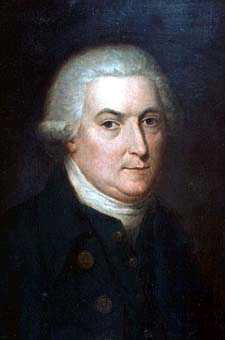
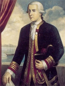
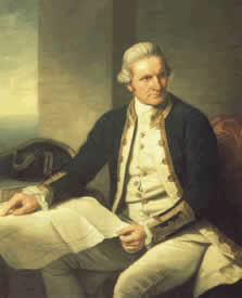
After the 1779 voyage, nearly a decade would pass before the Spanish returned to Alaska. The primary reason was the Spain was embroiled in the war that led to the United States independence and it was not focused on further exploration until treaties were signed in 1783-84 to end that war. In March of 1788, Esteban Jose Martinez on the Princesa and Gonzales Lopez de Haro on the San Carlos headed north, reaching Montague Island in May. In June they reached Kodiak Island and made contact with the Russians at Three Saints Bay. In discussions with the Russians, they learned that Russia intended to eventually set up more settlements down the coast as far south as Nootka Sound. The Spanish continued west to Unalaska before returning to San Blas in December. Concerned that the Russians planned to move down the coast, Spanish authorities immediately dispatched another mission north, once again led by Martinez and de Haro. By the summer of 1789, the Spanish were at work developing a settlement at Nootka Sound on West Vancouver Island. They also did some exploring in the area, finding and naming the Strait of Juan de Fuca in the process as well as Lopez Island and Haro Strait north of Puget Sound. By 1790, the base was firmly established . And several voyages were made north. In 1790, Salvador Fidalgo took the San Carlos as far Kodiak Island. On the way, he asserted Spanish sovereignty at several locations, most notably Port Valdez and Cordova Bay and the Kenai Peninsula south of modern day Anchorage. Valdez and Cordova would henceforth retain their Spanish names. In general, the Russians ignored the Spanish incursion. In 1789, the King of Spain sent Alessandro Malaspina on a round the world voyage of exploration with the warships Desubierta and Atrevida . As part of that voyage they were to explore the Northwest Coast in search of the fabled Northwest Passage. They reached the Alaska Coast in 1791 and spent some time exploring between Yakutat and Prince William Sound. They did not find the Northwest Passage but artists and other scholars on the ships made a study of the Tlingits, one of the first to record social mores, language, economy, warfare methods and burial practices. In the meantime, Spanish occupation of Nootka Sound was pushing England and Spain – already ill at ease because of the recent war – on a course toward another one. Fortunately for both countries, the men they chose to sort it out were Bodega y Quadra and Captain George Vancouver.
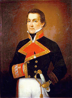
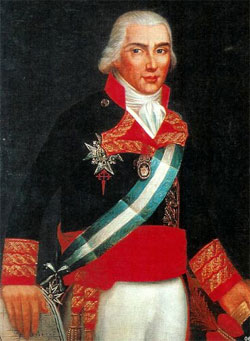
Starting in 1790, the two men met and concluded three agreements that sorted through the territorial claims of Spain (going back to the Treaty of Tordesillas) and England (beginning with the voyages of Captain Cook). In some ways, both countries were operating from positions of weakness due to the recent war and neither was in a strong position to press all its claims. As further agreements were signed it became clear that Spain’s interests lay further south on the continent and that England would have its hands full staking its claim to the Pacific Coast with both Russia and the fledgling United States looking to establish presences in the Pacific Northwest and Southeastern Alaska. By the mid 1790s, Spain had withdrawn its settlement from Nootka Sound while Vancouver had undertaken several voyages to Alaska that had surveyed – and named – hundreds of miles of new territory. The English also agreed to not establish a permanent presence at Nootka Sound. In 1792, there was one last Spanish voyage north of Puget Sound. Don Jacinto Caamano in command of the Aranzazu sailed north to Bucarelli Bay. While much of the outer coast had been explored, he concentrated on some of the inner channels. He sailed Clarence Strait as far north as what is now called Point Caamano on the southern tip of the Cleveland Peninsula. He named Revillagigedo Channel and Boca de Quadra. Caamano was also responsible for many of the Spanish place names west of Prince of Wales Island. According to former Ketchikan author Lonnie Haughton, the names the Spanish bestowed in that area show the “trials and tribulations of exploration 200 years ago.” “Puerto de los Dolores named for the word for ‘sorrows,’ Haughton wrote in the Alaska Fisherman’s Journal in April of 1987. “Cabo Amargura for the word for ‘bitterness,’ Punta de Castigo (Punishment Point), Isla Triste from the word for ‘sad.’” Although the first mariner to chart Gravina Island was Caamano in 1792, he did not name it on his charts (which also concluded that what are now Gravina and Annette islands were a single island). It was Capt. Vancouver who named Gravina, after Frederico Gravina, a prominent Spanish naval officer of the time, during his explorations that lasted from 1791 to 1795. Caamano, who named the point at the tip of the Cleveland Peninsula after himself because that was the point he turned around at, had named a large channel just north of the Canadian border for Don Juan Vicente de Guemes Pacheco de Pedilla y Horcasitas, also known as the Count of Revillagigedo and the Viceroy of New Spain. Pedilla y Horcasitas was a strong supporter of the voyages to Alaska to spread the Spanish influence up the coast, according to Dr. Arsenio Rey-Tejerina, a former University of Alaska-Anchorage professor who has written frequently about the Spanish exploration of Alaska. “Because of his energy and intelligence, he won the admiration of all who knew him,” Tejerino wrote in 1987, in the Southeastern Log. “Mexican historians have judged him as one of the best of the viceroys (of New Spain).” After exploring the large island between Gravina and the mainland, Vancouver also named it after Revillagedo. Vancouver clearly respected the efforts of his Spanish counterparts to explore the Northwest Coast. For his good friend, Bodega y Quadra he originally named Vancouver Island, Vancouver’s and Quadra’s Island. He named several Alaskan landmarks after the Spaniards such as Point Alava after the Spanish Governor at Nootka. Even some non-Spanish sounding locations actually had Spanish connections. Point Higgins sounds like a good old fashioned English name. Vancouver actually named it after the President of Chili, Higgins de Vallenar, whose last name was also appended to the northern tip of Gravina Island.
Contact Dave at dave@sitnews.us
Publish A Letter in SitNews Read Letters/Opinions
|
||||||