
Ketchikan's Iconic Tunnel Turns 60
By DAVE KIFFER
June 17, 2014
Tuesday PM
Ketchikan, Alaska - To some Ketchikan’s downtown tunnel seems redundant.
After all, according to a “Ripley’s Believe it or Not” newspaper column in 1967, it was the only tunnel in the world that could be driven “over, around and through.” It could also be walked under at one point via a cramped catwalk that was submerged at high tide.
To others, the tunnel is representative of Ketchikan’s biggest boom times. A point in the mid 1950s when Ketchikan Pulp Company built one of the world’s largest pulp mills and the town population doubled in a few years. The tunnel was part of a large infrastructure boom intended to meet that growth.
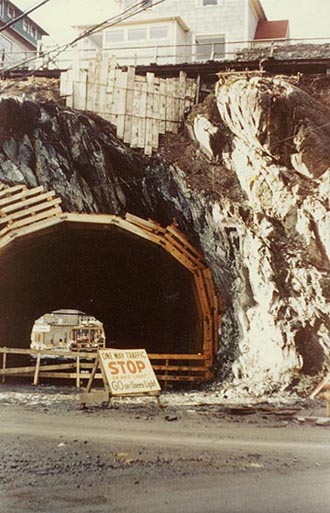
South portal of the Tunnel during construction, 1953
Donor: Evelyn Valentine, THS 80.9.5.10
Photo Courtesy Ketchikan Museums
SitNews file copy 2003
|
In the late 1940s, Ketchikan was in the economic doldrums. The salmon canning industry was rapidly shrinking as demand for product was decreasing and the once endless salmon runs were falling off because of the overuse of fish traps.
There had been talk of a timber industry in the Tongass National Forest for decades, but it was just talk until two large corporations signed 50 year contracts to harvest timber from the national forest. Most of that harvest would go toward the operation of two pulp mills, one of which would be located six miles north of Ketchikan at Ward Cove.
At the time, Ketchikan’s infrastructure had changed little from the 1920s, a time when there were fewer and much smaller automobiles. But with Ketchikan faced with more than 1,000 workers in town to build the mill and a likely year round mill employment of 500 to 700 workers, it was clear that the community was facing significant change.
Some of that came in new housing as four large apartment buildings, including two 11 story ones in Ketchikan’s West End, were built. New neighborhoods were also developed in such areas as upper Carlanna Creek and the Heath Addition, where Ketchikan’s First through Seventh Avenues now are.
New roads were also needed throughout the community and the federal government began expanding the highways to the north and south of the city of Ketchikan.
One of the biggest transportation bottlenecks in the community remained the narrow wooden road that connected downtown Ketchikan with its first “suburb” Newtown.
Newtown had begun developing in the late 1890s as developable land in the downtown was rare. By 1900, when Ketchikan incorporated as a city, there were several businesses and numerous houses located north of the large promontory that marked the edge of downtown Ketchikan at the corner of Front and Grant streets.
In 1902, the Ketchikan town council approved a $1,210 contract for a 1,200 foot long, 10 foot wide walkway around the bluff, connecting downtown and North Ketchikan as it was sometimes called. By 1910, the walkway had been widened to 20 feet to accommodate some of the trams that were being used to move larger objects around the community. By the mid 1910s, the first small automobiles were using the wider “street” to go back and forth between the two areas. Over time, the roadway was eventually widened to 30 feet, but the rapidly increasing water depth in that part of Tongass Narrows made further expansion expensive and difficult.
By early 1950, it was clear that the Ward Cove pulp mill was going to be developed and local officials with the help of federal highway engineers began to look at the improvements Ketchikan would need.
One of the persistent rumors about the development of the tunnel was that the tunnel was built simply because many of Ketchikan’s “movers and shakers” lived on “Nobb Hill” on the bluff and refused to let the government simply blast out the entire hillside as happened elsewhere in the community.
If that rumor is true, then the issue had been decided by 1950 when the city records first show reports discussing a “tunnel.” All of the city reports from that era indicate that a tunnel had been considered for some time. None indicated any proposals whatsoever to blast out the entire promontory.
Another common current modern rumor is that the tunnel construction was delayed for months, even years, because residents who were having their property either destroyed or altered by the projects sued the federal government and won significant amounts of money.
The records of the construction project, currently in several boxes at the Tongass Historical Museum, paint a different picture. While there were significant negotiations between the project and the affected property owners, those negotiations apparently did little to alter the time frame of the design and construction of the tunnel.
Most of the lawsuits were settled after the construction was completed, some as late as 1957 and 1959. And the amounts of most of those settlements were generally only a fraction of the project costs. Ketchikan was simply a less litigious society in those days.
Although the tunnel project went from design to construction in just slightly over four years, it was the most contentious part of the pulp mill infrastructure improvements.
While there was general agreement in the community about the need to expand the roads and improve traffic flow to the north end of the community, as usual the city’s two newspapers publically disagreed on the need for a tunnel.
The Ketchikan Chronicle, run by Bill Baker, promoted the tunnel as sign that Ketchikan was becoming more of a “big city.” The Ketchikan Daily News, run by Sid Charles, felt that the tunnel was an expensive, unneeded boondoggle. The Daily News supported a bypass road that would be located along the hillside from Downtown Ketchikan to Newtown.
That bypass route was considered by the Ketchikan City Council when it began considering options for ending the “bottleneck” on Water Street between Downtown and Newtown.
The initial engineering report, finished in March of 1951 dismissed the bypass road.
“The route of the proposed improvements from Front and Grant near City Hall to the northern city limits (then around what is now Washington Street) constitutes the main and only practically feasible route,” the report concluded. “The conspicuously rough and rocky configuration of the surface (of the hillside) with in city limits would lead to great expense.”
The 1951 report also assessed the idea of expanding the Water Street boardwalk seaward.
The water was simply too deep and that “presents a difficult and expensive situation as far as widening” into a two lane road. But a water arterial for one way traffic would have to be part of the solution because it was not feasible to build a two lane tunnel road through the bluff.
Therefore, the report concluded, although a tunnel would be expensive and difficult to construct it would be cheaper in the long run than attempting either a wider arterial around the outside of the bluff or a two lane road farther up on the hillside, most likely from the top of Front Street to the north.
The 1951 estimate of the total project costs were more than $1.2 million, with the tunnel excavation and roadwork taking up slightly more than $370,000. In addition to the tunnel construction the project would include a rebuilding and widening of Water Street around the tunnel area to accommodate one-way traffic. But the most expensive part would to relocate several properties and dramatically widen Water Street between the new tunnel and the area around the Lutheran Church.
By the time construction was set to commence in 1953, the highway department of the Department of the Interior estimated the total project cost at $1.75 million and the tunnel work at just over $500,000.
According to the construction documents, the rock to be tunneled through was made up of “greenstone lava flows, interstratified with volcanic tufts and black slate.”
The construction documents also noted that blasting should take place in “conditions that prevent damage to neighboring structures.”
The documents also called for timbers and matting to be placed in such away as to contain the blasts.
Canadian firm Northwood Construction was selected to build the 273 foot long, 19 foot high tunnel.
The first order of business was to demolish the Dickenson Building which was located on the end of Front Street, right where the south end of the tunnel would. Construction began on Aug. 15 and the first blast on Aug. 20, 1953.
Barely a week later another blast on Aug. 27 destroyed a nearby utility pole on Water Street, cutting off power to Newtown and blocking traffic for several hours.
But that paled in comparison to another blast on October 2, 1953. The headline in the Ketchikan Chronicle was “Big blast blows rocks thru roof; Blacks out town.”
“The blast that sounded like a July 4 rocket exploded in a series of pops was an extra heavy load of dynamite at the Water Street tunnel at 9 to 9 last night, and it blew rocks through the roof of Bucey Motor company and Ketchikan Air Service, whiole blacking out residential and some business spots until 2 a.m,” the Chronicle reported. “The mat that covers the tunnel and hillside, weighing about a ton, took off over the street, falling onto power lines and shorting out primary lines. The fire alarm circuit also went out for a time. The radio on K.A.S. went down too.”
No other significant blasts were reported for the next few months in either the Daily News nor the Chronicle, so apparently those blasts caused more limited collateral damage.
In late November, the Daily News reported that a special “jumbo” drill was being used to core out the “Waterfrong Highway Tunnel.”
A positive side effect of the drilling was the creation of fill that could be used for other projects in the aggregate poor town. Former Ketchikan resident Pat Moore says her husband Des used to haul away excess rock from the site for other projects in the community.
On February 16, 1954 at 3:15 pm the tunnel was officially “holed” through and the Daily News celebrated with a photo of several people looking through from the north end of the tunnel. They could reportedly see the Eagles building (now the Masonic Lodge) on the other side of the tunnel.
Even before the tunnel was built, work began, in July of 1953, on the arterial around the outside of the tunnel was being worked on and Water Street in Newtown was also being expanded with several businesses and non commercial properties being affected. Birch, Lytle and Green of Seattle was the successful bidder on that portion of the project at slightly more than $1.6 million.
Two properties, 1452 Tongass Avenue and 907 Water Street were completely demolished.
Most notably, the widening of Water Street caused the community civic center, located next to city float, to be halved in size and the winding stairway to the Zimmerman House also was also a construction casualty. The Gaffney Store was relocated from Newtown to Downtown.
Several buildings were moved back to widen Water Street including the Traversy House, Traversy General Store, and Northern Machine Works.
The 60 by 85 foot Nordby marine supply store was moved 29 feet into the City Float area.
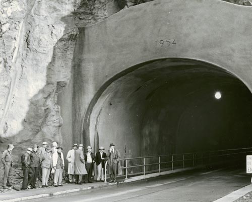
North portal of the new Ketchikan Tunnel, 1954
Photographer: Paulu Toivo Saari
Donor: City of Ketchikan, THS 80.1.5.137
Photo courtesy Ketchikan Museums
Sitnews file copy 2003
The Ketchikan Daily News called it “one of the largest building moving jobs ever undertaken in Ketchikan.” The building was moved back in three sections and then reconstructed on pilings.
Another sidelight to the road project north of the "tunnel" were efforts to bridge the construction zone. A pathway was built from upper Front Street around the zone for pedestrian traffic. And boats were used to ferry such items as groceries and mail between the two temporarily disconnected parts of the community.
By November 23, 1954 the tunnel was complete for vehicle and pedestrian access. Sid Charles at the Daily News could not resist one final “swipe” at the project.
His “Observations at Random” column reported that “Captain Tom Smith, a visitor just down from Juneau, said that he is surprised at the length of the tunnel. ‘As a result of all that I’d heard in Juneau about the tunnel, I thought it must be at least a mile long. Heck I see it’s nothing but a gopher hole.’ “
Ketchikan’s tunnel almost immediately became known for the ability for residents to go over it (to reach the houses on Nob Hill), around it (heading south into Downtown) and through it (heading north toward Newtown and the West End).
Of course, it also became on object of interest and curiosity for other reasons. Almost immediately, Ketchikan’s residents learned that it was a 273 foot long megaphone.
Groups of children would scream as they walked through it, much to the dismay of nearby residents and business.
Older children, teenagers, would soon discover that revving one’s car engines in the tunnel would cause windows to rattle quite a distance away.
Even 60 years later, one can still hear screams and car engines echoing from the tunnel at any hour of the day.
Also in the early days fire crackers tossed inside the tunnel would also cause nerve jarring blasts throughout the downtown area.
Some were even more creative in their use of the tunnel. Patrons at nearby bars would set up impromptu bowling lanes in the tunnel late at night, according to old timers. There were also wheel and inner tube rolling contests.
Eventually, engineers and unlimited federal highway money would create the alternative routes from Downtown to the rest of the community. The Schoenbar bypass and Third Avenue bypass were marvels of engineering and money. The Third Avenue bypass cost more than $20 million for a single mile of roadway connecting Bear Valley with the West End briefly making it the most expensive mile of roadway in the country.
But Ketchikan’s “over, around and through” tunnel still remains the primary arterial connecting downtown Ketchikan with its northern environs. Even at 60 years old and in need of a facelift, it remains one of Ketchikan’s most photographed community icons.
Related:
KETCHIKAN'S UNIQUE TUNNEL; The when, where and why of it By JUNE ALLEN - It's an honest question: "Why does Ketchikan have a tunnel that has a street running around the side of it? And houses on top of it?" - More...
SitNews - April 09, 2003
On the Web:
Columns by Dave Kiffer
Historical Feature Stories by Dave Kiffer
Dave Kiffer is a freelance
writer living in Ketchikan, Alaska.
Contact Dave at dave@sitnews.us
Dave Kiffer ©2014
E-mail your news &
photos to editor@sitnews.us
Publish A Letter in SitNews Read Letters/Opinions
Contact the Editor
SitNews ©2014
Stories In The News
Ketchikan, Alaska
|
Articles &
photographs that appear in SitNews may be protected by copyright
and may not be reprinted without written permission from and
payment of any required fees to the proper sources.
|
|