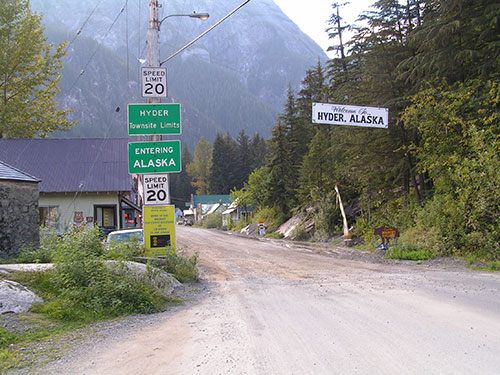
Hyder border crossing debate: Is Canada still miffed over 1903 decision?By DAVE KIFFER April 06, 2015
Depends on who you ask. Hyder has always been an official part of Alaska, but it also completely isolated by geography from the rest of the state. And the current debate about whether to keep open a 24-hour-a-day border crossing wouldn't even be taking place if Canada had been successful with its border proposal in 1903.
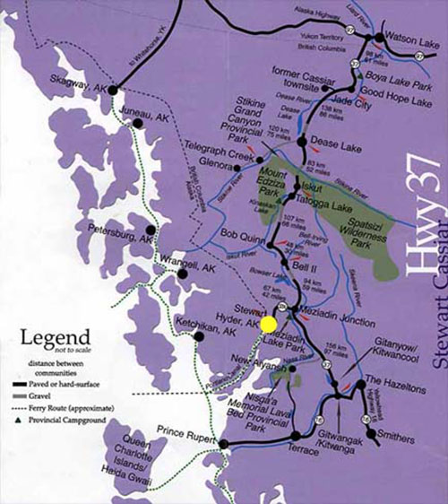
The border between Stewart, British Columbia and Hyder, It was also the case that the most used access points to the Klondike had to pass through American territory in Alaska. Canadian overland routes to the Klondike had proved to be too difficult and Canadians sought an “all Canada” route that used the Inside Passage. But how far Russian Alaska territory - which was ceded to the United States in 1867 - extended inland was unclear. Canada – seeking access to freshwater ports in the region - convinced England to negotiate more specific boundaries with the United States and that led to the 1903 Boundary Commission which was comprised of representatives of the United States, Canada and Great Britain. Under that proposal, most of the towns in Southeast Alaska, including Skagway, Juneau, Wrangell and Ketchikan, would become Canadian. That proposal was rejected by the panel. Canada then returned to the table with a modified proposal in which the border would follow the mainland coast range as far as the Stikine River and then dog leg into Sumner Strait and follow Clarence Strait to the border. Everything inland (which would include the Cleveland Peninsula, Revillagigedo Island and the mainland that is now Misty Fjords) would have become Canadian territory, as would all land below the 54.40 latitude Historians generally believe that the British member of the panel, Lord Alverstone, received instructions from his government to support the American position because Great Britain was looking for a favorable American response on other issues. Later Canadian historians have generally agreed that the final boundary was probably the correct one, but at the time of the decision anger in Canada was such that the young Confederation began moving toward promoting Canadian nationalism as opposed to Canada remaining a more subservient member of the British Empire. The general feeling in Canada was that Great Britain looked after its own interests and betrayed Canada. The boundary was instead drawn down the center of 90 mile long Portland Canal from the small mining communities of Stewart and Hyder to Dixon Entrance. At Dixon Entrance, everyone agreed the boundary would be drawn across Dixon Entrance, but even that decision retains some contention, with Canadian officials contending the border follows the 54.40 latitude and actually cuts the tip off Alaska's Dahl Island at Cape Muzon. Alaskan officials contend the actual border is further south, offshore in Dixon Entrance.
Location of Hyder (Yellow dot) - US Border small black ----
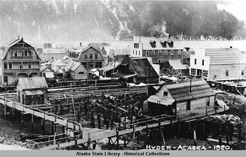
Canadian historian Murray Lundberg writes that the first group of prospectors arrived in the area from Seattle. On May 4, 1898, 64 men came chasing rumors of gold. “Although this group of prospectors was only mildly successful, the first gold claims were staked in 1899,” Lundberg wrote on the Explore North website in 2013. “The number of prospectors working along the canal grew each year.” Lundberg notes that the provincial government felt the geological formations in the area were “exceptionally favorable” for mining. Ironically, many of the larger deposits would turn out be on Canadian territory on the upper Salmon River that could only be accessed through the American territory at Hyder. During World War I, the prospectors on the American side of the border applied to the U.S. government for a post office to be called Portland City. The government denied the request, saying that it already had too many communities named some variation of Portland. The residents then suggested naming the community after a respected Canadian mining engineer, Frederick Hyder. Hyder was well known for predicting a prosperous future for the area because of its mineralogy. Hyder’s full time population peaked at 254 people in 1930, but it had fallen to only 30 by 1950 as most of the mines struggled and closed. Only the Granduc and Premier, on the Canadian side, stayed strong in those years. At one time, the Premier was one of the largest gold mines in the world, according to Lundberg.
Hyder, Alaska 1920 In the 1920s and 1930s many of Hyder’s buildings were on pilings stretching out hundreds of yards to deeper water over the tide flats. The town had four hotels, numerous bars and stores, pool houses and bath houses which were abandoned as the mines dried up and the town withered away. Many of the docks and the remaining buildings were destroyed in a large fire in 1948. Hyder’s population has risen somewhat in recent decades generally ranging between 80 and 120 depending on the time of year. By the 1960s, Hyder was trying to market itself to visitors as the "Friendliest Ghost Town in Alaska." Several attempts were made to boost tourism business and to connect the community with the rest of Alaska. From the early 1980s to the early 1990s, the Alaska Marine Highway System provided once a week ferry service, stopping at the Stewart Dock. Several air taxi operations also provided regular service between Ketchikan and Hyder/Stewart. There have also been other attempts to bring economic development to the area in 2001, a company called Alaska Chill announced it was going to work with the Hyder Community Association to set up a 73,000 square foot bottled water plant and market Hyder water nationally as Alaska Glacier Blue. Alaska Chill announced that it would employ 40 people at the plant. But those efforts came to naught. Approximately 60,000 visitors came to Hyder in the 1980s, primarily via the road connection. Today, the state of Alaska estimates that between 75,000 and 80,000 visitors come to upper Portland Canal each year. Many of those people make their way to the Glacier Inn where they can be officially “Hyderized” which involves a shot glass of 190 proof Everclear grain alcohol.
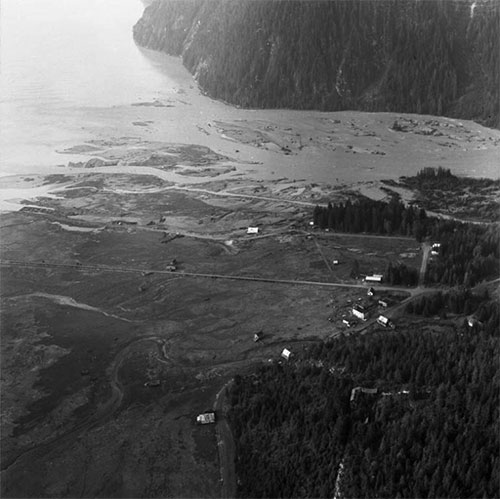
Hyder - Sept. 16, 1967 Since the 1980s, the area has benefited by several movie shoots. Most notably a 1982 remake of “The Thing” was filmed at the Granduc Mine. The Hyder area was specifically chosen for this film (which was set in Antarctica) because the area gets upward of 250 inches of snow each winter and has been known to get up to 1,000 inches in particularly snowy seasons. In 2002, the Robin Williams/Robert DiNiro movie “Insomnia” was partially filmed in Hyder and Stewart. Traditionally, Hyder’s remaining bars have had a built in late night clientele as bars on the Canadian side of the border have tended to close earlier. How the closing of the border between midnight and 8 am will affect those visits is unclear. In the last decade, Hyder has become a favorite stop on long distance motorcycle rides and events, such as a variety of national “Iron Butt” contests that involve visiting as many states as possible during a short time span. For example, Hyder has been the location of an event called the Hyder Seek, which is a gathering of long distance motorcycle riders who travel from all over North America and arrive in Hyder on Memorial Day weekend. In 1998 author Ron Ayres set a record of riding to the contiguous 48 states in six days. Ayres went on to add to the 48 state record by continuing on to Hyder, to establish a new 49-state record of 7 days, 0 hours and 20 minutes. Ayres named the new long distance ride the "48 Plus." The state of Alaska model borough boundary originally suggested that Hyder be part of an expanded Ketchikan Gateway Borough. There was also study about whether it could be part of a newly created Wrangell Borough. Hyder residents made it clear that from their point of view they preferred to not be part of any borough, but if forced to join one they would prefer to be in a Prince of Wales Island borough if that was ever created. The Ketchikan Gateway Borough eventually expanded to include nearly all of the mainland territory from Ketchikan south to the Canadian border. But Hyder was left out of that expansion and currently remains part of the greater state unorganized borough.
On the Web:
Contact Dave at dave@sitnews.us
Publish A Letter in SitNews Read Letters/Opinions
|
||