When "54-40 or Fight" Was the Presidential CryBy DAVE KIFFER January 12, 2022
Well, not really Southeast Alaska. The eyes were toward the boundary of Russian America and the "Oregon Territory." And, actually, most of the eyes were on Texas, but the election slogan of Democratic candidate James Polk of Tennessee was “54-40 or fight.” Which, as all cartographers know, is the latitude that runs roughly through the center of Dixon Entrance. Confused? It all goes back to “Manifest Destiny.”
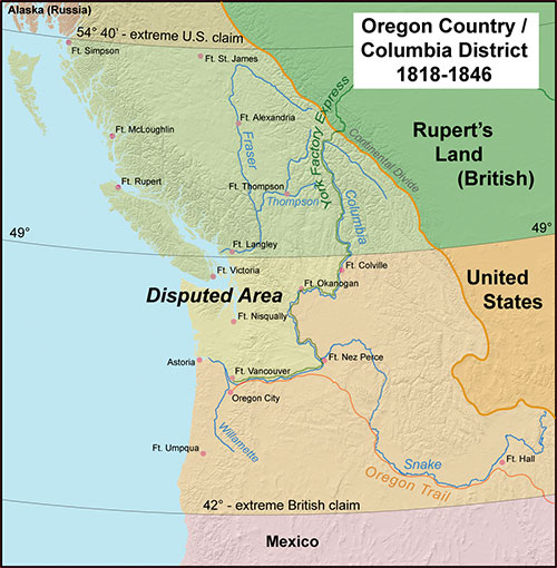
In 1844, the idea that America should expand to “from sea to shining sea” was a popular one in the half-century-old republic. Those in the South favored the annexation of Texas, which had been “independent” from Mexico since 1836. Southerners saw the annexation as a way to add political power to the pro-slavery side in the debate that was fracturing America into north and south. That annexation would eventually bring the US into conflict with Mexico and allow further American expansion into the Southwest by the end of the decade. In order to counter “expansion” in the South, Northerners favored resolving the long running dispute between the United States and Great Britain over the “Oregon Territories” and then creating “states” in that region that would be non-slave states The north Pacific coasts of what are now Washington, Oregon and British Columbia had always been in contention. At one point, they were claimed by Russia, Great Britain, the United States and Spain. Even the French had their eye on the area at one point. After the War of 1812, control of the Oregon “territories” was shared, suspiciously, by the United States and Great Britain. The only thing the two sides generally agreed on was that the territory south of the Columbia River belonged to the United States and the territory north of Puget Sound belonged to the British. British Territory ended where Russian America began, at 54 degrees, 40 minutes north latitude, as established in the Russo-British treaty of 1825. At to the territory in the middle, which was what is now much of Washington state, the relationship would remain “complicated” until the mid-1840s. Between the 1810s and the 1840s, as Americans poured into the Oregon Territory, there were numerous disputes which led the British to suggest they should control the territory all the way down to the Spanish border in Northern California and also led the Americans to suggest they should control “Oregon” all the way north to the Russian border at 54’ 40.” Polk’s opponent in the 1844 election was Henry Clay of the Whig Party. The Whigs had partially risen from the defunct Federalist party earlier in the century, but were also a conglomeration of several smaller parties. As a result, Whig policies were often crafted to meet a variety of interests. The Whigs were not opposed to manifest destiny, but they were not strongly in favor of it either.
The Democratic party, then the dominant party in the country, was strongly in support of Manifest Destiny, especially when it came to Texas and other slavery supporting areas of the Southwest. If the Oregon Territories had to be developed and more non-slave states also added, that was just the cost of doing business. The Polk Campaign quickly latched onto the Oregon Territory slogan of “54-40 or fight,” suggesting that if Great Britain didn’t concede the entire coast between Russian America and Northern California to the United States, America should take it. Since there was still residual anger in the country from the British invasion during the War of 1812, it was a popular platform, even though it could clearly have led to a challenging two-front war, as Mexico was opposing US efforts to annex Texas. In the end, Polk was victorious but by a very narrow popular vote margin. Then the outgoing President John Tyler stole some of Polk’s thunder by completing negotiations to annex Texas, just before leaving office. Once in office, Polk was left dealing with the fallout of his slogan and many in the country expected him to demand “54 40 or fight” from the British. He did neither. By 1846, he had concluded a new treaty with Great Britain that split the coastal territory at the 49th parallel, which meant that Puget Sound would be under American control and the area that would be Vancouver to the north would belong to Britain. The border was wiggled a bit to keep all of Vancouver Island together, but generally the 49th parallel would be the US-Canada border moving on. Polk did eventually succeed into leading the United States into a war with Mexico that led to Arizona, New Mexico, southern Colorado and California becoming part of the growing country. But soon “54’ 40” or Fight” disappeared into the fog of American history. In 1867, Russia sold Alaska to the United States and some in America began agitating for the US to acquire British Columbia as well. BC was generally cut off from the rest of Canadian mainland by the Rocky Mountains and even some residents of BC pushed to join America. Many in the American northwest wanted to see American “territory” stretching from Southern California to the Arctic Circle. It was only after the Canadian government agreed to connect BC to the rest of the country via a railroad through that the territory agreed to become a Province in 1871. The Canadian Railroad finally reached Vancouver in 1886, bringing a stop to American Manifest Destiny at the 49th and 54th parallels, at least on the North American continent.
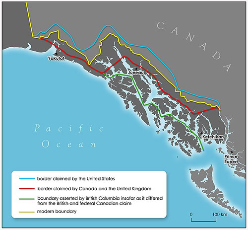
Editor's Note: The Alaska boundary dispute was a territorial dispute later between the United States and the United Kingdom, which then controlled Canada's foreign relations. It was resolved by arbitration in 1903. The dispute had existed between the Russian Empire and Britain since 1821, and was inherited by the United States as a consequence of the Alaska Purchase in 1867. The final resolution favored the American position, as Canada did not get an all-Canadian outlet from the Yukon gold fields to the sea. The disappointment and anger in Canada was directed less at the United States, and more at the British government for betraying Canadian interests in favor of healthier Anglo-American relations
On the Web:
|
||||||