January 26, 2005
Fairweather, named after Mt. Fairweather in Alaska's Glacier Bay National Park, was first launched in 1967. The ship spent almost every summer surveying in Alaska waters from Ketchikan in southeast Alaska to Shelikof Strait along the southern Alaska peninsula. Because of budget cutbacks, Fairweather was deactivated in 1988. It was later briefly reactivated in 1989 to conduct damage assessments in Prince William Sound after the disastrous Exxon Valdez oil spill. After that, for 15 years the ship was docked at the NOAA Marine Operations Center-Pacific in Seattle, Washington. 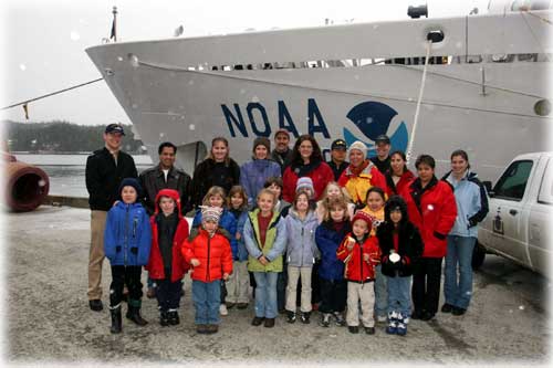 Back row parents and crew: LTjg Mark Van Waes, Danilo Gonzales, Jessica Mathews, Diana Maioriello, John Krosse, Brenda Souza-teacher, ENS Tri Nguyen, Connie Stewart, ENS Abigail Higgins, Kathy Fast, Erlinda Gonzales, Surveryor ST Jennifer Keene. Photo by Carl Thompson ©2005
Alaska's coastal waters are increasingly transited by large cruise liners, cargo ships and oil tankers, yet many of the seafloor surveys of areas outside primary shipping lanes were done decades ago using technology that did not provide full bottom coverage. Changes due to receding glaciers, storms, shipwrecks and other hazards also can make more recent surveys obsolete. Home ported in Ketchikan, Fairweather has been equipped with the latest multibeam echo sounder technology, and state-of-the-art side scan sonar will be added next year. The ship will be able to map 100 percent of the ocean bottom, determine bottom characteristics and identify areas of interest to navigators, biologists and geologists.  Photo by Carl Thompson©2005
In addition to the work to reduce Alaska's 9,700 square nautical miles of critical survey area backlog, Fairweather has other missions. The Fairweather is capable of conducting essential fish habitat surveys that are required to make science-based decisions about uses of fisheries resources. The NOAA fleet of research
and survey ships and aircraft is operated, managed and maintained
by NOAA Marine and Aviation Operations. NMAO includes commissioned
officers of the NOAA Corps and civilians. The NOAA Corps is the
nation's seventh uniformed service, and, as part of NOAA, is
under the U.S. Department of Commerce. The Corps is composed
of officers - all scientists or engineers - who provide NOAA
with an important blend of operational, management and technical
skills that support the agency's environmental programs at sea,
in the air and ashore.
Carl's Alaska Photos Web Site Publish a Letter Read Letters Submit an Opinion - Letter Stories In The News Ketchikan, Alaska |