 Newtown, Over A Century Old By DAVE KIFFER August 18, 2005
Most of the people living in Ketchikan were there because of the nearby salmon stream or because there were numerous small mines in the area. 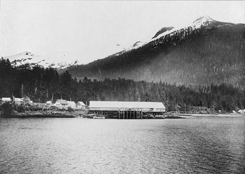 Forms part of: Frank and Frances Carpenter collection (Library of Congress). Gift; Mrs. W. Chapin Huntington; 1951. Photograph courtesy Library of Congress
By 1898, the available land around the Creek mouth was gone and the town began to spread northward. History has lost track of the first Ketchikan resident to locate north of the bluff that now holds Ketchikan's famous tunnel. But photos from 1900 show cabins and stores already sprouting in the area that it now called Newtown. Local historian June Allen believes that the first cabins were built in Newtown in 1898.  Photo courtesy David Kiffer
State historian Rolfe Buzzell - who evaluated historic properties in the Newtown area for the State DOT in 1991 - puts the date for the beginning of the development of Newtown at a little later. "By 1900, the downtown area of Ketchikan had filled up and the community began spilling north around the bluff into what residents called Newtown," Buzzell wrote. One of the earliest people to see the value of expanding into Newtown was James W. Young. Young was the brother of well-known Presbyterian missionary S. Hall Young and had first come to Saxman in 1895 to be the teacher at the new school in the community 2 miles south of Ketchikan. 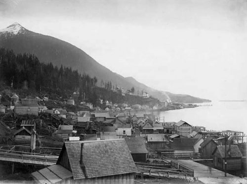 Photographer: Harriet Hunt; Donor: Forest J. Hunt Photograph courtesy Tongass Historical Museum
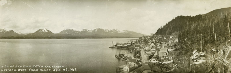
"It wasn't long however, until James relocated in the section of Ketchikan known as Newtown which is about eight blocks north of downtown," Braithwaite wrote. "The shelf of level land upon which Newtown is located is so narrow that it disappears at points where rock heads jut out into the bay. There is so little land between meander line and mountain that pilings had to be sunk here, too, to support the buildings." Photos from 1900 to 1903, show Young's distinctive white two story store towering over many of the smaller cabins and shacks in the area. The building - now the First City Saloon - remains in Newtown to this day but has been extensively remodeled over the years. The Ketchikan Historic Properties survey of 1984 indicates that the building was likely the first commercial building in Newtown. Braithwaite believes that the store was actually built in Ward Cove and then floated down to the Newtown. She wrote that the former owners of the building, the Cullop family, believe the building was built elsewhere. Braithwaite says that Idah Young's brother, Charles Sparhawk was living and clerking at a store in Revilla - a small settlement on the east side of Ward Cove before 1900. "Perhaps the store where Charles was clerking may have been the same one building that was floated down to Newtown," Braithwaite wrote. 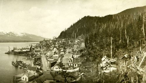 Donor: Ralph Bartholomew Photograph courtesy Ketchikan Museums Click here to view the original panoramic photo...
In the April 9, 1900 copy of Ketchikan's first newspaper, the Helm Bay and Ketchikan Miner, there was an advertisement for Young's store. It read "J.W. Young and Son, general merchandise. Miners and Prospectors outfits, a specialty." The location was "North Ketchikan." But not long after that, the Ketchikan Mining News ran an advertisement for Young's store that listed the address as "Newtown." Young served on the Ketchikan City Council and then died of typhoid in 1904 and his wife and members of her family ran the store for the next 30 years. The family also built a float for 15-20 fishing boats to tie up in front of the store, which was the forerunner of City Float, now called Casey Moran Float. In 1902, the city council took action to improve the access to Newtown. "It may have been on his (Young's) motion that council passed an ordinance Nov. 5, 1902 to build a 10-foot wide "sidewalk" from the intersection at Front and Grant along the water and the around the knob of rock to Newtown for a total of 1,200 feet," June Allen wrote in 2002. "Property owners along the way were assessed at the rate of 25 cents a foot. One R.C. Turner got the job on his low bid of $1,210. That 'sidewalk,' wide enough to accommodate a horse and dray wagon and still leave room for pedestrians opened Newtown's way to downtown docks and services. It would be another half century before today's tunnel was blasted through the rock." 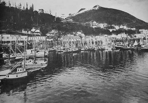 building pictured in the middle with the large roof. Owner of the original photograph George (Bud) Beck Digital image by SitNews - Courtesy of George Beck
Additional growth meant improved access to the Newtown area, according to Rolfe Buzzell. "In 1907-08, Water Street was constructed on pilings around the bluff and north along the shoreline, replacing a large part of the boardwalk," Buzzell wrote in 1991. "A combination of large and small shops and commercial/industrial businesses relating to mining, commercial fishing or related services business, dominated the waterfront." By the mid 1910s, the local mining industry was on the downswing and commercial fishing was the engine that was driving the local economy. Ketchikan's population was rapidly reaching the point where Ketchikan was the largest city in the territory of Alaska. Canneries were beginning the sprout up north and south of the downtown. The current Waterfront Storage property was home to both Ketchikan Packing and Beegle Packing in 1920s. The area north of the Norby Building (built in 1925) was occupied by the Balcom-Payne cannery. City Float was built in the 1920s and initially served as the home of many of the more than 100 vessels in Ketchikan's halibut fleet. The stately homes along "Captain's Hill" on Water Street were built in the 1920s and 1930s, so the halibut captains could keep on eye on their boats at City Float. In the 1920s, Water Street was rebuilt once again and extended north as Tongass Avenue to Ketchikan's West End. In 1954, it was widened once again as part of major town reconstruction due to the opening of the Ketchikan pulp mill. It was at that point that the tunnel was built to create better traffic flow into and out of Newtown. 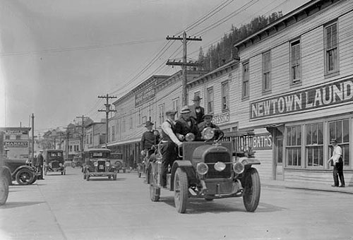 fire truck on Water Street, circa 1930 Photographer: Elliot L. Fisher ; Donor: George L. Beck Photograph courtesy Ketchikan Museums
The First Lutheran Church - at the northern end of Newtown - is on the National Register of Historic Places. It was built in 1930 primarily by the families of the Norwegian fishermen in the community. The current Taquan Building at 1007 Water Street also has a very long history. Buzzell notes that it was built in 1912 and served as the Northern Machine Works building in the early 1970s. The current façade of the building has changed very little over the years - despite the fact the entire building had to be moved in one of the road widening projects. It is one of the oldest unaltered commercial structures in town. The historic survey of 1984 also points out the so-called "flatiron" building, a triangle shaped property at the southern end of Hopkins Alley. Built in 1912 it housed the Horse Shoe Bar for many years. Hopkins Alley itself is also one of the more interesting streets in Ketchikan's history. According to the Historic Properties Survey of 1984, it was created when the boardwalk from downtown Ketchikan was expanded into Water Street in 1907-08. 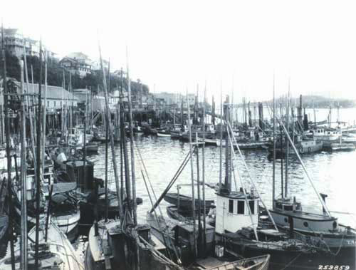 Ketchikan was then the greatest fishing center on the Pacific Coast. Fishing in Alaska then accounted for 80 percent of all employment with most activity limited to the summer months. Fish & Wildlife Service: Photo courtesy National Marine Fisheries Service
Melvin Hopkins was a prominent local doctor and an early member of the city council. He built his home along the Newtown shoreline in 1901. Hopkins Alley serviced the fishing fleet in a variety of ways. "During prohibition, Hopkins Street was known as Home Brew Alley," according to the properties survey. "Several dwellings were beer joints and speak easys. Some say there were no "girls" on Hopkins Alley, but others tell of two "cathouses" where booze was also sold. After prohibition, when drinks flowed at many bars, the Hopkins Street bootleggers went quietly out of business."
Contact Dave at dave@sitnews.us Dave Kiffer ©2005
|