A Long Day's Journey into Behm Canal By DAVE KIFFER April 25, 2006
But the chance to see a part of the area that most Ketchikan residents rarely see spurred several hundred mostly locals to board the state ferry Malaspina for a 12 hour trip around Revillagigedo Island on Friday. Passengers were treated to a rare spring day in which the seas were flat calm, the skies were generally sunny and the only breeze was the chill created on the bow by the 16 knot speed of the vessel. The trip also proved to be a wildlife viewing extravaganza as whales, sea lions, porpoises, mountain goats and black bear were all seen along the way. The trip had barely begun when the vessel had to slow southbound through Tongass Narrows as a small humpback whale appeared to play at the bow the ferry and then swim alongside the ship for several minutes before breaking off to chase some feed near Pennock Island. 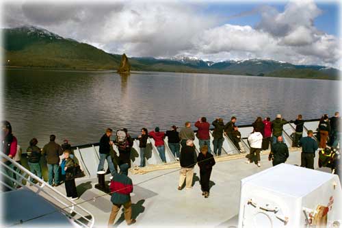 the Malaspina sailed on to Rudyerd Bay. Photograph by Dave Kiffer
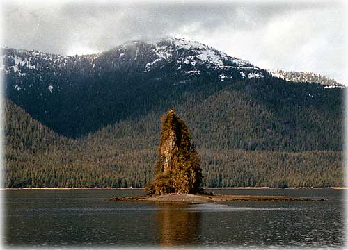
Each summer, more than 100,000 visitors fly or boat out to Misty Fjords, yet - while some locals do use their boats or planes to see the rest of the island, it might as well be the dark side of the moon as far as most locals are concerned. Far more Ketchikan residents have seen Seattle than have seen, for example, Ella Lake or Point Whaley. That's why, whenever the Alaska Marine Highway System offers an around the island cruise, it always sells out. Even on a Friday. This year's trip on the Malaspina was also a treat because the southern Southeast public rarely gets to ride on the oldest ship in the fleet anymore. Ever since the Kennicott came on line in the late 1990s, the 43-year-old Malaspina was been usually relegated to summer day boat runs between Juneau and the communities in Lynn Canal. The Malaspina was actually supposed to be decommissioned in 1997, but is still serving Alaska more than a decade later. The site of it always brings a pang of recognition to the old timers who remember when the "Blue Canoes" first started plying local waters in the early 1960s. This years trip went south from Ketchikan, down Revillagigedo Channel, into East Behm Canal, around the tip of the island, down West Behm and back into Tongass Narrows and into Ketchikan. The relaxed pace of the half day trip allowed passengers to read books, play cards, talk with friends, sightsee, and - judging from the high number of people curled up asleep in the chairs - rest and recharge. Perhaps it was the early rising for the 7 am lineup or maybe it was the peaceful thrum of the Malaspina's twin, 4,000 horsepower diesels, but quite a few people found the trip very relaxing! The trip along the Behm Canal also allowed the passengers to retrace the steps of English sea Captain George Vancouver who visited, mapped and named most of the area in the early 1790s, long before the Russians began their colonies at Sitka and Wrangell. It was Vancouver, after all, who gave Revillagigedo Island its name in 1793. He named it after a Spanish nobleman who was the Count of Revilla Gigedo and the Viceroy of Mexico. If that seems like a mouthful, consider the Spaniard's full name: Don Juan Vincente deGuermes Pacheco de Padilla Horcasitas! After passing Point Alava (named after the Spanish Governor of Nootka) and turning into east Behm Canal, the ferry entered Misty Fjords, the national monument that includes both the mainland to the east of the canal and some of the island of Revilla to the right. Although the creation of the national monument and wilderness area in the late 1970s and early 1980s was highly controversial locally, these days it is clear that visits to the monument are a major component of the local visitor industry. The first milestone on the trip was New Eddystone Rock, a 230-foot high rock spire sitting nearly square in the middle of the Canal. It looks almost exactly the same today as when one of Vancouver's crewmen, John Sykes, sketched it in 1793. It is essentially a volcanic plug of basalt that was formed when lava reached the surface through a weak spot in the crust and solidified, creating a portion of rock that was stronger than the surrounding rock. The surrounding rock eventually eroded away, but not the plug. When I was a child, the local legend was that New Eddystone Rock was actually the top of Mt. Edgecumbe and had been blown off in eruption! Vancouver named the spire after the lighthouse rock of Plymouth, England. The lighthouse at Plymouth must have cast a strong beam on English mariners because various other explores named Rudyerd Bay, Smeaton Island and Winstanley Island after engineers associated with the building of successive lighthouses at Eddystone.
Photograph by Dave Kiffer
After stopping to give New Eddystone Rock its "photo opportunity," the Malaspina sailed on to Rudyerd Bay and the almost indescribably spectacular Punchbowl Cove. Punchbowl is sometimes called the "Yosemite of Alaska" and the comparison is apt. On the east side of the cove there is a 3,150 vertical granite cliff that goes from tidewater to the top of the mountain. But Punchbowl isn't the only spectacular sight within Rudyerd's Bay's 11-mile deep fjord. The Malaspina idled for more than an hour within the bay, the bridge announcing various goat sightings on the other steep cliffs and the camera and binocular holding passengers rushing back and forth across the deck. Eventually, the Malaspina went back out into Behm Canal and motored north past Walker Cove, in the shadow of the 4,000 and 4,500 foot high tidewater peaks ringing that portion of Misty Fjords. At Point Whaley, the northern tip of Revillagigedo and across Behm Canal from Burrough Bay - the mouth of the Unuk, Eulachon and Klehini rivers, - the Malaspina turned west and entered Behm Narrows, passing Bell Island and its famous hot springs. Roppel writes that Native people were known to "travel for miles to visit these springs which were known as a sure cure for painful joints and other ailment." By 1899, the first white residents of the area had built a house and a small bath house in at the springs with a wooden trough supplying the bath with hot water. In 1902, the Ketchikan Red Men Lodge built a larger bathhouse for its members. Then George Roe - who came to the area seeking a cure for an "incurable" affliction - developed the property into a resort with a second bathhouse, a number of cabins and a boardwalk. After Roe died in 1914, several attempts were made by the federal government to take control of the hot springs but they were rebuffed by the courts and the resort property passed through several owners. It was operated as a lodge that was open to the public and was exceeding popular with Ketchikan residents. It was a particularly popular site to visit during the Prohibition Years. Since 1984, the property has been owned by a group of Texas investors and is a private club, but there is a public Forest Service trail nearby. After passing the resort, the Malaspina turned southward into Hassler Pass and Gedney Pass before entering West Behm Canal proper. On the way toward Clover Pass, it passed Traitor's Cove and Escape Point, which both figured in a less peaceful encounter between Vancouver and the local Natives. Vancouver called the cove, Traitor's Cove, because he met a group of Natives in canoes that at first seemed peaceful but then became aggressive and attacked his crew. Several Natives were killed in the skirmish. At least two members of Vancouver's crew were wounded. The Malaspina then snaked its way through Back, Grant and Betton islands - with a short pausa, apparently because of some activity at the Back Island naval facility - before turning the corner at Point Higgins and heading into Tongass Narrows for the short trip back into Ketchikan. After 12 hours at sea, it was
time for the residents to return to their little, civilized corner
of Revilla.
Contact Dave at dave@sitnews.us Dave Kiffer ©2006
|