Detecting Landslides from a Few Seismic Wiggles
December 27, 2015
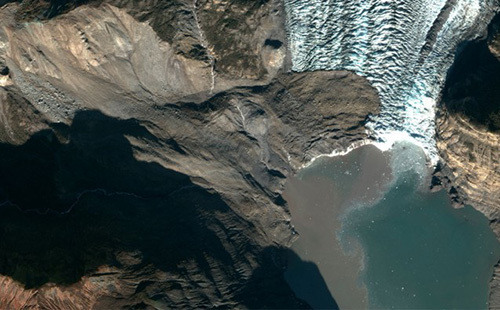
No one was near the glacier to witness the massive landslide—the largest detected in North America since the collapse at Mount St. Helens—and it almost went unnoticed. Almost. Its signature appeared almost simultaneously in seismograms monitored by the Global CMT Project at Columbia University’s Lamont-Doherty Earth Observatory on the other side of the country.
A 200 million ton landslide landed on the toe of Tyndall Glacier and in the water of Taan Fiord on Oct. 17 local time in Icy Bay, Alaska. It was detected by seismologists on the other side of the country.
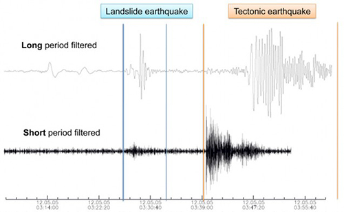
When computers detect earthquakes, they look for an abrupt start to seismic activity, typically a sharp, high-frequency burst. Landslides have a different signature that often goes undetected. “Landslides start very gradually. They grow and they decay over the time period it takes for the mass to go all the way down, so this would be a minute or maybe two,” Ekström said. To pick out landslides, the scientists look for long-period seismic waves—seismic wiggles with a period of 50 seconds or so.
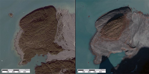
An island in Taan Fiord, about 10 km from the landslide, shown by satellite in 2014 (left) and a few days after the landslide and tsunami (right).
The team at Lamont has analyzed about 50 massive landslides over the past six years, including several that had never been reported. Landslides associated with earthquakes can be difficult to pick out from all the seismic noise accompanying the slipping fault, but other landslides can be isolated. A few days before the collapse in Taan Fiord, they detected a landslide in the Yukon—45 million tons of rock and ice had tumbled down Mount Steele, one of Canada’s highest mountains. Just after Valentine’s Day in 2014, they saw the signature of about 70 million tons of debris sliding down Mount La Perouse near Alaska’s Glacier Bay. Ekström and Stark have also used details of the collapse on Mount St. Helens in 1980 and from the deadly Hunza-Attabad landslide of 2010 in Pakistan to fine-tune their ability to calculate the forces. The Pakistan landslide had dammed a river, creating a lake that slowly inundated villages and raised a risk of future dam-break flooding. “We get a lot of events in the Himalayas, but almost 50 percent seem to come from Alaska,” Stark said. “They are typically in high mountain areas that are actively tectonically deforming, where mountains are being made and destroyed.” Taan Fiord, near Icy Bay, and the surrounding area along Alaska’s St. Elias, Chugach and Wrangell Mountains is one of the most seismically active in the world. Mountains are still coming up, and the erosion rate is fast because of the fragile nature of the rock, which is often volcanic, and because of its glacier activity. “Weak rock, rapid tectonic deformation, fast uplift rates make high mountains prone to landslides,” Stark said. In the case of the Taan Fiord landslide, the Tyndall glacier’s retreat from the edge of Icy Bay in 1961 to its current location more than 17 kilometers up the fiord removed buttressing in the valley, leaving the weak rock on the valley wall prone to collapse, Ekström said. The entire valley was once filled with ice as much as 400 meters high, but as the glacier retreated, the ice thinned.
Comparison of the seismic signatures of a landslide and earthquake from events in the Himalayas on May 5, 2012.
“For the first few years, we were a little reticent to say we detected these giant landslides that no one else had noticed. How could they not notice?” Stark said. “It took us a while to be confident, but from analyzing about 50 of these, we have been able to constrain the physics and get the numbers—momentum, kinetic energy—we get dynamics that are impossible to get any other way. We have improved understanding of the physics of landslides.”
Edited by Mary Kauffman, SitNews
Source of News:
|
||