Project tests method for monitoring ice conditionsBy SUE MITCHELL
November 17, 2016
Researchers from the University of Alaska Fairbanks Geophysical Institute and the National Park Service have successfully tested a method to measure how much floating ice exists and how it is changing. Their work may help scientists and policymakers better understand how changing ice conditions affect the harbor seals.
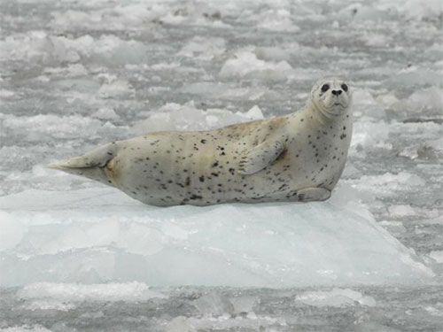
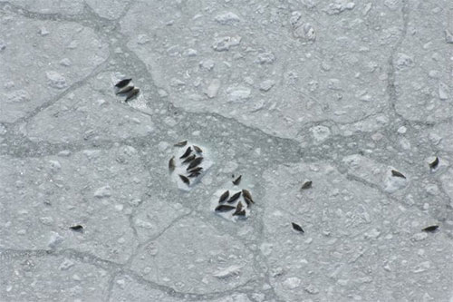
A harbor seal rests on an iceberg in Southeast Alaska’s For eight years, NPS employees collected aerial photos of seals and ice in Johns Hopkins Inlet, a fjord in Glacier Bay National Park and Preserve. To develop a way to process the information in the photos, the park employees worked with scientists at the University of Alaska Fairbanks’ Geophysical Institute under a Cooperative Ecosystems Studies Unit grant. “This is the first study to develop a semiautomated method that can be used to systematically quantify glacier ice habitat in tidewater glacier fjords from aerial photographic imagery,” said Jamie Womble, a wildlife biologist with Glacier Bay National Park and Preserve. As we view an image, our eyes register colors and shapes, the location of an object and its relationship to others in its immediate neighborhood. We use all this information to decide what type of object it is. New generations of sensors record images at a resolution fine enough to allow computers to do the same thing - recognize and categorize objects based on defined variables.
Harbor seals occupy icebergs surrounded by brash ice in Johns Hopkins Inlet, a fjord in Glacier Bay National Park and Preserve.
“This study is an example of a great interdisciplinary collaboration between marine ecologists, glaciologists and remote sensing scientists from the UAF Geophysical Institute and the National Park Service,” Womble said. The work, by Womble and the Geophysical Institute’s Robert McNabb, Anupma Prakash, Rudiger Gens and Christian Haselwimmer, was supported by Glacier Bay National Park and Preserve. It was published in the peer-reviewed journal PLOS ONE on Nov. 9.
This column is provided as a public service by the University of Alaska Fairbanks. Representations of fact and opinions in comments posted are solely those of the individual posters and do not represent the opinions of Sitnews.
|
||