the Rockies to south-central Washington November 4, 2003
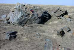
Although glacial deposits of rocks and boulders are common, especially in the upper Midwest, "There probably isn't anyplace else in the world where there are so many rocks that rafted in on icebergs," said Bruce Bjornstad, a geologist at the Department of Energy's Pacific Northwest National Laboratory in Richland, Washington. The rocks were left after ice dams holding back a huge lake near Missoula, Mont., broke, re-formed and broke again from 1 million to 2 million years ago to as recently as 13,000 years ago. The floodwaters backed up at the downstream end of the Pasco Basin behind Wallula Gap, a narrow ridge opening through which the Columbia River flows today. The lake lapped the gentle slope of Rattlesnake Mountain, northwest of the gap and part of the Hanford Reach National Monument in south-central Washington Rattlesnake Mountain was the highest peak protruding from the 800-foot-deep temporary body of water, dubbed Lake Lewis. The rocks and boulders, so-called erratics, grounded as the waters of Lake Lewis receded after a few days like a slowly draining bathtub. Bergmounds and larger rocks were carried by large icebergs and were generally deposited below 1,000 feet. 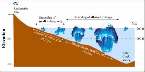 and were generally deposited below 1,000 feet.
The erratics were concentrated along northeast-running gullies. Bjornstad suggests that the speed of the flowing water varied as it crossed an uneven surface, and that may have created eddies that forced an ice jam in the deeper, quieter waters at the back of these gullies. The erratics and bergmounds decreased as the surveyors worked up the mountainside. Bjornstad attributed the lower number to smaller successive floods. Bjornstad and his colleagues found that most of the erratics were rounded, showing the effects of weathering and suggesting that they were carried in by older Ice Age floods. Collaborating with Bjornstad on the study were Elysia Jennett, Northern Arizona University, Flagstaff; Jenna Gaston, U.S. Fish and Wildlife Service, Hanford Reach National Monument, Richland; and Gary Kleinknecht, Kamiakin High School, Kennewick, Washington.
Source of News Release:
|
||