
The Specter of a Mega-Tsunami in AlaskaBy ADAM VOILAND
October 16, 2020
He was soon inspecting the area using Google Maps, zooming in to the maximum extent possible and searching for signs of slippage. He saw the cracks as well, but nothing about them struck him as strong evidence of a big landslide. “But it turns out I had made a geology 101 error,” he said. “I hadn’t zoomed out enough, and I missed the big picture.” Still, he kept Barry Arm on a list of possible landslides to investigate more someday. A few months later, Chunli Dai offered that chance. The Ohio State researcher was working on a NASA-funded project to develop new ways to automatically detect landslides in the Arctic, and she was looking for test sites to check how well the tool was working. Her project makes use of a high-resolution dataset called ArcticDEM and machine learning to automatically search for and flag landslides.
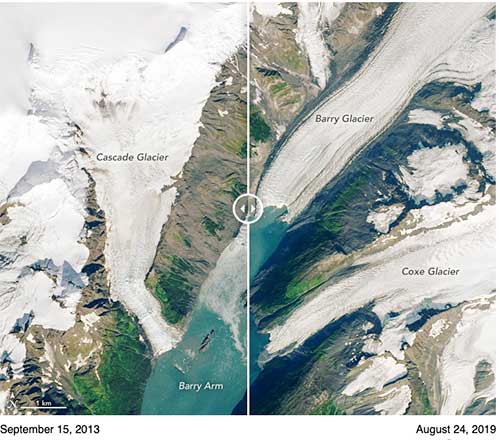
When Dai used her tools to survey the Barry Arm area, she got some eye-popping results—an entire mountainside near Barry Glacier was slowly and subtly shifting. If the giant, slow-moving landslide were to suddenly collapse into the narrow fjord below, it would generate an extremely large tsunami because of the way the fjord's shape would amplify the wave. “It was hard to believe the numbers at first,” said Dai. “Based on the elevation of the deposit above the water, the volume of land that was slipping, and the angle of the slope, we calculated that a collapse would release sixteen times more debris and eleven times more energy than Alaska’s 1958 Lituya Bay landslide and mega-tsunami.” That event, which was triggered by a 7.8 earthquake, dropped millions of cubic yards of rock about 2,000 feet (600 meters) into a fjord. It produced what is thought to be the tallest wave (1,700 feet) in modern history. In an event that eyewitnesses compared to an atomic bomb explosion, the huge wave washed away soil in a wide ring around the bay and obliterated millions of trees. [See SitNews July 2008: SURVIVING THE BIGGEST WAVE EVER, 1,700 Foot Wave Devastated Lituya Bay By DAVE KIFFER] Yet Higman and several of Dai’s colleagues were initially skeptical that there actually was a slide in Barry Arm. The size of the landslide Dai was reporting was enormous—far bigger than any other known landslides in Alaska. Her detection technique was new and untested. And in some other areas, the presence of snow cover, shadows, or clouds caused the tool to erroneously label features in satellite images as landslides when they clearly were not. But Dai kept looking and checking other types of satellite data, including a decades-long series of Landsat images of Barry Arm via Google Timelapse. When she scrutinized 2013 and 2016 satellite images of the area, it became abundantly clear that her ArcticDEM results were real. “With the wider perspective from Landsat, the movement of the slope was impossible to miss,” she said. “You can see a whole section of the mountain between Cascade Glacier and Barry Glacier slumping toward the water.” (In the Landsat images at the top of this page, use the slider to see the movement for yourself.) The slope moved forward by about 400 feet (120 meters) between 2010 and 2017. Since 2017, it has moved very little.
Immediately after seeing the Landsat images, Higman was also convinced something serious was happening and alarmed about what it could mean. Since then, he has been reaching out to colleagues and coordinating with state and federal partners to evaluate the risk. In May 2020, a group of 14 scientists published an open letter warning that a landslide-generated tsunami is likely within 20 years and could happen at any time. If a landslide occurs, the resulting tsunami in Barry Arm could produce waves that are hundreds of feet high. Other, more distant bays—such as the more heavily populated Passage Canal (about 30 miles/50 kilometers away)—could see 30-foot (9-meter) waves. By looking back at older satellite images and aerial photographs, the team of scientists has determined that slippage in this area is nothing new. They think the slope began to shift at least 50 years ago, but it appears to have sped up between 2009 and 2015, just as the front of Barry Arm glacier was retreating. “The slope probably sped up because the glacier that had been supporting the bottom of the slope retreated,” explained Higman. “When warming temperatures caused that ice to retreat, the slope was free to move.” The open letter prompted new monitoring projects at the U.S. Geological Survey, the Alaska Department of Natural Resources, and the National Atmospheric and Oceanic Administration. Researchers are now working to track the slope’s motion with synthetic aperture radar on satellites, aerial lidar, and aerial photography. Other scientists are setting up gauges to detect tsunami waves in advance. And others are working to make better maps of the bathymetry (shape of the seafloor) of the fjord to more accurately model how a tsunami might move through it. “We have learned a tremendous amount about this hazard, and I think we have done a good job of getting the word out about it,” said Higman. “But there are still a lot of really interesting and important scientific questions that we are only barely starting to investigate.” For instance, why did the landslide stop slipping in 2017 and does that mean it is less likely to collapse in the short term? Also: can we expect to see a sharp increase in this type of hazard as more and more glaciers retreat? “These are fairly unusual events, and scientists have only started studying the connections between glacial retreat and landslide tsunamis in the past few decades,” he said. “We don’t have a very long or deep record to look at yet.”
Note: NASA Earth Observatory images by Lauren Dauphin, using Landsat data from the U.S. Geological Survey. On the Web:
Edited By Mary Kauffman, SitNews
Source of News:
|
|||||