The Alaska Highway or, The 'Alcan': What did it have to do with Ketchikan?By JUNE ALLEN
October 27, 2017
That wartime highway hundreds of miles to the east and north dashed Ketchikan's hopes for a new road system across Revilla Island. Also dashed were plans for expansion of the town's unique little City Park and a road replacing Deer Mountain trail. And the present drive for today's proposed multi-million dollar bridge is not the first time Ketchikan has lobbied for a bridge! The proposal for a bridge - with ups and downs and lengthy periods of inaction, began in Ketchikan back in the 1920s!
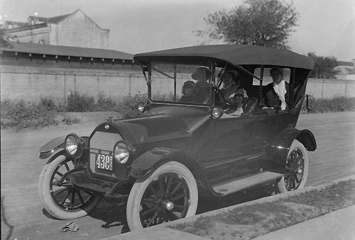
It all really started with Henry Ford's production line automobiles that even a working man could afford. By the mid-1920s the United States was awash in autos of several makes and models of "touring cars" that rumbled along dirt roads, through mud and sand, and jolted through potholes all across the nation, traveling to see the sights and visit new places. This new pastime/industry was called tourism. The new industry led to the need for better roads, for paved interstate highways, for gussying up local attractions along the way to lure tourist dollars. As more and more roads were built, recreational travelers began to dream of more spectacular and exciting routes. And thus, in the prosperous and roaring '20s, was born the dream of what was dubbed the International Highway, a road that was to begin (or end) at Barrow, Alaska, and drop down through the States and thence southward through Medico, Central America, into South America and all the way to tip of that continent! Today there are stories in the papers every year of travelers - bicyclists and motorcyclists and once or twice a walker - who attempt to travel all of North and South America top to bottom even though the highway as first envisioned was never built. In the touring '20s, such a project caught the imaginations of everyone from Alaska to Argentina. The press took up the vision of an International Highway with all its possible routes and scenic splendors. Such stories were fodder for years for newspaper features and for kitchen and barroom discussions across the nation!
The governments of the countries involved in such a colossal plan were less enthusiastic about such a scheme. They realized the costs of such a giant project, and the essential cooperation that would be required among countries not necessarily politically stable or even friendly to one another. Such realities scarcely dampened the nationwide daydreaming. But the project appeared doomed when the nation, and the world, were plunged into the Great Depression after the stock market crash of 1929. Then President Franklin Delano Roosevelt was elected and took office in 1933, and, perhaps in attempt to cheer up and restore the optimism and confidence of a Depression-weary nation, the dream of the highway seemed to be moving toward reality. Congress authorized a U.S.-Canada commission to study the proposal! A number of routes through Canada and into Alaska were discussed. Alaskans were as caught up in the excitement of such a transportation boon as anyone else, perhaps more so. Because at that time (and until 1946), the only way to get to or from Alaska was by steamship or airplane. So in 1933 the plan that seemed most favored by both Alaskans and Canadians was a more or less coastal route that would wind northward through British Columbia behind its coastal mountain range, roughly the same general route as today's B.C. Highway 37, and then continue into Alaska to hook up with the Richardson Highway (from Valdez to Fairbanks). Respected engineers and civic leaders discussed and debated a number of plans.
Ketchikan's Chamber of Commerce and city fathers were well aware of the proposed international highway and lobbied heavily for it! They had their own plans for hooking up with the outside world. With Ketchikan being located on an island, the town would face the hurdles of building a road across the island and a bridge connect to the mainland and proposed super-highway. Curiously, unlike today's advocates of an overland connection to the mainland, Ketchikan seemed more interested in the permanent settlers that road access would bring in and not at all with the convenience of a way to drive out. But how would it all be accomplished? The excerpts from the following speech give clues. From a speech by Ketchikan Mayor Harry G. Cain in 1939: "The real pathfinders of the past were those of vision of greater things ahead and there are those who are stepping right out in front in the line of progress who, taking a leaf from the pages of the past, foresee the great impulse to be derived from the early completion of the International Highway. Since the present status of the automobile, this has become the traveling age supreme, and with the completion of such a highway, there would be such a stream of Alaskan travel and increased interest in Alaska as has never been seen. Alaska would be better advertised and understood and a greater impulse to settlement and progress during the next five years than it has experienced since it was acquired from Russia, and we must not sleep and dream. "We must connect with that highway! I see it reported that an enterprising photographer is advocating trips to the of the Naha River, above Loring, where movie pictures can be taken of black bear feeding in the stream during the spawning run. This is a wonderful sight to see, to see the salmon leaping the falls and with bear catching them makes it a thriller of a lifetime.
"Why delay the construction of a road across the island, so much needed, to visit this and many other interesting and scenic wonders while crossing the island [and bridge] and on to Portland Canal and Hyder. We also want the road extended up the Unuk River." He also said that Deermount Street "should be continued through and on to the peak of Deer Mountain." He suggests not only the continued improvement of City Park but side features along this road to the top of Deer Mountain, to make it "an outstanding attraction." He ends his speech with, "Bear in mind that the world's greatest attractions are nature's settings made superbly attractive by man." (Much has changed since 1939 when that speech was delivered. It is no longer possible to build a road to the back side of Revilla Island or a bridge over Behm Canal to the mainland because since 1980 all of that stretch of Behm Canal is bordered on both sides by wide swaths of the wilderness lands of the huge Misty Fjords National Monument - where no road or development of any kind is allowed.) Hopes for the International Highway were fading fast by 1940 when war clouds were gathering over America. After the Japanese attack on Hawaii's Pearl Harbor on Dec. 7, 1941, America entered World War II. With the Japanese in control of the Pacific - and a serious threat to the Pacific Coast states, America's military leaders recognized also the threat to Alaska and its undefended Aleutian Islands. With a foothold in the Aleutians, the enemy could use the coast of Alaska as stepping stones south to attack major Pacific Coast cities. A military road to mainland Alaska was needed immediately!
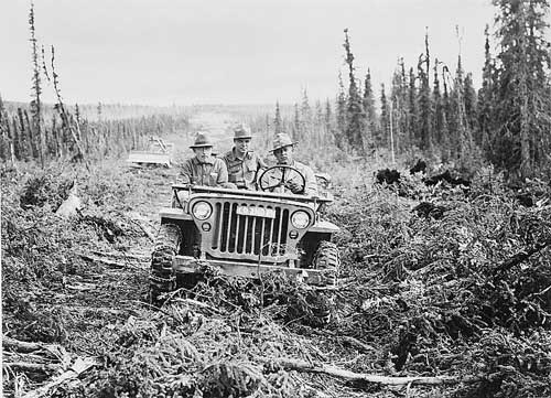
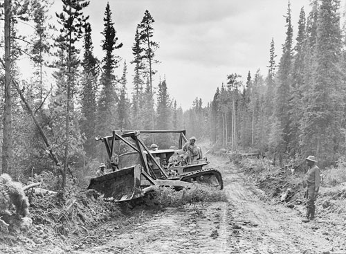
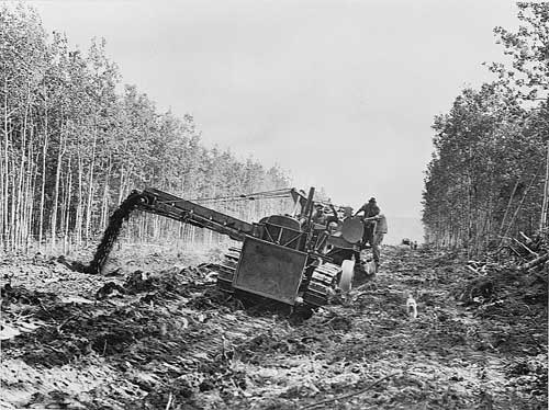
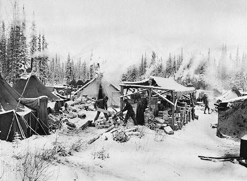
Military heads bent over maps of the vast uninhabited expanses of Canada. As the highway route was roughed out, Army Engineer units were mobilized and civilian contractors recruited. The road-to-be was named the Alaska Military Highway. It would not be built along the scenic trails closer to the coastline but would start at the Canadian railroad terminus of Dawson Creek, B.C. - located inland on the border with Alberta - and would be distanced as far as possible from enemy reconnaissance aircraft. Along that route, the road would of necessity traverse appalling stretches of muskeg and permafrost, bridge unnamed streams and search out mountain passes. Within three months of Pearl Harbor the first trainload of men and supplies arrived at Dawson Creek, ready to start construction of the road. Others troops were sent ahead to work farther up the line. The road was to be hacked out from both ends. That was in March of 1942. Three months later, on June 3, 1942, Japanese bombers from carriers in the North Pacific attacked Dutch Harbor on Unalaska Island. They returned the following day and set oil tanks afire and damaged the hospital and a barracks ship. At the same time, their ground troops had invaded and occupied two others of the Aleutian Islands, Kiska and Attu. It is the only time in history that an enemy had invaded and occupied U.S. soil! The south and north crews building the military highway, dubbed the Alcan by the workers, met eight months and 11 days after they began, on Nov. 20, 1942; the road was open for the transport of men and supplies! It was an astonishing feat, accomplished by more than 16,000 men, at a cost of $138 million. The 1,671-mile long pioneer road was completed. It was a rough, winding, often muddy road that crossed streams on temporary bridges. But improvement to the road continued throughout the war, which ended in August of 1945, when Japan surrendered. In peacetime, the Alaska Military Highway, the "Alcan," was officially renamed the Alaska Highway. The highway was closed to civilian traffic until 1946. Even then, and for the next decade, escorts of heavy equipment were necessary for vehicle travel as certain parts of the highway were straightened or otherwise improved. Long waits were required as vehicles stopped in line, waiting to be allowed to continue. In wet weather the road was mostly gluey mud; in dry weather it was thick with dust. There were few places to stop for gas or meals or rest rooms. The mosquitoes thrived. Rocks cracked windshields. Cars traveled with stacked spare tires. Today the highway is straightened and completely paved. The postwar crossroad settlements of a few residents are now large cities. But it was, and still is, a thrilling adventure to be able to drive to Alaska! After the war, the idea of the International Highway had faded. Air travel was a faster and easier way and has become the accepted mode of transportation. Times change. Ketchikan's earlier hopes for a road connection were dashed and then forgotten. The arrival of state ferry service in 1963 allowed car-ferry travel to Prince Rupert or to Seattle (then, now Bellingham). With weekly ferry and daily air service, is a road connection still a priority?
Representations of fact and opinions in comments posted are solely those of the individual posters and do not represent the opinions of Sitnews.
|
||||||||