Uncharted: Exploring one of America’s fastest faultsA team of USGS scientists spent 10 days in the wilderness investigating the Fairweather FaultBy DONYELLE K. DAVIS
October 23, 2016
Immediately after the 1958 earthquake, USGS geologist Don Miller along with University of California, Berkeley geologist Don Tocher surveyed parts of the ground rupture accessible by helicopter. Up until now, their observations were virtually all that was known about the seismic potential of the southern Fairweather Fault on which the 1958 quake occurred.
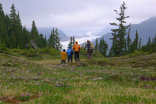
USGS research team pauses to take in the view of South Crillon Glacier from a study site along the Fairweather Fault in southeast Alaska.
“We hope our research will shed light on how often the fault has produced large earthquakes like in 1958,” Witter said. “We’re also learning more about how tectonic deformation along the plate boundary has contributed to building the Fairweather mountains, which have the highest relief among coastal mountain ranges worldwide.” Witter’s field team included USGS geologists Adrian Bender, Chris DuRoss, Peter Haeussler, Richard Lease and Kate Scharer. Each wielded their own scientific specialities, ranging from lidar imaging and understanding mountain building, to trenching across the fault for prehistoric quakes. The largely uninhabited area around the Bay is a part of the Glacier Bay National Park and Preserve and sits on top the Fairweather fault. The land blocks on either side of the Fairweather fault move past each other nearly twice as fast as the San Andreas Fault, at about five centimeters a year (2 inches/year), making it one of the fastest-moving faults in the country. San Andreas-fault expert Kate Scharer noted that while there are not large communities on the fault, a rupture on the Fairweather Fault could still negatively impact southeast Alaska. For example, earthquake-produced landslides can affect infrastructure and lifelines that connect the state capitol, Juneau, to the rest of the globe. New Technologies Pave The Way Earthquake technology has come a long way with the evolution of satellite imaging and lidar mapping. Lidar, which stands for Light Detection and Ranging is a technology similar to radar and is used to create high-resolution digital elevation models. Lidar equipment includes a laser scanner, GPS and an Inertial Navigation System and is generally mounted on a small aircraft. Recent advancements with lidar allow more accurate measurements and information than before. “With lidar, we were now able to see through the thick forest, whereas in the past Don Tocher and Don Miller could only use air photos,” Scharer said. “ Lidar ‘strips away the trees,’ so now the ground surface is visible and we’re able to see traces of fault movement.”
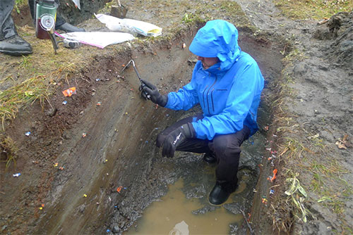
The team’s work included excavating trenches across the fault to examine layers of sediment.
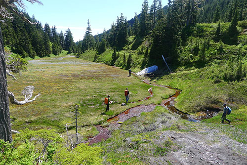
“Closer examination of the fault entailed mapping fault-related landforms—the geomorphic expression of past earthquake ruptures on the fault—with the aid of detailed topographic maps derived from new lidar data acquired for this project in September 2015,” Witter said. “ Our field investigation involved verifying the lidar-based mapping, and trenching across active traces of the fault to explore the history of past earthquakes.” The scientists will send the collected samples to a lab for radiocarbon dating, in order to get the timing of past earthquake ruptures evident in the trench exposures. “We will take what we observed in the field and mesh it with our preliminary map of active fault traces based on lidar,” Witter said. “Next year, we hope to return to the Fairweather Fault to study uplifted marine and river terraces that flank Icy Point.” By studying these terraces, the team plans to learn more about the area’s coast, which has been uplifted by the fault. They hope to measure and date the uplift in order to determine how fast the fault is moving and the impact of it on the earth’s surface. A Day In The Life The valuable research was hard-earned and did not come without labor-intensive days and challenging nights. Every day the group hiked for hours, gaining at least 1600 feet in elevation, ascending the mountain covered with devil's club, alder, spruce and a thick moss carpet; often arriving at their destination in the rain: wet, tired and hungry.
Glacier Bay National Park
The work was hard and long but worth every single challenge. “The most rewarding thing was working with such a skilled and solid team of scientists. It is extremely rewarding to work with dedicated, thoughtful, and insightful people like Kate and everyone on our team,” Witter said. “This teamwork results in better science products, builds trust, and strengthens collaboration on future projects. It is essential to have a team that’s hard working and can adapt to the inevitable challenges faced when you do fieldwork in Alaska, and our team performed very well.”
NOTE:
Related:
Representations of fact and opinions in comments posted are solely those of the individual posters and do not represent the opinions of Sitnews.
|
||