 Scientists Use Satellite To
"Pond-er" melted Arctic Ice
Scientists Use Satellite To
"Pond-er" melted Arctic Ice
October 03, 2003
Friday - 12:50 am
NASA researchers and other scientists used a satellite combined
with aircraft video to create a new technique for detecting ponds
of water on top of Arctic sea ice. Until now, it was not possible
to accurately monitor these ponds on ice from space.
Water that forms on sea ice
during the summer, called a melt pond, absorbs the Sun's energy
rather than reflecting it back to space the way ice does. The
balance between reflected and absorbed energy has a large effect
on Arctic and global climate. When more ponds of water form on
the Arctic sea ice cover in early summer, more heat is absorbed,
causing the Arctic's sea ice cover to melt faster during the
summer. Knowledge of when and where these melt ponds form will
help scientists calculate the balance of energy in the Arctic
and improve their knowledge and projections of climate both regionally
and globally.
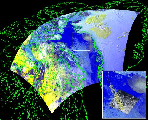 Baffin Bay Region,
June 27, 2000
The larger background
is an Advanced Very High Resolution Radiometer (AVHRR) scene
of the Baffin Bay region on June 27, 2000. The inset in the lower
right corner shows a gray scale Landsat 7 image for the same
day; aircraft tracks are in yellow. Credit: NASA
Baffin Bay Region,
June 27, 2000
The larger background
is an Advanced Very High Resolution Radiometer (AVHRR) scene
of the Baffin Bay region on June 27, 2000. The inset in the lower
right corner shows a gray scale Landsat 7 image for the same
day; aircraft tracks are in yellow. Credit: NASA
By using detailed aircraft video of Arctic surfaces and
comparing those with coarser satellite imagery, the researchers
were able to recognize rough features in the satellite data that
corresponded to ponds on ice, ocean water, and un-melted sea
ice. Now, they are able to use a satellite to monitor sea ice,
without the aid of the aircraft video. Satellites offer the advantages
of frequent regular flyovers that cover vast areas all at once.
"Our new technique offers
the possibility of determining when and mapping where these melt
ponds form and would greatly aid our understanding of the Arctic
heat balance," said co-author Donald Cavalieri, a senior
research scientist at NASA's Goddard Space Flight Center (GSFC),
Greenbelt, Md. An article describing the new technique appeared
in a recent issue of the journal, Remote Sensing of Environment.
During spring and summer, these melt ponds cause existing sea
ice to melt faster and greatly reduce the ice's ability to reflect
sunlight. This can create a positive feedback, where an increasing
number of melt ponds absorbs more heat and causes sea ice cover
to melt even faster.
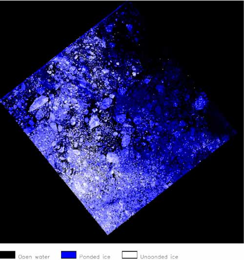
Landsat Image with
Ice and Water Classifications, Baffin Bay Region, June 27, 2000
This is the same image
from Landsat 7 as the gray scale inset in Figure 1, only here
the surface types have been classified by color, using the new
satellite-based technique for measuring melt ponds. The image
shows ice-free water as black, sea ice with pond water on it
(or ponded ice) as blue, and sea ice without ponds on it (unponded
ice) as white.
Credit: NASA
During the warmer months, melt ponds can cover up to 50 percent
of the Arctic sea ice area. There may be a relationship between
the fraction of melt ponds and the amount of sea ice cover at
summer's end. Researchers know from satellite records covering
the last 30-years that the Arctic sea ice cover at summer's end
has been decreasing rapidly. This new technique may help them
determine whether there has also been an increase in the number
of melt ponds over this period.
This new technique to detect
melt pond coverage uses NASA's Enhanced Thematic Mapper Plus
(ETM+) instrument on the Landsat 7 satellite, developed with
the aid of much higher resolution video imagery from a NASA supported
aircraft experiment during the summer of 2000.
"This result is an excellent
example of how the coordinated use of satellites and research
aircraft are used to develop new techniques for observing the
Earth," Cavalieri added.
By using video footage from
an aircraft flight at an altitude of almost one and a half kilometers,
the researchers were able to compare that higher resolution footage
with Landsat 7 images passing over the same path above Baffin
Bay in the Arctic on the same day. They then compared the Landsat
imagery with the aircraft video.
While Landsat 7 shows less
detail, it covers vast areas all at once. The aircraft video,
on the other hand, allows researchers to view a 1.5 meter area
in detail.
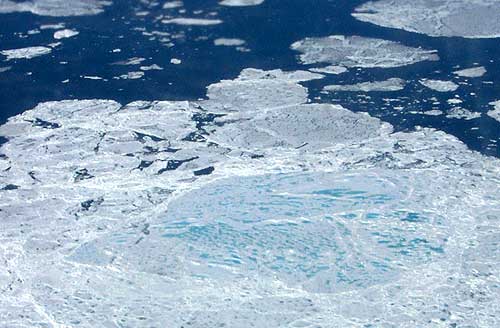 Melt Ponds on Sea Ice,
June 27, 2000
This image shows digital
true-color images of Baffin Bay taken from a Navy research aircraft
participating in the Meltpond2000 experiment. The light blue
areas show ponds of water on the sea ice, white areas are sea
ice without ponds, and the darker areas depict ice-free water.
Credit: NASA
Melt Ponds on Sea Ice,
June 27, 2000
This image shows digital
true-color images of Baffin Bay taken from a Navy research aircraft
participating in the Meltpond2000 experiment. The light blue
areas show ponds of water on the sea ice, white areas are sea
ice without ponds, and the darker areas depict ice-free water.
Credit: NASA
By classifying 13 high resolution images from the aircraft into
areas of ocean, ice with ponds, and pond-free ice and then comparing
these areas with the different wavelength bands of Landsat, the
researchers were able to develop a new method to calculate the
extent of open water, melt ponds, and sea ice over large areas
using Landsat data by itself.
"Previously there were
no systematic measurements of melt ponds, but this technique
with the Landsat creates the possibility of determining when
and where these melt ponds form," Cavalieri said. "It
helps us understand the heat balance, which ties into the global
climate system."
Lead author Thorsten Markus,
who is currently conducting research at sea, is also a scientist
at NASA GSFC. Other co-authors include Mark Tschudi, National
Center for Atmospheric Research, Boulder, Colo., and Alvaro Ivanoff,
Science Systems and Applications, Inc., Lanham, Md.
The study was funded by NASA.
NASA's Earth Science Enterprise is dedicated to understanding
the Earth as an integrated system and applying Earth System Science
to improve prediction of climate, weather, and natural hazards
using the unique vantage point of space.
Source of News Release, photo
& graphics:
Goddard Space Flight Center
- NASA
Web Site
E-mail Editor: editor@sitnews.org
Post a Comment
-------View Comments
Submit
an Opinion - Letter
Sitnews
Stories In The News
Ketchikan, Alaska
|