 by Ned Rozell September 11, 2005
"OK, we've got two, maybe three events here," he said. "Sweet!" said Patty Burns, chief digger on the trench and a geologist with the Alaska Division of Geological & Geophysical Surveys. Burns and two colleagues from Colorado were searching the western part of the Denali Fault in the Alaska Range for evidence of past earthquakes. After several days of shoveling dirt and heaving rocks, the geologists had found proof of a few ancient earthquakes that had torn the former ground surface. 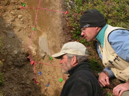 Team look at soil from a trench along Alaska's Denali fault. They were looking for evidence of torn ground that would indicate large earthquakes in the past. Photograph by Ned Rozell
Since that day, geologists from around the world have migrated to the fault zone to learn more about strike-slip earthquakes, the types that occur on both the Denali and San Andreas Faults. Near clear-running Schist Creek, on a treeless landscape heavy with blueberry bushes, you don't have to be a geologist to see the aboveground expression of the Denali Fault as a deep gully running east to west. There, a person can almost straddle the fault; if someone planted one foot on each side while facing west, his or her left foot would move ever so slightly ahead of the right foot as the fault crept along. Researchers have found that the fault slips about 1 centimeter (more than one-quarter-inch) each year near Cantwell. A person wouldn't want to be standing there during an earthquake, though. In 2002, the earthquake relieved hundreds of years of pressure, offsetting some streambeds by more than 25 feet. Earthquake motion also shook large portions of a few mountainsides onto Alaska Range glaciers. Burns, Crone, and Steve Personius, the latter two research geologists with the U.S. Geological Survey's Geologic Hazards Team in Golden, Colorado, were moving dirt in search of characteristic breaks in the soil that might indicate when a big earthquake had torn through the area. Unlike in the eastern Alaska Range, the Denali Fault didn't rupture on its western portion during the 2002 earthquake, which makes some scientists think Cantwell might be due for a jolt. 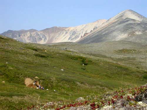 Photograph by Ned Rozell.
Later, in Colorado and California labs, the scientists will try to date soil layers on each side of the soil disturbances to determine when large ancient earthquakes broke the ground surface. How long ago did the western part of the great fault rupture, and when might another large earthquake happen? When the scientists analyze the details of the trench, they may come up with answers of interest to residents of Cantwell and to people who live along other big strike-slip faults. "It'd be good news if we can show this fault behaves in a characteristic way," Burns said. "Then there's a higher likelihood we could estimate when the next earthquake will be."
Publish A Letter on SitNews Read Letters/Opinions Submit A Letter to the Editor
|