|
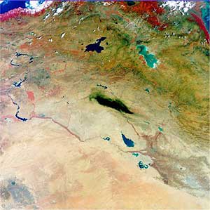
A burning oil pipeline in northern
Iraq produced an immense cloud of black smoke that stretched
across thousands of square kilometres, in this image acquired
by Envisat's Medium Resolution Imaging Spectrometer.
The smoke cloud is visible in the centre of this image of the
alluvial plain occupied by the valley of the river Tigris (flowing
from the top centre of the image) and the Euphrates (flowing
from the top left corner).
The Medium Resolution Imaging
Spectrometer (MERIS) on ESA's Envisat environmental satellite
acquired the image on 30 August, the same day as the media reported
a fire affecting a segment of oil pipeline near the town of Hawija.
The pipeline transports crude
oil from the oil-rich city of Kirkuk seen here in grey,
on the Tigris River - to Baija, where the country's largest oil
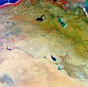
refinery is located. For comparison the second MERIS image shows
the same area three days earlier, before the pipeline had been
damaged.
The dense cloud of smoke has
an extent comparable to the Iranian lake Urmia (which has an
area of 4700 square kilometers), seen in turquoise color towards
the top right of the image. Authorities stated it took two days
to bring the fire under control.
These three-band MERIS images
have a resolution of 1200 meters and were processed by Hamburg-based
Brockmann Consult.
|