Large wildfires a factor in climate equation
August 06, 2015
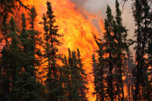
By the middle of July, the Alaska fire season was already the third largest since reliable records began in 1950, with over 4.75 million acres burned. That’s more than double the size of Yellowstone National Park.
Fire is a natural part of the boreal forest, an ecosystem dominated by black and white spruce. This species is designed to burn, with cones that release their seeds when under intense heat.
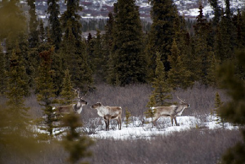
“However, what sets this fire season and the last two decades apart from the historical record is the growing number and frequency of large fire years we are having in Alaska,” Rupp said. There isn’t a direct relationship between climate change and fire, but researchers have found strong correlations between warm June temperatures and large fire years. Hot, dry spring conditions, however, do not automatically mean fire — something needs to create the spark and actually start the fire. Lightning starts about 35 percent of the fires in Alaska but account for 90 percent of the total area burned. “Climate models tell us that average June temperatures will continue to increase through this century, but ignition is the wild card,” explains Rupp. “What will happen in the future is a more complicated story because we don’t understand what will happen with convective storms and the lightning.” Fire makes its mark on the landscape Fairbanks has had seven days this summer when the 24-hour air quality measurements have fallen somewhere between “unhealthy” and “hazardous.” When the consequences of nearby fires are so acute, it can be hard to think about the landscape-scale or planetary impacts, but these large fire years are significant to both. The impacts of fire on the landscape can considerably alter wildlife habitat. For example, wildfire can destroy slow-growing lichens in black spruce forests, a highly nutritious and important winter food source for caribou. In a 2014 study, researchers from UAF and the United States Geological Survey’s Alaska Science Center found that future wildfires are likely to reduce the amount of winter habitat for caribou. “We project that the Porcupine caribou herd will lose 21 percent of winter habitat to fire by the end of this century, with the majority of this loss driven by increased flammability in spruce forests in the Yukon,” said Dave Gustine, a research wildlife biologist with the USGS.
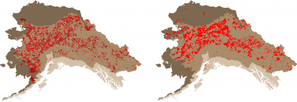
The boreal forest makes up a significant portion of the state of Alaska (medium tan). The maps compare historical fire scars simulated by the ALFRESCO model (left) compared to observed fire scars (right) for the 1950-2009 time period.
Local fires, global impacts Alaska fires are also important in the global system. Like having multiple bank accounts with different balances, specific, measurable amounts of carbon are held in landscape “accounts.” Surface vegetation such as shrubs and trees makes up one account, the organic upper layer of the soil makes up another, and the mineral soil itself makes up yet another. When a fire burns over the landscape, some of the carbon is removed from each of these accounts and released to the atmosphere. Unlike more temperate ecosystems, the boreal forest is unique because it has a very deep organic layer that covers the mineral soil. When a fire burns through the boreal forest, not only is carbon released from the surface vegetation, it is also released from these deep organic layers. As a result, fires burning in Alaska have the potential to release more carbon into the atmosphere than fires occurring in more temperate regions. “In a big fire year, like 2004 or what’s happening now, about 0.2 percent of the carbon stored in Alaska is released,” said Dave McGuire, a research scientist at UAF’s Institute of Arctic Biology and leader of the USGS Alaska Cooperative Wildlife Research Unit. McGuire is one of the lead authors on a forthcoming USGS report on carbon sequestration in Alaska. “The carbon released from fire emissions during a large fire year in Alaska is roughly equivalent to 1 percent of the global fossil fuel and land use emissions.” The USGS report, “Baseline and Projected Future Carbon Storage and Greenhouse-Gas Fluxes in Ecosystems of Alaska,” slated for publication this fall, will provide historical context and long-range estimates for carbon emissions by Alaska wildfires and for biological carbon sequestration in Alaskan ecosystems. This Alaska report on land carbon is part of a comprehensive national assessment. Planning for the future At both the landscape scale and the global scale, an Alaska Climate Science Center project is leading the effort to understand how the boreal forest and tundra ecosystems will respond to changes in climate. In the boreal forest, changes in fire regimes, permafrost or permanently frozen ground, and vegetation do not act in isolation — these process are closely linked to each other and to the climate. Rather than modeling these processes individually, the Integrated Ecosystem Model for Alaska and Northwest Canada aims to link models of these major processes to better understand landscape-scale change and provide information that could be useful for future fire, land use, and wildlife management.
Caribou are a culturally and nutritionally important subsistence resource for many communities in Alaska. Landscape-level changes due to increased fires can influence the future ranges of and access to this valuable resource.
Several of the Landscape Conservation Cooperatives in Alaska were particularly interested in the data that could be produced by the Integrated Ecosystem Model. Modeling future fire probability and other landscape change provides valuable information to resource managers that can help them understand how landscape change will impact the benefits that humans receive from the land, called ecosystem services. While the project has required substantial computational resources and proved technically challenging at times, the model will, as Rupp puts it, “provide a better picture of the kind of variability managers might need to consider when thinking about and making decisions about the future.”
Edited by Mary Kauffman, SitNews
Source of News:
|
||