Project Team Will Hold an Open House August 4th August 03, 2004
Graphic courtesy Gravina Access Project - AK DOT&PF
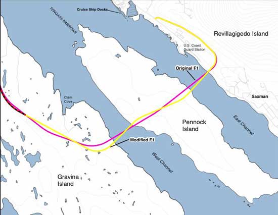
Quoting the August 2004 Gravina Access Project EIS Summary, of the alternatives carried forward for detailed evaluation, crossing the Tongass Narrows via Pennock Island with two bridges (Alternative F1) best satisfies the purpose of and need for the project while minimizing impacts on aviation, navigation, marine habitat, and the local economy. Alternative F1 would:
According to the August 2004 statement, Alternative F1 provides the additional benefit of improved access to Pennock Island, which contains a substantial amount of the borough land base. The Final EIS noted the United States Coast Guard indicated that closing the East Channel to large vessel traffic likely would not meet the reasonable needs of navigation in Tongass Narrows. Alternative F1 is preferable to the other alternatives from a navigation safety standpoint because it would not contribute to conflicts at the navigational choke point next to Ketchikan International Airport and Alaska Ship and Drydock and it would not require additional ship maneuvers, or the increased risk of such maneuvers, for cruise ships transiting the West Channel (as would Alternative F3). In addition, the National Oceanographic and Atmospheric Administration (NOAA), which is proposing to homeport the research vessel Fairweather in Ketchikan at the USCG base, has voiced strong support for an alternative that provides for large vessel transits in the East Channel. Alternative F1 would result in adverse impacts to wetlands and upland habitat; would change the character of Pennock Island, which has historically been a community that values its physical separation from the larger Ketchikan community; and would increase traffic through the downtown core. There are two cultural properties, one on Pennock Island and one on Gravina Island, near Alternative F!. The Pennock Island cultural property includes two cabins on the eastern side of the island. The cultural property on Gravina Island includes a large barge, a cabin, a large engine, and boatway cleared of rocks. DOT&PF and FHWA have determined that these two cultural properties are eligible for placement in the National Register of Historic Places because of their information potential, that they are in the area of potential visual effects by not physical effects, and that Alternative F1 would not affect these properties. The Alaska DOT&PF and the FHWA noted Alternative F1 is preferable to the other alternatives because it would not affect cruise ship access and operations nor would it affect Part 77 airspace. It was also noted to have beneficial impacts by creating a "hard link" (bridge) to Gravina Island and providing access to developable land there. It was noted that Alternative F1 is the most expensive alternative. All reasonable alternatives under consideration - including the No Action Alternative - were developed to a comparable level of detail in the Final EIS and their comparative merits evaluated. Alternative F1 would cross the Tongass Narrows via Pennock Island with two bridges. One bridge would cross the East Channel and the other would cross the West Channel. The East Channel bridge would be approximately 3,610 feet long and have a maximum height of approximately 250 feet. The bridge would have a vertical navigational clearance of 200 feet above high tide and a horizontal navigational clearance of approximately 550 feet. The West Channel bridge would be approximately 2,690 feet long and have a maximum height of approximately 160 feet. The bridge would have a vertical navigational clearance of 120 feet above high tide and a horizontal navigational clearance of approximately 500 feet. Bridge heights over East and West Channels are designed to allow existing vessel traffic in the Tongass Narrows to continue as it does today: cruise ships would use East Channel and other large vessels, such as Alaska Marine Highway System (AMHS) ferries and barge traffic, would continue to use the West Channel, predominantly. A design modification was made to Alternative F1 in response to concerns and comments expressed by marine pilots with regard to the original alignment of Alternative F1. On Revillagigedo Island, Alternative F1 would connect to Tongass Avenue south of Tatsuda's grocery story and near the southern end of the rock quarry. From this terminus, the alignment would rise to the southeast along the hillside (and east of the tank farm, the cemetery, and the above high tide Station), turn westward (skirting the southern end of the USCG Station property, north of the Forest Park Subdivision) and cross over Tongass Avenue approximately 1.4 miles south of downtown Ketchikan, then cross the East Channel to Pennock Island. The roadway would cross Pennock Island at grade. From Pennock Island, the West Channel bridge would cross to Gravina Island, touching down approximately 2.7 miles south of the airport runway. The road would continue northward approximately 5.4 miles to the northern end of the Airport Reserve zone. A 1.2-mile airport access road would be constructed at a grade low enough to accommodate the planned future expansion of the runway, with the runway extended as a overpass of the road. The Final EIS will be available for public review starting August 6th at the Ketchikan Public Library (629 Dock Street); Ketchikan Gateway Borough Planning Office (344 Front Street); DOT&PF (6860 Glacier Highway, Juneau); as well as available online. A notice of availability is anticipated in the Federal Register on August 06, 2004. Written comments on the Final EIS must be received by September 7, 2004. Send all comments to:
The Gravina Access Project Team will be in Ketchikan on Wednesday, August 4th and has scheduled an Open House at the Ted Ferry Civic Center from 11:00 am - 2:00 pm. To talk with the Project Team, view the Final EIS, and/or obtain a copy, the Project Team invites you to attend the Open House. For more information about
the Gravina Access Project visit gravina-access.com.
|