50-Year-Old Mystery Solved: Seafloor Mapping Reveals Cause of 1964 Tsunami that Destroyed Alaskan Village
July 04, 2016
USGS geologists mapping Alaska’s south coast shortly after the 1964 Great Alaska Earthquake had speculated that a submarine landslide might have triggered the Chenega tsunami, just as known landslides triggered tsunamis that devastated the Alaskan towns of Valdez, Seward and Whittier. But “a bathymetric survey at the time, which only imaged relatively shallow seafloor, down to 180 meters (330 feet) deep, did not reveal evidence of a landslide in nearby Dangerous Passage or the other waterways around Chenega. Alternate explanations involving seafloor movement during the earthquake did not fit the timing and severity of the Chenega tsunami as described by eyewitnesses,” explained Daniel Brothers, USGS geophysicist and lead author of the study.
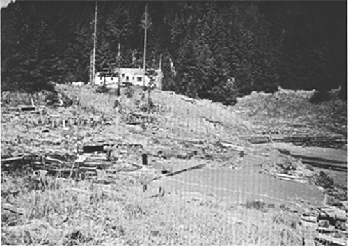
Main part of the Chenega village site at the head of Chenega Cove, Alaska. Piling in ground marks the former locations of homes that were swept away by waves. Schoolhouse on high ground was undamaged. Photograph taken 1964.
“What makes this slide unusual is that much of the material that slid was at a water depth of 250 to 350 meters (820 to 1150 feet),” said Peter Haeussler, USGS geologist and a coauthor of the report. “The deeper initiation depth made it particularly good at generating a tsunami.” The scientists used multibeam sonar technology to collect high-resolution bathymetric (seafloor depth) data, and a single-channel seismic-reflection system to collect sub-bottom profiles (cross-sectional views of sedimentary layers and other features beneath the seafloor). The researchers calculated the time it would take for a tsunami triggered by a large landslide in the mapped areas to reach the village of Chenega and found a good fit with eyewitness reports: a tsunami wave triggered in the areas where they found landslide evidence would take three to four minutes to reach the village, consistent with the arrival time of the most destructive waves.
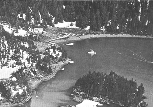
Aerial view of the Chenega village site at the head of Chenega Cove. Lower limits of snow, as shown by arrows, indicate the approximate limits of wave runup; the schoolhouse is circled.
The modern bathymetric data revealed three sedimentary basins at progressively deeper levels toward the open waters of Prince William Sound. These basins were originally carved by descending glaciers when sea level was lower. As sea level rose and the glaciers retreated after the last ice age, the basins filled with sediment eroded and washed off the land. The basins are separated by sills, likely terminal glacial moraines, and bounded by steep, rugged slopes. Details of the underwater terrain include scarps, blocks, hummocky surfaces and other features typical of landslides. Similarly, the sub-bottom seismic profiles show that theGibbons basins are filled with fine-grained sediment, with layers disrupted in ways that indicate multiple landslides. The report by USGS scientists and their colleagues from Boise State University and the Alaska Department of Fish and Game, “A submarine landslide source for the devastating 1964 Chenega tsunami, southern Alaska,” was published in the journal, Earth and Planetary Science Letters in February 2016.
Edited by Mary Kauffman, SitNews
Source of News:
Representations of fact and opinions in comments posted below are solely those of the individual posters and do not represent the opinions of Sitnews.
|
||