Northern Alaska Coastal Erosion Threatens Habitat and Infrastructure
July 16, 2015
“Coastal erosion along the Arctic coast of Alaska is threatening Native Alaskan villages, sensitive ecosystems, energy and defense related infrastructure, and large tracts of Native Alaskan, State, and Federally managed land,” said Suzette Kimball, acting director of the USGS.
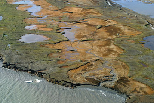
Oblique aerial photograph at Flaxman Island, Alaska showing tapped and untapped thermokarst lakes, caribou tracks, narrow beaches, and bluff failures along the coast. Image taken August 9, 2006, USGS
“This report provides invaluable objective data to help native communities, scientists and land managers understand natural changes and human impacts on the Alaskan coast,” said Ann Gibbs, USGS Geologist and lead author of the new report. Coastlines change in response to a variety of factors, including changes in the amount of available sediment, storm impacts, sea-level rise and human activities. How much a coast erodes or expands in any given location is due to some combination of these factors, which vary from place to place. "There is increasing need for this kind of comprehensive assessment in all coastal environments to guide managed response to sea-level rise and storm impacts," said Dr. Bruce Richmond of the USGS. "It is very difficult to predict what may happen in the future without a solid understanding of what has happened in the past. Comprehensive regional studies such as this are an important tool to better understand coastal change. ” Compared to other coastal areas of the U.S., where four or more historical shoreline data sets are available, generally back to the mid-1800s, shoreline data for the coast of Alaska are limited. The researchers used two historical data sources, from the 1940s and 2000s, such as maps and aerial photographs, as well as modern data like lidar, or “light detection and ranging,” to measure shoreline change at more than 26,567 locations. There is no widely accepted standard for analyzing shoreline change. The impetus behind the National Assessment project was to develop a standardized method of measuring changes in shoreline position that is consistent on all coasts of the country. The goal was to facilitate the process of periodically and systematically updating the results in a consistent manner. The report, titled “National Assessment of Shoreline Change: Historical Shoreline Change Along the North Coast of Alaska, U.S.-Canadian Border to Icy Cape,” is the 8th Long-Term Coastal Change report produced as part of the USGS’s National Assessment of Coastal Change Hazards project. A comprehensive database of digital vector shorelines and rates of shoreline change for Alaska, from the U.S.-Canadian border to Icy Cape, is presented along with this report. Data for all 8 long-term coastal change reports are also available on the USGS Coastal Change Hazards Portal.
Edited by Mary Kauffman, SitNews
Source of News:
|
||