July 12, 2009
"Our fisheries stock assessment teams use the newly gathered data as well as the historic data to help determine the health of the resources and make decisions about future management and fishing activities in the Gulf of Alaska," said Doug DeMaster Director of the Alaska Fisheries Science Center.
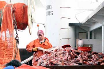
Scientists on the Sea Storm, the Vesteraalen, and the Pacific Explorer plan to complete about 825 survey trawl hauls over a 75-day period along the continental shelf and upper continental slope of the Gulf of Alaska. They started May 18 in Dutch Harbor and expect to end their charters around July 31 in Ketchikan. "The survey tells us trends in the distribution and abundance of important groundfish species such as walleye pollock, Pacific cod, flatfish, and rockfish," said Alaska Fisheries Science Center's Resource Assessment and Conservation Engineering Division Director Russ Nelson. "It also helps us measure various biological and environmental parameters such as sea surface and bottom temperatures and the size, age, and food habits of important groundfish." The survey has been carried out every other year since 1999; between 1984 and 1999 it was completed every three years. Each of the vessels is identified with clearly visible 'NOAA Research' or 'US Research' signs posted on either side of the vessel's superstructure. "Of particular note is the operation of these vessels in southeast Alaska, a region where trawl vessels are not typically seen, during the latter half of July," said Nelson. The three boats started the survey near the Islands of Four Mountains, about 180 miles southwest of Dutch Harbor, and are working their way eastward to the U.S.-Canada border at Dixon Entrance. Each vessel will make 15-minute trawl hauls at specific, randomly pre-selected stations. The trawl catches are sorted, weighed, and enumerated by species. Samples will be collected from selected species to determine fish size and age, sexual maturity, and food habits. A bathythermograph attached to the trawl headrope records data on ocean temperature, and the depth of the survey tows. Sample depths will range from depths greater than 15 meters near shore to 1,000 meters on the continental slope. When the survey is finished, scientists will edit and finalize the data they collected on fishing effort, catch rates, and fish size distribution and generate fishery-independent estimates of geographic and depth distribution, abundance, and population size composition by the end of September. Stock assessment modelers will then combine that information with data from the fishery and results of previous surveys to update the stock assessments used by the North Pacific Fishery Management Council to manage the groundfish stocks of the Gulf of Alaska. Each of the three boats carries six researchers plus the skipper and a crew of four. In addition to staff scientists from NOAA's Alaska Fisheries Science Center, researchers are also participating from the International Pacific Halibut Commission, Oregon State University, the University of Washington, and the Virginia Institute of Marine Science.
Source of News:
Publish A Letter in SitNews Read Letters/Opinions
|
||