July 12, 2005
Scientists on the Sea Storm, the Gladiator, and the Northwest Explorer are expected to complete about 800 survey trawl hauls over an 80-day period along the continental shelf and upper continental slope of the Gulf of Alaska. They started May 18 in Dutch Harbor. The Gladiator will end its 65-day charter in Kodiak around July 21. The other two vessels are expected to end their charters in early August in Ketchikan. "This biennial survey tells us trends in the distribution and abundance of important groundfish species such as walleye pollock, Pacific cod, flatfish and rockfish" said Alaska Fisheries Science Center's Resource Assessment and Conservation Engineering Division Director Gary Stauffer. "It also helps us measure various biological and environmental parameters such as sea surface and bottom temperatures and the size, age, and food habits of important groundfish." The survey has been carried out every other year since 1999 - before then, it was every three years, starting in 1984. The three boats started the
survey near the Islands of Four Mountains, about 180 miles southwest
of Dutch Harbor, and will work their way eastward to the U.S.-Canada
border at Dixon Entrance. Cruise breaks for all three vessels
will occur in Sand Point, Kodiak, and Seward. Each of the vessels
is identified with clearly visible "NOAA Research"
placards. Of particular note is the operation of the Sea Storm
and Northwest Explorer in southeast Alaska, a region where trawl
vessels are not typically seen. These two vessels will be surveying
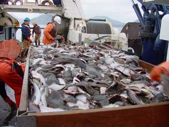
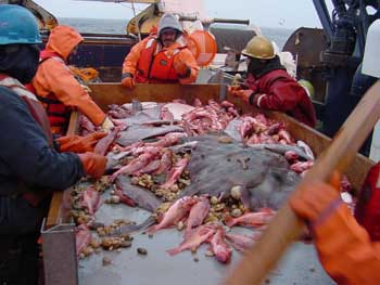
southeast Alaska from mid-July to early August. Each vessel will make 15-minute trawl hauls at specific, randomly pre-selected stations. The trawl catches are sorted, weighed, and enumerated by species. Samples will be collected from selected species to determine fish size and age, sexual maturity, and food habits. Data on the temperature of the ocean and depth of the survey tows are recorded using a 'bathythermograph' attached to the trawl headrope. Sample depths will range from depths greater than 15 meters near shore to 1,000 meters on the continental slope. Each of the three boats holds six researchers plus the skipper and crew. Participating researchers are from the Alaska Fisheries Science Center, the California Academy of Sciences, the International Pacific Halibut Commission, the University of Washington, the Seward Sea Life Center, and the Moss Landing Marine Laboratory (Moss Landing, California).
Source:
Publish A Letter on SitNews Read Letters/Opinions Submit A Letter to the Editor
|
||