 50th anniversary of the 1953 Mt. Spurr eruption July 16, 2003
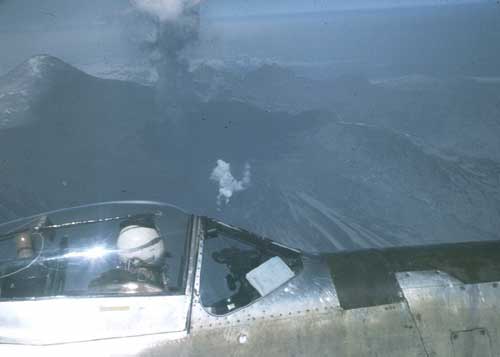
It took more than 170,000 gallons of water to hose off the Merrill airfield, and the city's street sweepers worked non-stop for 3 days. Winds repeatedly allowed the re-suspension of ash, prolonging residents' discomfort as they struggled to clear local roads, buildings and the airport. Local commerce was at a standstill, but in the words of the Anchorage Daily News, residents of the young frontier city exhibited a "calm and resigned attitude." Relief finally came 3 weeks later when nearly an inch of rain fell, washing the city and stabilizing the ash. July 9th marks the 50th anniversary of this sudden and dramatic eruption of Crater Peak, the active vent on Mount Spurr volcano. At the time of this eruption, scientists were unaware that an eruption was imminent, nor did they fully comprehend the hazards associated with such an eruption. Now, fifty years later, volcano monitoring has improved substantially, helping save lives, health and property. By the summer of 1992, when three closely spaced eruptions similar in scale to the single 1953 eruption occurred at Crater Peak, scientists at the Alaska Volcano Observatory (AVO) were able to warn communities and the aviation industry before the eruption. The AVO is a collaborative scientific program formed in 1988 among the U.S. Geological Survey, the University of Alaska Geophysical Institute, and the Alaska Division of Geological and Geophysical Surveys. Residents were more prepared as the 1992 August ash cloud drifted southeastward, blanketing Anchorage, Prince William Sound, and the southeastern shoreline of the Gulf of Alaska with ash, plunging the city once again into premature darkness. 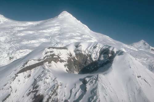
"Today," said Tom Murray, USGS Scientist-in-Charge of AVO, "in the event of an eruption at Mount Spurr or any other Alaskan volcano, scientists at the Alaska Volcano Observatory are prepared to respond immediately by issuing eruption notifications and reports of seismic unrest and potential hazards to aviators and emergency management officials." Scientific understanding of volcanic hazards, processes and eruptions has also greatly improved in the last 50 years. USGS work in the Cook Inlet region has identified at least 15 deposits of volcanic ash originating from Mount Spurr volcano over the last 2000 years. Based on this work, said Murray, a future eruption as large as or larger than the eruptions in 1953 and 1992 is certain. Volcanic hazards from eruptions of Crater Peak are principally airborne ash, pyroclastic flows generated by the collapse of the eruption column near the volcano, and volcanic debris flows, or lahars, which are generated by significant melting of glaciers causing sometimes massive flows of water-saturated rock debris. Lahars, in fact, have dammed the Chakachatna River, downstream from the volcano, multiple times during the last 10,000 years. Breaching of these dams poses a significant flood hazard to areas along the Chakachatna River. The greatest hazard posed by eruptions is airborne ash and associated ashfall, said Murray. Individual ash particles are hard and do not dissolve in water. Volcanic ash consists of tiny jagged particles of rocks, minerals and natural glass; it is abrasive, mildly corrosive, and conducts electricity when wet. 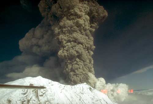
The risk to aviation was dramatically demonstrated in December 1989, when an ash cloud from an eruption of Redoubt Volcano, 109 miles from Anchorage, disabled all four engines of a Boeing 747 during its descent into Anchorage. After dropping 2 miles in altitude, the crew was able to restart the engines and land safely, though the airplane was seriously damaged. This is just one example of the numerous reported aircraft-ash encounters in the North Pacific since 1980. Airborne ash can diminish visibility, damage flight control systems and may cause engine failure. Even minor amounts of ash can cause aircraft damage, create health problems, close roads and airports, disrupt utilities, and temporarily contaminate water supplies for hundreds of miles downwind of the volcano. Adding to the threat for aircraft is that volcanic ash clouds are difficult to distinguish from ordinary clouds, both visually and on radar, and ash clouds can drift thousands of miles from their source. In addition to the ash threat for aircraft, volcanic ash poses other hazards, including:
In response to these potential hazards, federal and state agencies worked together to develop a system of eruption warning and detection, as well as ash cloud tracking and forecasting. This system, noted Murray, not only requires scientific expertise, but it also requires effective working relationships among volcano observatories, meteorological and civil aviation authorities and emergency managers. Participants in the system include the USGS, Alaska Volcano Observatory, the Federal Aviation Administration, the National Weather Service, the Alaska Division of Emergency Services, the U.S. Air Force, and soon, the U.S. Coast Guard. Mount Spurr volcano is on the northwest side of Cook Inlet, 80 miles west of Anchorage in the eastern Aleutian volcanic arc of Alaska. It is the one of four active volcanoes in the Cook Inlet region, Alaska's most populated region. Alaska has more than 40 active volcanoes and there have been more than 250 eruptions since historical records were kept starting in 1760. The Cook Inlet volcanoes (Spurr, Redoubt, Augustine, and Iliama) alone have erupted 12 times since 1900. 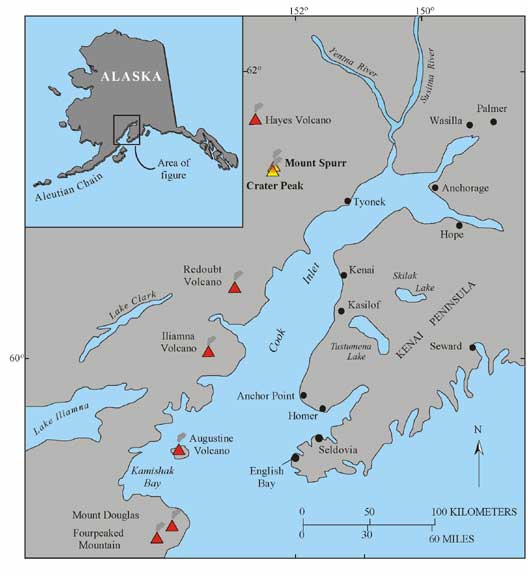
For more information about Alaskan volcanoes visit these web sites:
Story & photographs courtesy:
Stories In The News Ketchikan, Alaska |