
Gravina Access Project Open House and Hearing
|
|||
Gravina Access Project Draft SEIS Open House and Public Hearing Wednesday, July 17, 2013 11 am–5 pm - Open House, 5 pm–8 pm - Public Hearing Ted Ferry Civic Center, 8 888 Venetia Avenue, Ketchikan, AK |
The purpose of the Gravina Access Project is to improve surface transportation between Revillagigedo (Revilla) Island, home of the Ketchikan Gateway Borough, City of Ketchikan and the City of Saxman, and Gravina Island, the location of the Ketchikan International Airport and adjoining lands that offer recreational and development potential.
The opening of the Gravina Island Highway also provides access to some private lands and the Ketchikan Gateway Borough’s developable lands north and south of the airport reserve, and to the Bostwick Lake Road and the Alaska Department of Natural Resources and the U.S. Forest Service’s timber lands. According to information provided the Alaska Department of Transportation,, the need for improving access is threefold:
- To provide the Ketchikan Gateway Borough and its residents more reliable, efficient, convenient, and cost-effective access for vehicles, bicycles, and pedestrians to Borough lands and other developable or recreational lands on Gravina Island in support of the Borough’s adopted land use plans.
- To improve the convenience and reliability of access to Ketchikan International Airport for passengers, airport tenants, emergency personnel and equipment, and shipment of freight.
- To promote environmentally sound, planned long-term economic development on Gravina Island.
The Alaska Department of Transportation and Public Facilities (ADOT&PF) made the new 2013 Gravina Access Project Draft Supplemental Environmental Impact Statement (SEIS) available today for public review and comment. During the 45-day comment period, the public has a right to provide feedback through written comments or through public hearing statements. Comments may be the most important contribution from citizens. The 45 day public comment period will close August 13, 2013.
The Alaska Department of Transportation, in cooperation with the Federal Highway Administration (FHWA), developed the Gravina Access Project to improve public access between Revillagigedo Island and Gravina Island. In 2004, the department and Federal Highway Administration issued a Final Environmental Impact Statement identifying a preferred alternative that would require two bridges across the Tongass Narrows at Pennock Island. The 2004 Final Environmental Impact Statement (FEIS) examined nine build alternatives and the No Build Alternative. The nine build alternatives included six bridge alternatives and three ferry alternatives. The Final EIS which was distributed to the public and federal and state agencies on July 30, 2004, identified Alternative F1 as the FHWA’s and DOT&PF’s Preferred Alternative. Alternative F1, selected in 2004, would have crossed Tongass Narrows via Pennock Island with two bridges: a 200-foot bridge over the East Channel and 120-foot bridge over the West Channel. FHWA issued a Record of Decision on September 15, 2004, and identified Alternative F1 as the Selected Alternative. However, three years later, in 2007, then-Governor Sarah Palin directed the department to look for the most fiscally responsible alternative instead of proceeding any further with the project which was estimated around $375 million. Given the change in the proposed action, the Alaska Department of Transportation was then required to prepare a new SEIS in order to propose a new course of action.
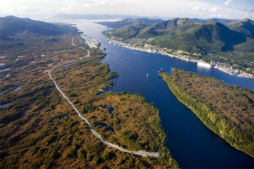
Gravina Island Highway
Photo courtesy ADOT&PF
Although the F1 project was halted, the 2004 Preferred Alternative F1 included a road segment on Gravina Island to connect the bridge over West Channel to the Airport Access Road. The road segment, referred to as the Gravina Island Highway, started approximately 3.4 miles south of the airport runway and continued north to the intersection of the Airport Access Road and Lewis Reef Road. The DOT&PF had moved forward with construction of the Gravina Island Highway prior to Governor Palin’s announcement and completed construction of the highway in the fall 2008. The Gravina Island Highway is now open and provides public access to lands on Gravina Island.
Now in 2013, during the new process, the department has identified six "reasonable" build alternatives in the new Draft SEIS, which comprise of two bridge and four ferry options that would improve access to Gravina Island from Ketchikan. The department will now review and use the public’s comments as a basis for selecting a preferred alternative access to include in the Final SEIS.
The Federal Highway Administration and Alaska Department of Transportation reviewed the 2004 Gravina Access Project Final Supplemental Environmental Impact Statement and previous engineering studies, conducted engineering and environmental studies, and obtained input from the Ketchikan community; local, state, and federal agencies; Tribal governments; and other Native organizations to develop the 2013 project alternatives (Click here for the 2013 alternatives map):
• No Action Alternative
• 2 Bridge alternatives (C3-4 and F3)
• 4 Ferry alternatives (G2, G3, G4, and G4v)
No Action Alternative: Continued operation of existing airport ferry
"Under the No Action Alternative, no bridge would be constructed and no additional ferry service would be provided between Revillagigedo Island and Gravina Island. The only public access between the two islands would continue to be provided by the existing airport ferry service across Tongass Narrows, private boats, and floatplanes. On Revillagigedo Island, the existing ferry terminal is located 2.8 miles north of downtown Ketchikan; on Gravina Island, the terminal is on the waterfront, just east of the airport terminal. The Borough operates the airport ferry service. The ferry service would continue to operate 16 hours per day and the frequency of service would remain the same, with departures every 30 minutes in winter and every 15 minutes in summer." (Gravina Access Project Draft Supplemental Environmental Impact Statement, Chapter 2, Alternatives)
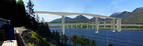
Alternative C3-4
Graphic courtesy ADOT&PF
Alternative C3-4 – Airport Bridge with 200 feet of vertical navigational clearance. The construction costs in 2008 dollars is estimated $240 million.
"Alternative C3-4 would include construction of a road along a topographic bench on Revillagigedo Island connecting to Rex Allen Drive/Misty Marie Lane/Signal Road near Wal-Mart and a bridge across Tongass Narrows touching down on Gravina Island near the airport terminal. The Alternative C3-4 bridge would be approximately 4,190 feet long and total length of the alternative would be 1.9 miles. It would include an 8-foot-wide walkway on the bridge structure, which can be used by pedestrians and bicycles. The maximum height of the bridge over the navigational channel would be approximately 280 feet above mean higher high water (MHHW), which would penetrate FAA Part 77 airspace. The vertical navigational clearance would be 200 feet above MHHW. The horizontal navigational clearance would be 550 feet. These navigational clearances would accommodate one-way passage of cruise ships and two-way passage of most other ships, including Alaska Marine Highway System (AMHS) ferries." (Gravina Access Project Draft Supplemental Environmental Impact Statement, Chapter 2, Alternatives)
Alternative F-3
Graphic courtesy ADOT&PF
Alternative F3 – Pennock Island bridges with 60 feet of vertical navigational clearance over the East Channel and 200 feet of vertical navigational clearance over the West Channel. The construction costs in 2008 dollars is estimated $304 million.
"Alternative F3 is approximately 5.9 miles long and would cross Tongass Narrows with two bridges via Pennock Island. The access would begin at South Tongass Highway south of the U.S. Coast Guard Station and cross the East Channel to Pennock Island and the West Channel to Gravina Island. The East Channel bridge would be approximately 1,985 feet long and have a maximum height of approximately 115 feet above MHHW. The bridge would have a vertical navigational clearance of 60 feet above MHHW and a horizontal clearance of approximately 350 feet. These clearances would not accommodate cruise ships, AMHS ferries, or tall freight barges that currently use the East Channel as their primary navigational route. The primary users of the East Channel are anticipated to be smaller tugs and barges, and commercial and recreational vessels with air drafts less than 60 feet. The West Channel bridge would be approximately 2,470 feet long and have a maximum height of approximately 270 feet above MHHW. The bridge would have a vertical navigational clearance of 200 feet above MHHW and a horizontal navigational clearance of approximately 550 feet, which would accommodate one-way passage of cruise ships and two-way passage of most other ships, including AMHS ferries. Both bridge structures would include an 8-foot-wide walkway, which can be used by pedestrians and bicycles. Neither bridge would penetrate FAA Part 77 airspace. This alternative requires dredging the West Channel to improve its navigational characteristics. The dredged quantity is approximately 213,000 cubic yards over approximately 15 acres." (Gravina Access Project Draft Supplemental Environmental Impact Statement, Chapter 2, Alternatives)
Alternative G2 - New ferry between Peninsula Point and Lewis Point; continued operation of existing ferry
"Alternative G2 would be a new ferry service that would complement the existing airport ferry for vehicles and passengers between Peninsula Point on Revillagigedo Island and Lewis Point on Gravina Island. This alternative would cross Tongass Narrows approximately 2.0 miles north of the airport passenger terminal and would have a sailing distance of approximately 0.8 miles. Two new ferry vessels and construction of a new ferry terminal on each side of Tongass Narrows would be required for this alternative. A 0.8-mile-long road would be constructed on Gravina Island to connect the ferry terminal at Lewis Point with Seley Road." (Gravina Access Project Draft Supplemental Environmental Impact Statement, Chapter 2, Alternatives)
Alternative G3 - New ferry between Downtown and south of airport; continued operation of existing ferry
"Alternative G3 would be new ferry service that would complement the existing airport ferry for vehicles and passengers between downtown Ketchikan at Jefferson Street (near the Plaza Mall at Bar Point) on Revillagigedo Island and a location approximately 1.3 miles south of the airport passenger terminal on Gravina Island near Clump Cove. The crossing distance would be approximately 1.3 miles. This alternative would require construction of a new ferry terminal on each side of Tongass Narrows and two new ferry vessels. Dredging may be required to provide adequate navigational depth for the ferry terminal on Revillagigedo Island. The existing breakwater could also be widened and extended for use as the ferry terminal pier. A paved road would be constructed on Gravina Island from the ferry terminal past the new Runway 11/29 extension approximately 0.2 miles to the Gravina Island Highway." (Gravina Access Project Draft Supplemental Environmental Impact Statement, Chapter 2, Alternatives)
Alternative G4 - New ferry adjacent to existing ferry; continued operation of existing ferry
"Alternative G4 would be new ferry service for vehicles and passengers adjacent to the existing airport ferry route between Charcoal Point on Revillagigedo Island and the existing ferry lay-up berth on Gravina Island on a quarter-mile crossing of Tongass Narrows, approximately 2.6 miles north of downtown. This alternative would require two new ferry vessels and construction of a new ferry terminal on each side of Tongass Narrows adjacent to the existing airport ferry terminals." (Gravina Access Project Draft Supplemental Environmental Impact Statement, Chapter 2, Alternatives)
Alternative G4v - Continued operation of existing ferry with improved shoreside amenities
"Alternative G4v was added as a lower cost alternative to Alternative G4 because it provides shoreside facilities to improve the convenience of airport travelers and heavy freight movement, but does not add new ferries or ferry terminals until ferry demand increases enough to warrant the additional capacity. Such demand is not anticipated in the 75-year design life of this alternative." (Gravina Access Project Draft Supplemental Environmental Impact Statement, Chapter 2, Alternatives)
As per a request by Alaska Department of Transportation, bridge alternatives were evaluated with and without tolls to offset, in part, the cost of bridge construction and operation.
All ferry alternatives include:
• A 60-passenger waiting facility and other improvements to the terminal site on Revillagigedo Island.
• Two shuttle vans to carry both pedestrians and their luggage from Revillagigedo Island to the airport terminal on Gravina Island.
• A new heavy freight dock on Gravina Island for highway loads that cannot be accommodated by the shuttle ferry.
• Reconstruction of the existing airport ferry transfer bridges and ramps.
• Upgrades and improvements for all sidewalks and wheelchair ramps associated with the airport ferry facilities to meet applicable standards.
• Toll facilities.
• Replacement of the existing ferry layup dock and transfer bridge to support layup and maintenance of the airport shuttle ferry system.
Each action alternative includes the maintenance and operation of:
• The recently constructed Gravina Island Highway;
• Lewis Reef and Seley roads to the northern airport reserve boundary; and
• Airport Access Road, which extends from the airport terminal to its intersection with the Gravina Island Highway and Lewis Reef Road.
Each action alternative also includes replacement of the existing 24-foot wide bridge over Airport Creek (west fork) at the end of Lewis Reef Road with a new 36-foot wide bridge. The existing Airport Creek bridge is a temporary structure constructed by a private entity for access to land in the Lewis Reef development area. While the creek crossing was authorized by FHWA as part of Alternative F1, it was not included in the first phase of construction by DOT&PF. Although Alternative F1 had been selected by FHWA in the 2004 Record of Decision and identified and permitted as the LEDPA by USACE, it was not carried forward as a reasonable alternative in the SEIS because its construction costs were estimated to exceed available funding. Under the USACE permit for Alternative F1, a total of 82.2 acres of permanent fill were permitted and DOT&PF provided $405,000 of compensatory mitigation as a fee in lieu type of mitigation. With completion of Phase 1 (i.e., construction of the Gravina Island Highway), 54.3 acres of wetlands had been filled and DOT&PF had paid the compensatory mitigation to the Southeast Alaska Land Trust. The USACE permit expired June 30, 2011.
The Draft SEIS will be available online at the Gravina Access Project website. Printed copies may be found at the Ketchikan Gateway Borough, City of Ketchikan and City of Saxman offices; the Ketchikan Indian Community and Organized Village of Saxman offices; and the Ketchikan and Metlakatla public libraries. ADOT&PF Southeast Region will also have a printed copy available in Juneau.
Public comments may be submitted via the online comment form on the project website. Comments submitted by mail, fax and email will also be accepted.
In drafting comments, it is suggested that the public focus on the purpose and need of the proposed action, the proposed alternatives, the assessment of the environmental impacts of those alternatives, and the proposed mitigation. Commenting is not a form of “voting” on an alternative; rather it is means of providing additional information to the agencies involved in making decisions about the project.
A decision is expected to be made in the Spring of 2014.
To Provide Written Comment:
Online:
Submit Comments
http://dot.alaska.gov/sereg/projects/gravina_access/feedback.shtml
E-mail Comments:
Mail comments to:
Gravina Access Project SEIS DOT&PF
P.O.Box 112506,
Juneau, AK 99811-2506
On the Web:
Gravina Access Project: Draft EIS Summary ( pdf 16 pages)
http://dot.alaska.gov/sereg/projects/gravina_access/assets/
Draft_EIS/Draft_SEIS_Summary.pdf2013 Reasonable Alternatives Draft Map
http://dot.alaska.gov/sereg/projects/gravina_access/images/
alternatives_11x17_draft_v3.pdfGravina Access Project Documents
http://dot.alaska.gov/sereg/projects/gravina_access/documents.shtml
E-mail your news &
photos to editor@sitnews.us
Publish A Letter in SitNews
SitNews ©2013
Stories In The News
Ketchikan, Alaska
Articles & photographs that appear in SitNews may be protected by copyright and may not be reprinted without written permission from and payment of any required fees to the proper sources.