
Melting glaciers boost sea level;
however, sea levels will actually drop in Alaska
By MOLLY RETTIG
June 08, 2013
Saturday
(SitNews) - Every summer, Alaska’s glaciers melt and send vast quantities of water gushing through silty gray rivers, past towns and villages and finally into the sea. Some glaciers calve directly into the ocean, instantly losing car-sized chunks of ice and wowing boats full of tourists.
The world's melting glaciers are boosting ocean levels 0.71 millimeters a year, accounting for roughly one-third of total sea level rise, according to a recent study.
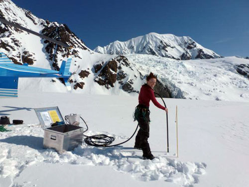
Graduate student Joanna Young drills a hole into the Susitna Glacier for a weather station and a melt stake which was installed in April 2012.
Photo by R. Hock.
“That's the equivalent of draining the Great Lakes once a month each year,” says Regine Hock. She and colleague Anthony Arendt, both glaciologists at the University of Alaska Fairbanks Geophysical Institute, just contributed to an article in Science on the role of glaciers in sea level rise.
Alaska and Canada comprise nearly half of that—purging 100 gigatons of mass annually from frozen storage into the ocean.
The mass loss, which scientists call wastage, is so massive that it changes the earth’s gravity field and alters ocean currents around Alaska. So heavy that parts of the earth can bounce up several centimeters in response.
The scientists worked with an international team to calculate the ice loss of glaciers around the world from 2003-2009 using satellite data and ground measurements.
“When many people think about sea level rise, they only think about the big ice sheets in Greenland and Antarctica. They don't think these smaller ones can contribute anything,” says Hock.
The other two-thirds of total sea level rise come from equal parts melting ice sheets and the warming and expansion of oceans. Overall, oceans have risen 2.5 millimeters a year since 2003.
“In 10 years, that's an inch. That's quite a lot,” says Hock.
It trickles in from the state's favorite glaciers--Gulkana in the Alaska Range, Exit in Seward, Portage on the Kenai Peninsula, Mendenhall in Juneau, Columbia on Prince William Sound, and all throughout the Wrangell mountains.
Where does it go?
“Most of the meltwater ends up in streams and eventually makes its way to the oceans,” Hock says.
This affects not just the ocean but the overall hydrology of the earth. Communities in the Andes, for example, rely on glacial runoff for water in the summer dry season. The more ice that's lost, the smaller their water source.
Glacier water is cold and fresh, which affects the temperature and chemistry of rivers and oceans—and can impact fisheries and ecosystems.
“Salmon and other species are really sensitive to stream composition. If the temperature changes just a few degrees, that might affect whether salmon can spawn,” Arendt says.
Glacier mass changes have traditionally been estimated by field measurements of individual glaciers.
“It's really old school,” Arendt says.
Scientists dig a snow pit in the winter and measure the snow accumulation, calculate its density, and then convert it to water equivalent. This tells them the annual growth of the glacier.
To calculate melting, they drill a stake into the ice at the beginning of summer and measure the height sticking above the surface. An end-of-summer measurement reveals how much was lost. This depth is converted to water equivalent and extrapolated to the whole basin.
The melt has greatly outpaced the snowfall, according to these observations.
But because of logistics, there are only a handful of such field sites over Alaska’s vast ice-covered region.
To capture broader changes, the new study combined conventional field measurements with satellite data.
One tool was measuring the gravitational force exerted by glaciers.
From Newton, we know that greater mass means larger gravitational force. When a satellite crosses a large mass (like an ice sheet) it speeds up a little because of the greater force. Over areas with less mass, the satellite slows down. By tracking satellite positions over time, you can estimate changes in the ice sheet.
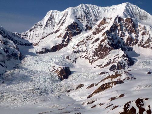
The upper reaches of the Susitna Glacier in the Alaska Range.
Photo by R. Hock.
They learned the volume loss by measuring the distance between a satellite and the glacier.
“You bounce a laser off the surface and it tells you the height. You come back at a later time and map that height again,” says Arendt.
What does this mean for the world—and Alaska?
Some coastlines will be hit harder than others, depending on which glacier regions melt the most.
Sea levels will actually drop in Alaska, as the weight of glaciers is lifted and the earth rises relative to the water.
“As the glaciers disappear, and you take off that load, it allows the earth's crust to rebound in response,” Hock says.
Smaller glaciers, like those in the Brooks Range, will disappear faster than bigger, high-elevation glaciers like those on St. Elias. As glaciers shrink, so could tourism.
Understanding glacier wastage can help predict flooding in river communities and plan energy projects.
"With hydropower coming online, these companies need to know how much water will be transported into these watersheds and how that will change in the future," Hock says.
On the Web:
"A Reconciled Estimate of Glacier Contributions to Sea Level Rise: 2003-2009"
http://www.sciencemag.org/content/340/6134/852.full.pdf?sid=582d6c3d-63a3-4649-8924-6d4b0b24c5ff
Since the late 1970s, the University of Alaska Fairbanks’ Geophysical Institute has provided this column free in cooperation with the UAF research community.
Molly Rettig [molly.rettig@gi.alaska.edu] is a science writer at the institute.
E-mail your news &
photos to editor@sitnews.us
Publish A Letter in SitNews
Contact the Editor
SitNews ©2013
Stories In The News
Ketchikan, Alaska
|
Articles &
photographs that appear in SitNews may be protected by copyright
and may not be reprinted without written permission from and
payment of any required fees to the proper sources.
|
|