 June 08, 2006
Mission managers tested the flight and ground system performance of the satellite's Cloud-Profiling Radar in late May, and found it to be working perfectly, according to a June 6 press release from the NASA Jet Propulsion Laboratory (JPL) in California. "CloudSat's radar performed flawlessly, and although the data are still very preliminary, it provided breathtaking new views of the weather on our planet," said Graeme Stephens, CloudSat principal investigator and a professor at Colorado State University. 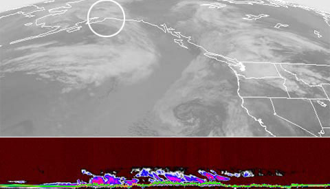 The first images from NASA's new CloudSat satellite are already revealing never-before-seen 3-D details about clouds. Photo courtesy NASA
The NASA team plans to release its first data to the science community within nine months. CloudSat is managed by JPL, which developed the radar instrument with hardware contributions from the Canadian Space Agency. The U.S. Air Force and U.S. Department of Energy contributed resources to the CloudSat program, and U.S. and international universities and research centers support the mission science team. CloudSat was launched along with NASA's Cloud-Aerosol Lidar and Infrared Pathfinder Satellite Observations satellite. Both satellites will orbit 705 kilometers above Earth aboard NASA's constellation of five Earth Observing System satellites. The satellites will work together to provide new insights into the global distribution and evolution of clouds to improve weather forecasting and climate prediction. Just 30 seconds after radar activation, CloudSat obtained its first image -- a slice of the atmosphere from top to bottom that showed a warm storm front over the North Sea in the North Atlantic approaching Greenland. Unlike other satellite observations, the CloudSat radar image shows the storm's clouds and precipitation at the same time. The front's warm air can be seen rising over colder air, with precipitation below. The remaining orbits of the test recorded unique observations of other weather types on a scale never seen before. "We're no longer looking at clouds like images on a flat piece of paper," said Deborah Vane, CloudSat deputy principal investigator at NASA's Jet Propulsion Laboratory, "but instead we're peering into the clouds and seeing their layered complexity." The radar obtained first-time observations of clouds and snowstorms over the Antarctic. Until now, clouds have been hard to observe in polar regions using satellite remote sensing, particularly during the extended darkness of winter. The CloudSat observations also provided new views of sloping, frontal clouds and thunderstorms over Africa, as individual storms and as part of larger tropical storm systems. CloudSat's Cloud-Profiling Radar is more than 1,000 times more sensitive than typical weather radar. It can observe clouds and precipitation in a way never before possible, distinguishing between cloud particles and precipitation. Its measurements are expected to offer new insights into how fresh water is created from water vapor and how much of this water falls to the surface as rain and snow.
|