
Heather Best (in water), a U.S. Geological Survey hydrologist, prepares to toss a road-grader blade with a river-measuring device attached into the Yukon River near Eagle, Alaska. USGS hydrologic technician Liz Richards watches for icebergs. |
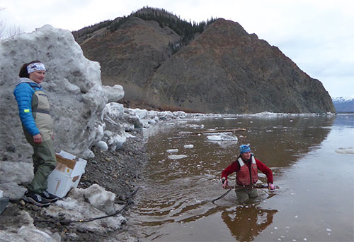
That hunk of steel held the business end of a device Best and others use to measure the flow of the Yukon River at Eagle, a town of about 110 people just downstream of the Canada border.
A few days earlier, ice formed by the cold air of winter had knocked the river-measuring instrument offline. During river breakup at Eagle, rising meltwater lifted a sheet of ice that had been in place most of the winter.
Brown water then ferried immense shards of ice downstream at about 5 miles per hour. Some of it crashed into the bank on an outer river bend just down from Eagle. Those icebergs ripped the river-measuring hose from the shore where it entered the river, shearing it in a few places.
Best and USGS hydrologic technician Liz Richards had driven from their office in Fairbanks to see if they could fix the instrument. They stopped at other waterways during the 10-hour journey, to see if stream information being sent to the internet was accurate and fix things that got dinged up as winter’s ice turned to water.
On the shoreline of the Yukon River, after an hour’s work that included scrambling over ice chunks large as pickups, Best and Richards had spliced the measuring tube where the ice severed it. They reattached it to the grader blade. Then came the trickiest part — the redeployment of the tube beneath the surface of the Yukon.
Trying to keep her time immersed in ice water to a minimum, Best sidestepped out on rocks she couldn’t see beneath the surface. Once the river reached the belt around her waist, she stopped.
Best heaved the grader blade as far as she could into the water. She then retreated toward the shore.
Liz Richards, a USGS hydrologic technician, pulls an anchor attached to a river-level measuring device from the Yukon River just downstream of Eagle, Alaska. |
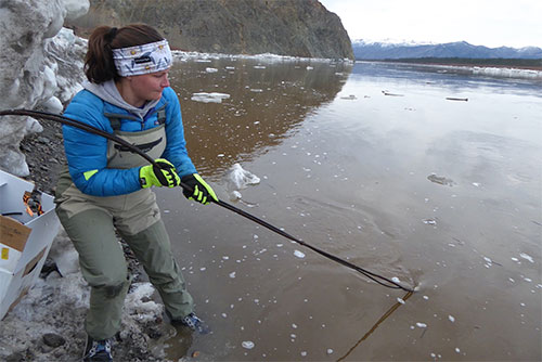
“Nice work,” Richards said from a sliver of gravel shoreline in front of a pile of ice.
“I hope it’s deep enough,” Best said.
The submerged end of a hose would release bubbles of nitrogen into the river in a complicated, somewhat magical system that converts sensed water pressure at the opening of the underwater hose to river depth.
Best said the underwater end had to be deep enough to stay submerged in the coming weeks. If not, she or someone else would have to come back in midsummer, after the river level dropped, to throw the grader blade a little deeper.
“We need it to be at least 4 feet deep,” she said.
Carrying bits of broken hose and a cardboard box of equipment and tools, Best and Richards toed into a steep slope, reaching a small cedar cabin on a grassy bench near the National Park Service field station in Eagle.
Inside the structure were the plastic pipes, glass bulbs and nitrogen tanks that make up the “Conoflow gas-purge system,” a staple of USGS river-and-stream measuring sites around the country.
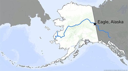
A map shows the location of the town of Eagle, near the border with Canada, and the course of the Yukon River. |
After a little fiddling with the system, Best had good news.
“It looks like it’s in 5 feet of water,” she said.
“Yay,” Richards said.
The women then tidied the little shelter. Best shut the door and padlocked it, and the pair walked to their car, which would take them a few hundred feet to their room with a view of the big river. They would drive out of Eagle on the Taylor Highway the next day, doing a bit more fieldwork on the way home.
As for the town of Eagle, the geese kept passing over in mixed flocks, songbirds flooded the local aspens and people mentioned seeing the first returning swallows.
The river, almost free of ice but soon to swell with meltwater from winter’s snow still in the mountains of Canada and Alaska, once again had its level visible to people far from Eagle, on the USGS website at https://on.doi.gov/3lkbjTL.
Edited By: Mary Kauffman, SitNews
Source of News:
Representations of fact and opinions in comments posted are solely those of the individual posters and do not represent the opinions of Sitnews.
Send a letter to the editor@sitnews.us
SitNews ©2022
Stories In The News
Ketchikan, Alaska
Articles & photographs that appear in SitNews are considered protected by copyright and may not be reprinted without written permission from and payment of any required fees to the proper freelance writers and subscription services.
E-mail your news & photos to editor@sitnews.us
Photographers choosing to submit photographs for publication to SitNews are in doing so granting their permission for publication and for archiving. SitNews does not sell photographs. All requests for purchasing a photograph will be emailed to the photographer.