April 2013 Alaska Weather SummaryPrecipitation, temperature and snowfall records set in April
May 23, 2013
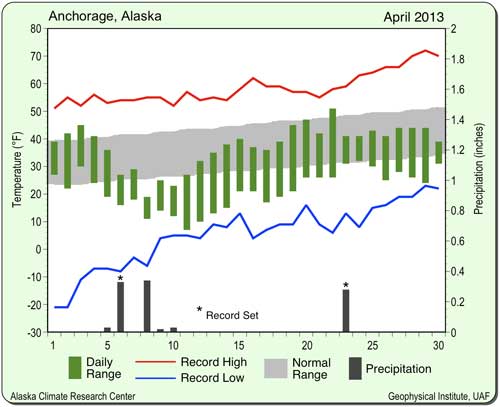
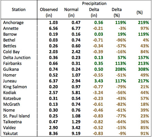
The station with the greatest deviation was Delta Junction at minus 15.2 degrees Fahrenheit below normal. Fairbanks followed with minus 14.6 degrees, as well as Anchorage with minus 7.2 degrees. The mean deviation for all stations was a significant minus 6.3 degrees Fahrenheit. Fairbanks had the third coldest April on record, Anchorage the sixth. Cold Bay was the station reporting the smallest deviation of just -0.2°F. Four record high events experienced by Cold Bay during the month kept the monthly mean temperature near to normal. Precipitation was mixed around the state, with four of nine stations reporting below normal totals. The remaining five stations exceeded precipitation levels. Expressed as percentages, Anchorage reported the greatest positive deviation with 119 percent above normal, followed by Juneau with 117 percent and Fairbanks with 113 percent. King Salmon was the relatively driest station with just 21 percent of the normal amount of precipitation. The mean deviation of all nine stations was 23 percent above normal.
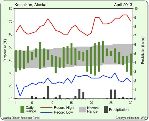
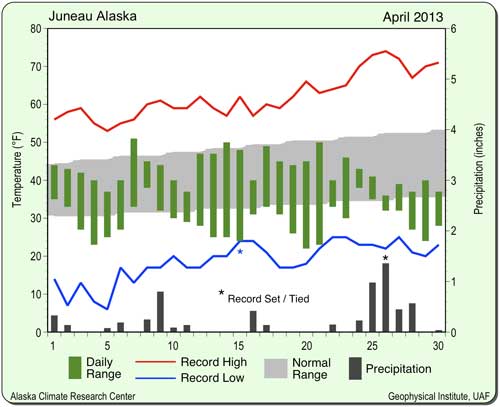
Ketchikan's precipitation was light in April, totaling 7.53 inches. This was 80 percent of the long-term mean of 9.38 inches. The average temperature in Juneau for April was 36.1 degrees Fahrenheit, 4.7 degrees below the long-term mean of 40.8 degrees. The maximum temperature of the month was 51 degrees on the 7th. The month’s minimum temperature was 22 degrees that occurred on the 20th. A low of 24 degrees Fahrenheit was experienced April 15 and tied the record set in 2005. Temperatures were varied, but tended below normal for nearly all of the month.
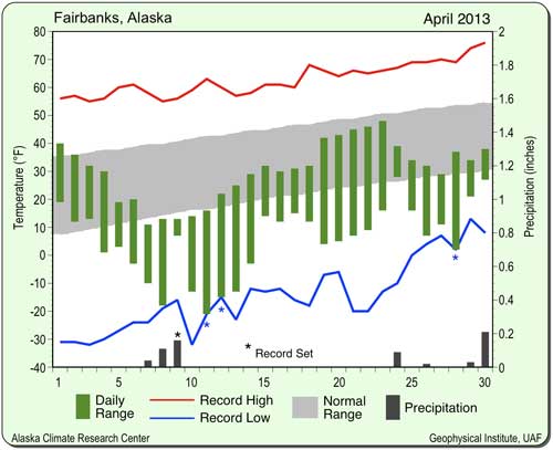
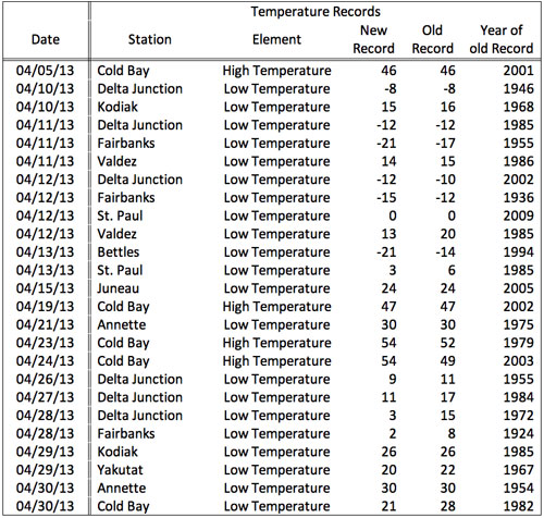
In Fairbanks, the average April temperature was a chilly 18 degrees Fahrenheit, an extraordinary 14.5 degrees below the long-term mean. It was also the third coldest April on record for the last 100 years. The highest temperature was 48 degrees on the 23rd. The month’s lowest temperature was a chilly minus 21 degrees on April 11. A new daily record low was set on that date (minus 21 degrees), breaking the old record set in 1955. Another record low was set the following day with minus 15 degrees, which broke the 1936 record. On April 28, the temperature bottomed out at 2 degrees Fahrenheit, shattering the record from 1924 (8 degrees). With the exception of the first three days of the month, temperatures stayed significantly below normal.
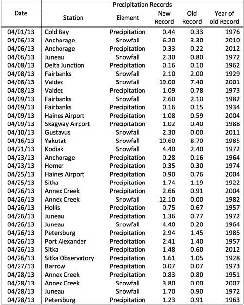
Precipitation in Fairbanks was above normal in April with a total of 0.66 inches, more than twice the normal of 0.31 inches. A total of 0.16 inches or water equivalent precipitation on April 9 was a new record for that day, just edging out the 1934 record of 0.15 inches. Snowfall totaled 9.9 inches, 241 percent higher than the expected 2.9 inches. The 8th saw 2.1 inches of snow come down, just breaking the record of 2 inches set way back in 1929. This was followed on the 9th with 2.6 inches more of snow topping the 2.1 inches from 1982. All this snow added up the eighth snowiest April on record. Mean snow depth (21 inches) was 75 percent above normal for April. The snow depth of 18 inches at the end of the month was well above the normal of just one inch. The mean wind speed was 6.1 mph, with a maximum gust of 40 mph on the 24th. It blew from a westerly direction. In Delta Junction, the mean temperature for April was 17.1 degrees Fahrenheit, which was a phenomenal 15.1 degrees below the long-term normal of 32.2 degrees. The month’s highest temperature was a pleasant 48 degrees observed on the 23rd. The month’s lowest temperature was minus 13 degrees on the 13th. This also set a new daily low, breaking the 2002 value of minus 10 degrees Fahrenheit. Five more record low events were set in the month. On the 10th, the low of minus 8 degrees tied the 1946 record. On April 11, minus 12 degrees tied the record from 1985. Jumping to the 26th, 9 degrees broke the record from 1955 (11 degrees). The 27th saw 11 degrees Fahrenheit, eclipsing the record from 1984 (17 degrees). Finally, the 28th saw 3 degrees that shattered the 1972 record. Daily temperatures stayed well below normal for the month with the exception of the first three days. Precipitation in Delta Junction was above average, with a reported total of 0.36 inches, above of the expected amount of 0.23 inches. On April 8 there was 0.16 inches of precipitation equivalent, which was a new daily record that broke the 0.10 inches from 1962.
Precipitation was high at 1.03 inches, 119 percent above the normal of 0.47 inches. The precipitation equivalent of 0.33 inches on the 6th topped the record just set in 2012 (0.22 inches). On April 23, 0.28 inches came down and broke the 1964 record (0.16 inches). Snowfall totaled 16 inches, 12 inches above the expected amount. On April 6, 6.2 inches fell topping the 2010 record of 3.3 inches. Trace amounts or more of snow fell on eight days during the month. The average wind speed was 6.3 mph, with a maximum wind speed of 39 mph reported April 25. It blew from a northwesterly direction. For Barrow, April had a below normal mean temperature with a value of 0.6 degrees Fahrenheit, a deviation of 1.2 degrees below the normal of 1.8 degrees. Temperatures were varied throughout the month. The lowest temperature, minus 26 degrees, occurred on the 7th. The month’s highest temperature was reported on the 23rd. It was 28 degrees Fahrenheit. Despite the general warming trend for Barrow, April, like February, marked another month where the mean monthly temperature had a negative deviation. Precipitation in Barrow (0.19 inches) was 0.03 inches above the normal value of 0.16 inches. A total of 0.07 inches of water equivalent fell April 27 and tied the record from 1973. Snowfall was also above normal at 5.2 inches, 2 inches above normal. Trace amounts or more of snow fell on 19 days during the month. The average wind speed was 11 mph. The month’s maximum gust was 45 mph and occurred on the 22n. It blew from a southwesterly direction. In King Salmon, the average temperature for April was 28.4 degrees Fahrenheit, 5.3 degrees below the long-term mean of 33.7 degrees. Temperatures started the month above normal, then cooled on the 5th and stayed cold until mid-month. After that time, the temperatures varied. The month’s minimum temperature, 1 degree, was reported on the 9th and 11th. The month’s maximum temperature, 52 degrees, occurred on the 24th. King Salmon experienced a dry April, with a precipitation total of 0.20 inches or just 21 percent above the long-term mean of 0.97 inches. Total monthly snowfall was 0.8 inches, 3.1 inches below normal. The average wind speed was 9.7 mph. The month’s highest gust of 43 mph occurred April 25. It blew from a northerly direction. Kodiak was colder than normal in April. The month’s mean temperature was 33.8 degrees Fahrenheit, 3.8 degrees below the expected mean of 37.6 degrees. Temperatures were varied throughout the month, with the exception of some very cold days during the second week. The low of 15 degrees on April 10 was a new daily record. It broke the 1968 value of 16 degrees Fahrenheit. April 29 tied the record low of 26 degrees set both in 1985 and 1951. The maximum temperature for the month, 52 degrees, was observed April 24. The minimum temperature was 13 degrees reported on the 11th. Kodiak's precipitation was very light with a total of 2.57 inches, just 44 percent of the expected amount of 5.81 inches. Snowfall was also light at 4.6 inches, only 58 percent of normal. The snowfall total of 4.4 inches on April 21 set a new daily record. It broke the previous value of 2.4 inches set in 1972. The average wind speed was 10.1 mph. The month’s highest wind gust occurred April 9. It was 47 mph and blew from a southwesterly direction. Nome had a mean temperature for April of 16.3 degrees Fahrenheit. This was a significant 4.2 degrees below the normal value of 20.5 degrees. Temperatures varied considerably, with a cold spell during the second week of the month. The maximum temperature was 38 degrees April 24. The minimum temperature for the month was a chilly minus 8 degrees Fahrenheit that was observed on the 11th and 12th. Nome had below normal precipitation in April, with a total of 0.30 inches. This was 39 percent of the normal amount of 0.76 inches. Snowfall was also light, with a total of 4.5 inches, 60 percent of the normal of 7.5 inches. The average monthly wind speed was 5.5 mph. The month’s maximum wind speed was 38 mph. It occurred on the 6th and blew from a northerly direction.
Chart courtesy Alaska Climate Research Center
Chart courtesy Alaska Climate Research Center
Chart courtesy Alaska Climate Research Center
Edited by Mary Kauffman, SitNews
This information consists of preliminary climatological data compiled by the Alaska Climate Research Center, Geophysical Institute, University of Alaska Fairbanks.
E-mail your news &
photos to editor@sitnews.us
|
||