 Forest Service Updates Hubbard Glacier Status May 05, 2004
"Hubbard has been advancing for the past few months and is currently about 640 feet from closing off Gilbert Point," said Yakutat District Ranger Tricia O'Connor. "It has advanced about 1000 feet in the past two to three months." 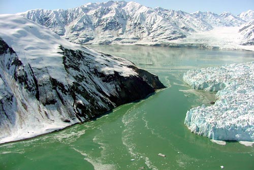
"Although the situation is currently not life threatening we are very concerned for the residents and economic health of Yakutat," said O'Connor. "If the lake level rises to 135 feet, the fiord would drain southward into the Situk River drainage, affecting this important fishery and flooding national forest and private land. The economy of Yakutat could be affected because the Situk River is the main sport, commercial and subsistence fishery in this community." As the lead land management agency, the Forest Service has invested a substantial amount of money and effort in studying and monitoring Hubbard Glacier for nearly 20 years and has re-intensified its efforts since the 2002 closure. The Forest Service has been working hand in hand with the Glacier Institute-University Alaska Fairbanks, U.S. Geological Survey, the National Park Service, to better understand the 1986 and 2002 closures. The work includes bathymetry data collection in the Gilbert Point area and continued monitoring and study of the activity of the glacier. The Forest Service funded and developed more accurate topographic models of the south end of Russell Fiord and the potential floodplain in the Situk watershed using advanced laser technology, called LIDAR. "LIDAR technology offers the most accurate, expedient, and cost-effective way to capture wide area elevation information," said Bob Gubernick, engineering geologist and lead fish passage engineer for the Tongass National Forest. Other work the Forest Service has accomplished in partnership with many other federal and state agencies includes calculating water inflow and modeling potential outflow rates in Russell Fiord and Lake; using ground penetrating radar to assess the stability of the moraine at the potential spill-over notch; predicting and modeling the floodplain of the "new" Situk River; installing a stream gauge in the Old Situk River, to substantiate the assumed lack of a groundwater connection to Russell Lake, gather habitat data, and much more. "The Forest Service, along with numerous other agencies, is committed to try our best to understand all of the potential effects of this event in order to ensure public safety and health and to work with the community to prepare for this event," said O'Connor. "There is a tremendous amount of money and effort involved in trying to get a grasp on this incredible force of nature so we can better educate and inform the public about its behavior. And, of course, while we are doing our best to understand what will happen, we can't model or predict everything with 100 percent certainty." The U. S. Army Corp of Engineers also is working closely with the Forest Service and other agencies to conduct a reconnaissance report to investigate the feasibility of mitigation to reduce the impacts of the overflow event from affecting the Situk River. Glaciologists from U.S. Geological Survey and University of Alaska predict that eventually, a stable ice dam will form and could block the entrance into Russell Fiord for many years. However, according to glaciologists, it also is possible that Hubbard Glacier may continue this cycle of blockage and dam breakage before it forms a stable dam. As the glacier continues its advance, the Forest Service will provide regular updates to keep the public informed. The Tongass National Forest has established a link to information about Hubbard Glacier on its website at www.fs.fed.us/r10/tongass/ Hubbard Glacier, the largest calving tidewater glacier in North America, originates in Canada, flows through Wrangell-St. Elias National Park and ends in the northwest corner of the Yakutat Ranger District.
Hubbard Glacier:
|