 Discovering The Geology of
Ketchikan
Discovering The Geology of
Ketchikan
By Marie L. Monyak
April 06, 2006
Thursday
Ketchikan, Alaska - Road builders blast them, children throw
them, gardeners curse at them and collectors pick them up. What
are they? Why rocks of course! And as most local know, Revillagigedo
Island is one large mass protruding from the ocean which earned
it the knick-name "The Rock."
This past Friday evening the Southeast Alaska Discovery Center
sponsored their weekly Friday Night Insight Program to a large
crowd gathered in their comfortable theatre. The guest speaker
was Julie Rowe who gave a highly informative presentation on
"History in Rocks - The Geology of Ketchikan."
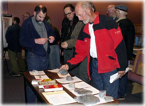 Audience members looking
over rock samples, reference materials
Audience members looking
over rock samples, reference materials
and the USGS map in the background.
Photo by Marie L. Monyak
Rowe works as a U. S. Forest Service Recreation Specialist but
spoke as a private citizen using her past experience as an Interpretive
Park Ranger and her education in Evolutionary Biology and Geology
to educate those present on how and why Revillagigedo Island
came to be.
The defining word in that last statement was Evolutionary.
Rowe started her presentation at the very beginning, a time
in Earth's history when Alaska did not exist. Those in attendance
that possessed a basic understanding of geology found it easy
to follow along with Rowe as she progressed from the Cenozoic
Age through to present day.
With the assistance of a Power Point presentation and a geologic
map and reports issued by the United States Geological Survey,
Rowe was able to demonstrate the process of folding and faulting
of the earth's crust known as tectonics.
The audience viewed slides and diagrams that demonstrated how
large land masses called "terranes" would collide with,
and in essence, become welded onto the North American continent.
Different terranes would collide with our continent at different
times in geologic history.
The enormous heat and pressure created by these collisions would
melt the rock and change their components. Over a period of
millions of years, one terrane after another would crash into
the continent changing the composition of the rock involved and
causing the land mass to rise up to the surface.
The process known as "subduction"
occurs when two plates of earth's crust collide and the extreme
energy involved forces one plate to dive underneath. Picture
a large truck and a compact car involved in a head on collision
whereby the truck would literally climb over the compact car.
Due to this subduction, volcanic activity began in the area
of Southeast Alaska.
Rowe went on to explain the process of "metamorphism"
which is how rocks changed or were altered by the extreme heat
and pressure mentioned earlier. Much like a baker gathering
the ingredients to make bread, each ingredient has its own characteristics
but once blended and baked, the heat involved has caused the
ingredients to change or metamorphosis in an entirely new substance.
According to Rowe there are three terranes in the Ketchikan and
Misty Fiords area. These terranes collided during the Mesozoic
Age, between 66 and 245 million years ago. Separating each of
these terranes are, (thankfully) inactive faults.
The Stikine Terrane is in the northeast area of Misty Fiords
and extends to the Hyder area. The Tracy Arm Terrane covers
the length of Southeast Alaska, most of the Portland Peninsula
and Rudyerd Bay. Taku Terrane is the largest by far, encompassing
all of Revillagigedo Island, the western edge of the Portland
Peninsula and much of the Cleveland Peninsula.
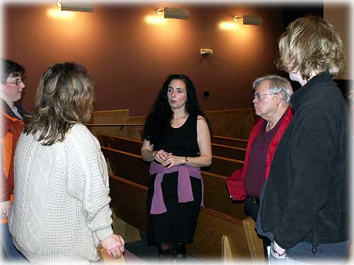 Guest speaker was Julie
Rowe (middle) talks with audience members.
Guest speaker was Julie
Rowe (middle) talks with audience members.
Photo by Marie L. Monyak
Once the earth moved into the Tertiary period, based on Rowe's
research, the terranes had finished colliding in our area but
volcanic activity continued. The well-known New Eddystone Rock
in the Behm Canal is a perfect example of what is known as a
volcanic plug.
Rowe described a plug as the "throat" or "neck"
of a volcano. Once the neck is filled with magma and the volcano
becomes dormant, natural erosion from weather occurs and eventually
all that remains is the erosion resistant plug.
Since Rowe had transported the audience through the geologic
history of the area and explained how the terranes were altered
by metamorphism she proceeded to discuss the results of this
metamorphosis that we see around us every day.
Most residents would describe our local rock as granite and shale
and they would be only partially correct. The dark grey, slightly
shiny rock most common on our island is called phyllite. A
wonderful display can be seen on North Tongass Highway along
the stretch from Wolf Point to WalMart.
Phyllite began its life on the ocean floor as nothing more than
sediment, it hardened over time and became shale. During tectonic
collisions the shale is heated under tremendous pressure where
it becomes slate. When slate is compressed even more it become
phyllite. The flaky texture makes phyllite easy to recognize.
Depending on how light reflects on the rock it tends to shine
due to the tiny mica crystals that are beginning to form.
Another common rock in this area is basalt which is a certain
type of lava that is dark brown and contains many holes that
were formed by gas bubbles. Relatively new in geological terms,
only 600,000 years old, New Eddystone Rock is basalt.
A prominent light and dark banded rock common to our area is
known as gneiss which may have begun as a sedimentary rock (formed
by fragments deposited by wind, water or ice) or as igneous rock
(formed by the solidification of magma or lava).
What many refer to on our island as granite is actually granodiorite.
This is a plutonic crust that has re-melted and re-cooled as
it rose to the surface during a collision of terranes. On North
Tongass Highway, across from the scenic outlook is an excellent
example of granodiorite recognized by its grey to black specks
on its white background.
On a stretch of South Tongass Highway, just past Herring Cove
and slightly before the old cannery one can see rocks that are
a part of the gabbro pluton. Gabbro has the same mineral composition
as basalt but unlike basalt, it was formed by magma that cooled
underground.
In conclusion, Rowe stated that although she was not thoroughly
pleased with the book Roadside Geology of Alaska, she
tentatively recommended it for its basic descriptions of the
rocks in each terrane adding that there simply aren't any other
books on the Geology of Alaska.
As the presentation ended the audience moved to the front of
the theatre to peruse the rock samples and to study the USGS
quadrangle of Ketchikan and the surrounding area that Rowe provided.
This week's Friday Night Insight program to be held on April
7th at 7:00 P.M. will be "Gardening in Ketchikan" presented
by local horticulturist Jeannie Blackmore. Jeannie will share
her knowledge of gardening using her personal homegrown experiences
as examples.
On the Web:
United States Geological Survey
http://www.usgs.gov/
Marie L. Monyak is
a freelance writer living in Ketchikan, Alaska.
A freelance writer is an uncommitted independent writer
who produces and sells articles to a publisher such as SitNews.
Contact Marie at mlmx1[at]hotmail.com
Send your story ideas
to editor@sitnews us
Publish A Letter on SitNews Read Letters/Opinions
Contact the Editor
SitNews
Stories In The News
Ketchikan, Alaska
|