
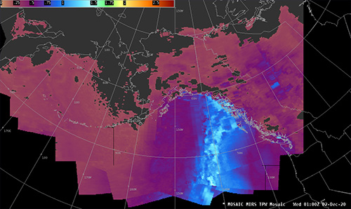
Satellite images reveal the atmospheric river that caused a fatal mudslide in Haines, Alaska, on Dec. 1-2, 2020. The image shows a column of total precipitable water headed to Alaska from south of Hawaii. |
Now, Dierking helps his former colleagues know when one of these drenching events is about to impact Alaska, with the help of satellites orbiting 500 miles overhead. He works for the Geographic Information Network of Alaska, part of the University of Alaska Fairbanks Geophysical Institute. His tools are instruments aboard the satellites that measure how much moisture is in a certain part of the atmosphere, even when it is cloudy.
Alaska has giant swaths of unpeopled country with no twirling weather radars, or none that can see beyond where mountains are blocking them.
“Satellite data is really our only tool for seeing where heavy rain is impacting a (remote) area,” Dierking said.
By looking at information right after a polar-orbiting satellite dumps its invisible information into two satellite dishes near Fairbanks, Dierking can make sense out what a satellite has seen. The satellites use a passive microwave detector to measure energy emitted by rain.
“It’s not a simple process, but there’s a signal you can squeeze out to get the intensity of rainfall,” Dierking said.
Using that information, the scientists can predict an atmospheric river event, such as the one that resulted in more than 10 inches of rain falling on Haines and other Southeast towns in early December 2020. Two people died from mudslides in Haines. Heavy rain falling on fresh snowfall also caused other debris flows and flooding.
“That event brought moisture up from south of Hawaii,” Dierking said.
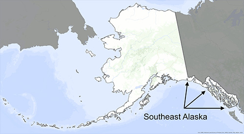
Southeast Alaska is the state's mountainous "panhandle" along the Pacific Ocean coast. |
One thin cross-section slice of an atmospheric river can carry almost three times more water, in vapor form, than the flow at the Amazon River’s mouth, said Marty Ralph of the Scripps Institution of Oceanography in California.
Ralph studied atmospheric rivers as both a good thing — in busting droughts in the state - and a bad thing — when one lingers and supersaturates the landscape at the wrong time.
In Southeast Alaska, Dierking often texts Aaron Jacobs, a meteorologist at the National Weather Service in Juneau, to compare notes when instruments suggest the area is about to experience an atmospheric river.
Jacobs, who has also studied atmospheric rivers for years, said warmer air temperatures in recent years have probably made atmospheric rivers more intense when they hit Alaska and mountains wring out moisture.
“In a warming environment, the atmosphere can hold more water,” Jacobs said. “That means more available water vapor to precipitate out.”
Atmospheric rivers are not all the same, Jacobs said.
“A strong but quick moving atmospheric river — less than 24 hours in duration - may not be as impactful (as) a moderate-but-long-duration 48-hour event.”
The time of year atmospheric rivers happen also matters, such as following a fresh snowfall that melts easily.
Jacobs said that while more atmospheric rivers may not be striking Alaska now than in the past, they are becoming more intense.
“We are seeing more extreme-precipitation records being broken in the last 10 years,” he said. “In Juneau, for example, in the last two years we have seen the wettest day and the third-wettest ever, going back to the mid 1930s. Both of these events were associated with atmospheric rivers.”
Since the late 1970s, the University of Alaska Fairbanks' Geophysical Institute has provided this column free in cooperation with the UAF research community. Ned Rozell [ned.rozell@alaska.edu] is a science writer for the Geophysical Institute. |
Representations of fact and opinions in comments posted are solely those of the individual posters and do not represent the opinions of Sitnews.
Send a letter to the editor@sitnews.us
SitNews ©2022
Stories In The News
Ketchikan, Alaska
Articles & photographs that appear in SitNews are considered protected by copyright and may not be reprinted without written permission from and payment of any required fees to the proper freelance writers and subscription services.
E-mail your news & photos to editor@sitnews.us
Photographers choosing to submit photographs for publication to SitNews are in doing so granting their permission for publication and for archiving. SitNews does not sell photographs. All requests for purchasing a photograph will be emailed to the photographer.