Ketchikan Plans Alaska Shield 2014 ExerciseBy MARY KAUFFMAN March 22, 2014
The emergency tsunami warning TEST will be broadcast on NOAA Weather Radio All Hazards, local television and radio stations, and residents in some communities may hear warning sirens. To avoid any confusion with an actual alert the TEST will be canceled if there is excessive seismic activity 24 hours prior to the test.
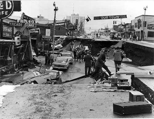
Alaska Earthquake March 27, 1964 - downtown Anchorage, Alaska.
Here's the TEST scenario of what happens in Ketchikan: On Thursday, after weeks of preparation and community outreach, Ketchikan dispatch and the public will be notified of the live code TEST from the National Tsunami Warning Center (NTWC) by the National Weather Service’s (NWS) direct phone and the Emergency Alerting System (EAS). This TEST provides the community an opportunity to practice a DROP! COVER! HOLD ON! Exercise area wide. As part of Ketchikan's TEST scenario: Friday, Ketchikan experiences a large/intense earthquake throughout the island. The earthquake causes Ketchikan Public Utilities (KPU) concern about the Ketchikan Lakes dam which then triggers the KPU Ketchikan Lakes Emergency Action Plan, at a Condition C; “Non Failure Emergency”. The Ketchikan Borough Fire Chiefs and Ketchikan City Emergency Manager and Police Chief are then contacted by dispatch. In the TEST, concurrently, the earthquake scenario causes a fuel tank spill at Petro Marine Services’ upper tank farm which escalates to a fire. The Alaska Department of Transportation and Public Facilities (ADOT) work crews realize the Ward Creek Bridge experienced substantial structural damaged during the earthquake. The ADOT maintenance crew contact Ketchikan dispatch regarding the damage, consequentially the bridge is immediately shut down, closing all vehicle access from North Tongass area to the City of Ketchikan and, more importantly the hospital until the damage can be assessed by ADOT engineers. Damage to several residential homes is also reported to dispatch by the public. As part of the Alaska Sheild exercise, the Ketchikan area Incident Management Team (IMT) will assemble a Joint Information Center (JIC) to address public concern and disseminate the information from the local, state, and federal authorities to the public, quelling the public panic and rumors. The incidents are handled in less than one operational period and then the Ketchikan area IMT and JIC are demobilized. Earthquakes are not rare events in Southeast Alaska. In October 2012, a 7.7 magnitude quake that shook the Queen Charlotte Islands grabbed Ketchikan's attention. This was followed in January 2013 by a magnitude 7.5 earthquake that ripped the sea floor about 80 miles west of Craig around midnight on Jan. 4th. That earthquake released most of its energy in the first 20 seconds, but it took 50 seconds for 85 miles of the Queen Charlotte Fault to rupture. The fault slices Earth in a north-south swath just west of Southeast Alaska. The great Alaska earthquake of 1964, by comparison, tore the sea floor for six full minutes. On June 28, 2004 at approximately 1:49:36 am Alaska Time, a 7.0 magnitude earthquake was also reported off the coast of Southeast Alaska 65 miles WSW of Craig, Alaska. “The Great Alaska Earthquake of 1964” occurred in Prince William Sound. When it was finally over, Anchorage was in ruins, a victim of a massive magnitude 9.2 earthquake, the second largest earthquake ever recorded in world history. The 1964 Alaska tsunami generate by the quake was the second largest ever recorded, following the May 1960 Chile earthquake with a magnitude 9.5. Much of the damage and most of the lives lost during the 1964 quake were due to the effects of water waves. These were mainly of two kinds: the tsunami of open-ocean sea wave, generated by large-scale motion of the sea floor; and the local wave, generated by underwater landslides in bays of fiords. Of the deaths attributable to the effects of the ocean, about one-third were due to the open-ocean tsunami: 4 at Newport Beach, Oregon; 12 at Crescent City, California; and about 21 in Alaska. Local waves claimed at least 82 lives. Maximum height reported for these waves were 229 feet in Valdez Arm. The 1964 earthquake effects were heavy in many other Alaska towns, including Chitina, Glennallen, Homer, Hope, Kasilof, Kenai, Kodiak, Moose Pass, Portage, Seldovia, Seward, Sterling, Valdez, Wasilla, and Whittier. During the 2014 Tsunami Preparedness Week, many television systems are programmed to scroll a standard emergency alert text message and in some cases, the message may not contain the word “TEST.” An audio message will say that the message is only a test, but if the volume is turned down or otherwise unheard, viewers may not realize the message is a test. In addition, siren audio may not contain the word “TEST.” The test is part of Tsunami Preparedness Week, proclaimed by Gov. Sean Parnell as March 23 to 29, and is a cooperative effort of NOAA’s National Weather Service, Alaska’s Division of Homeland Security and Emergency Management, Alaska Broadcasters Association, and local emergency management officials. Emergency managers urge coastal residents to review information on what to do in the event of a tsunami. NOAA’s National Tsunami Warning Center web site offers complete information, including the current status of tsunami watches, warnings and advisories. A list of frequently asked tsunami questions and answers as well as tsunami safety rules can be found on the Center’s site under “Education.” Officials are asking coastal Alaskans to provide feedback online at ready.alaska.gov.
E-mail your news &
photos to editor@sitnews.us
|
||