 February: Colder than normal
in the Alaska Panhandle
February: Colder than normal
in the Alaska Panhandle
Precipitation below average
for parts of Southeast
March 10, 2009
Tuesday
Temperature conditions were colder than normal in the Panhandle,
the Southcentral, and the northwest coast, while the Interior
and southwestern Alaska experienced warmer than normal temperatures.
For many locations the month began on the cool side, and was
followed by a moderation in temperatures. This temperature was
aided by the perceptible increase in daylight throughout February.
Precipitation conditions were below average for parts of Southeast
and Southcentral , though more than twice the normal amount of
precipitation fell in the western half of the state.
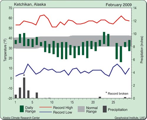
Ketchikan had a mean monthly
temperature of 31.9 degrees Fahrenheit, which is 4.4 degrees
cooler than normal for February. Average high and low temperatures
were 37 degrees and 26 degrees, respectively. The monthly high
and low temperatures were 46 degrees Feb. 22, and 16 degrees
Feb. 26. Heating degree-days totaled 884 units for the month.
There was a record daily precipitation event Feb. 3, with 3.44
inches of rain. For the month on the whole, precipitation totaled
8.67 inches, nearly 3 inches below normal for February. Winds
averaged about 6 mph at the airport, and were strongest during
the first half of the month.
Temperatures averaged below normal in Juneau this February, with
a mean temperature of 27.2 degrees Fahrenheit. On average, high
and low temperatures were also below normal at 33 degrees and
21 degrees, respectively. The highest and lowest temperatures
were 38 degrees Feb. 7, and 7 degrees Feb. 13. Heating degree-days
were about 50 units above average at 1,057 for the month. Snowfall
totaled one foot more than normal at 30.4 inches. This amount
included some impressive daily snowfall totals of 7.2 inches
Feb. 8, and 8.8 inches Feb. 3. There were 5 inches of snow on
the ground by month's end. Liquid equivalent precipitation was
3.89 inches, 0.13 inches below normal for February. Winds averaged
nearly 6 mph and the highest reported gust was 46 mph on Feb.
7.
Overall, it was a warmer and wetter than normal February for
Fairbanks this year. Abundant snowfall at the end of the month
was the big weather story as 6.5 inches fell at the Fairbanks
International Airport on Feb. 28, a record total for the date.
The monthly snowfall total was 14.1 inches, which helps to partially
make up for the seasonal snow deficit. Season-to-date, the snowfall
is 56 inches, which is four inches below normal for this time
in the season. Water equivalent precipitation totaled 0.59 inches,
almost one quarter more than what is considered normal for February.
There were 22 inches of snow on the ground at the start of March.
Temperatures varied widely from minus 43 degrees Fahrenheit Feb.
3 to 35 degrees Fahrenheit Feb. 19. The average temperature for
the month was 2.3 degrees above normal at minus 1.5 degrees.
Heating degree-days were almost 70 units less than normal, and
totaled 1,858 for the month. Winds at the airport were characteristically
light for winter, averaging 2 mph. However, on Feb. 26, a high
gust of 33 mph was reported.
Big Delta had a mean monthly temperature of 7.3 degrees Fahrenheit
in February. Observations were missing on six days, five of which
occurred the last week of the month. The high temperature of
50 degrees on Feb. 19 broke the previous record for that date
and the low for the month was minus 33 degrees on Feb. 1. Average
high and low temperatures for the month were 17 degrees and minus
2 degrees, respectively. Precipitation in liquid water equivalence
totaled just two-tenths of an inch, though three days were missing.
No snow observations were available. Winds averaged 11 mph, with
a peak wind of 45 mph out of the southeast on Feb. 27.
Anchorage had a slightly cooler than normal February, with a
mean monthly temperature of 17.7 degrees Fahrenheit, which is
one degree below normal. High and low temperatures averaged 24
degrees and 12 degrees, respectively. The monthly high and low
temperatures were 38 degrees Feb. 19, and minus 11 degrees Feb.
3. Heating degree- days were quite close to normal at 1,316 units,
20 units above average. Water equivalent precipitation was about
one-third of an inch less than normal at 0.45 inches. Snowfall,
however, was 2.6 inches more than normal at 13.6 inches. This
snowfall brought the season-to-date total up to 77 inches, which
is almost two feet more than normal. Snow on the ground totaled
16 inches by the start of March. Winds averaged 5 mph for the
month.
Snowfall was abundant in Nome during February, with 35.1 inches
falling during the month. This was more than two feet above average.
A new daily snowfall total was set with 8.2 inches Feb. 18. Since
July 1, Nome has received almost 75 inches of snow, well above
the average 51 inches for this point in the season. A whopping
55 inches of snow were on the ground at the start of March. The
average snow depth for this time of year is 16 inches. Liquid
equivalent precipitation was about one inch more than normal,
with 1.79 inches for the month. Along with the abundant snowfall,
there were cooler than normal temperatures. The average temperature
of 1.6 degrees Fahrenheit is 4.1 degrees below normal for February.
On average, high temperatures were near normal at 13 degrees,
though nighttime lows were well below normal at minus 10 degrees.
Due to the cooler weather, heating degree-days totaled 1,773
units, 110 units more than normal. Winds averaged about 11 mph,
though a storm system brought high winds at the end of the month,
with gusts of 45 mph reported Feb. 27.
The February snowfall total in Barrow was 11.4 inches, about
five times the normal snowfall total of 1.9 inches. This represents
the snowiest February on record. On Feb. 19, a 2.4-inch snowfall
set a new record for the date. Snow on the ground averaged 19
inches for the month, and 20 inches were on the ground to start
off March. As one would expect, the liquid equivalent precipitation
was also well above normal at 0.44 inches. Normal precipitation
for February is 0.12 inches. Temperatures, however, averaged
out to be the climatological normal for the month at minus 15.9
degrees Fahrenheit. While this is a rarity, especially in winter,
it is merely a statistical representation since the actual temperatures
were well below normal for the first half of February and then
soared to record highs during the latter half of the month. The
thermometer reached a high of 26 degrees Feb. 23, setting a new
record for the date. A low of 47 degrees below zero occurred
on Feb. 12. Heating degree-days were quite close to normal at
2,260. However, since July 1, 2008, the heating degree-day cumulative
total of 12,337 is about 850 units below normal. This indicates
the relative warmth in Barrow for this winter season on the whole.
Winds averaged about14 mph during February, with the highest
gust of 48 mph observed Feb. 28. The second half of the month
had markedly higher winds than the first half.
There were some wide temperature
swings in King Salmon during the first part of February. However,
the second half of the month brought mostly above normal temperatures
and more moderate conditions. The low for the month was 34 degrees
below zero Feb. 2, while the high for the month was 41 degrees
Fahrenheit Feb. 15. Average high and low temperatures were 27
degrees and 5 degrees, respectively. The average monthly temperature
was 15.9 degrees, just three-tenths of a degree above normal.
Heating degree-days were also not far from normal with 1,366
units for the month. Precipitation (liquid water equivalence)
was almost one inch above average at 1.67 inches. Snowfall was
also above normal with 8.8 inches, coming primarily in the first
half of the month. Only one inch of snow was on the ground by
the start of March. Winds averaged nearly 9 mph at the airport
and on Feb. 25, a gust of 63 mph was reported.
This information consists of preliminary climatological data
compiled by the Alaska Climate Research Center, Geophysical Institute,
University of Alaska Fairbanks.
Source of News:
Alaska weather and climatology
http://akclimate.org
E-mail your news &
photos to editor@sitnews.us
Publish A Letter in SitNews Read Letters/Opinions
Contact the Editor
SitNews
©2009
Stories In The News
Ketchikan, Alaska
|