 February in Alaska, a cold
start
February in Alaska, a cold
start
Ketchikan received 18.59 inches
water equivalent
March 10, 2008
Monday
Temperatures throughout Alaska this February varied much like
they did in January with a cold start and a warm finish. The
first two weeks of the month brought well below normal, and even
record low temperatures, to the state according to preliminary
climatological data that compiled by Martha Shulski at the Alaska
Climate Research Center, Geophysical Institute, University of
Alaska Fairbanks.
Around mid-month the weather
conditions around the state rebounded, though February finished
cooler than normal for almost all locations statewide. Along
with the cold came a general lack of precipitation that was strongest
for the central Interior. However, some locations in the north,
southwest, and the Panhandle did finish with above normal precipitation
totals.
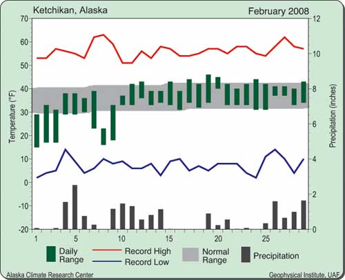
Precipitation, primarily in
the form of snowfall, was well above normal in Ketchikan in February,
with a total of 18.59 inches water equivalent. This amount was
more than 7 inches above average. Temperatures were slightly
cooler than average, with the month mean of 34.4 degrees Fahrenheit,
which is almost 2 degrees below normal. The average high and
low temperatures for Ketchikan were 39 degrees and 30 degrees,
respectively. The extreme high and low for the month were 46
degrees February 19 and 15 degrees on the 1st. Heating degree-days
were 45 units more than normal with 850 units.
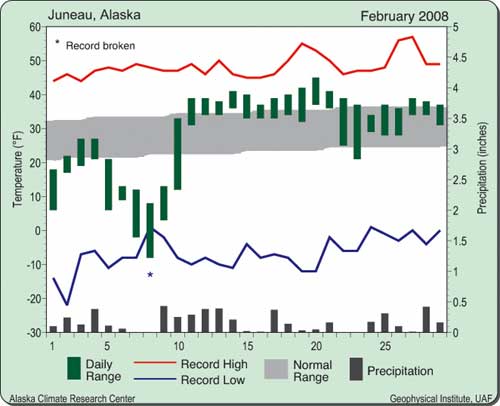
A record low temperature and more than twice the normal snowfall
total were just a couple of the weather highlights in Juneau
this February. Overall, the month was cooler than normal, with
a mean temperature of 27.9 degrees Fahrenheit, a departure of
minus 1 degree. The average high and low temperatures were 32
degrees and 24degrees, respectively. The extreme high and low
temperatures were 45 degrees on February 20 and minus 8 degrees
on the 8th. The temperature on February 8 set a new record low
for the day. Heating degree-days totaled about 1,070 units, a
bit more than normal for February. Water equivalent precipitation
was almost an inch more than normal at 4.92 inches. There were
only three dry days during the month. Snowfall was more than
twice the normal amount, with 44.2 inches. The snowfall came
mostly during the first 10 days of the month, with a high one-day
total of 7.3 inches on February 4. Due to the relative warmth
and above freezing daytime temperatures, only a trace of snow
was on the ground at the airport by month's end.
For a second straight month,
Fairbanks experienced wide temperature swings; from a daily record
high of 41 degrees Fahrenheit on February 20 to a near-record
low of minus 48 degrees Fahrenheit on the 10th. During the first
two weeks of the month there were eight consecutive days with
low temperatures at, or below, minus 40 degrees. After a rebound
during the third week to well above normal temperatures, the
last few days of the month moderated and temperatures were near
normal. The mean temperature for the month was minus 5.9 degrees,
a departure from normal of minus 2.1 degrees for February. The
average high and low were also a few degrees below normal at
7 degrees and 19 degrees below zero, respectively. Heating degree-days
were about 125 units more than normal with 2,050 units. The liquid
water equivalent precipitation totaled 0.18 inch, half the normal
amount for February. Snowfall was a few inches below normal at
5.4 inches. There were 17 inches of snow on the ground by the
start of March at the Fairbanks International Airport. On the
last day of the month, the airport reported a 38 mph wind gust
out of the northeast, attributable to a strong pressure gradient
from a deep low to the southwest and a strong high to the northeast.
Big Delta had a wide range in temperatures, and a couple of record
highs during the third week of February. The conditions made
for an overall cooler and drier than normal month. The average
temperature of 1 degree Fahrenheit was slightly cooler than the
normal 2.3 degrees for February. The highs of 44 degrees on February
20 and 41 degrees on the 21st were both records for their respective
dates and the former was the high for the month. The low of 45
degrees below zero on February 7 occurred during the 10-day cold
snap that started off the month. February began with five consecutive
days with temperatures at, or below, minus 40 degrees Fahrenheit.
The average high and low temperatures were slightly below normal
at 10 degrees and minus 8 degrees, respectively. Heating degree-days
totaled 1,759 units, 30 more than normal. Liquid water equivalent
precipitation totaled just a tenth of an inch, 25 percent of
normal for February. No snow data were available.
Anchorage had a generally cool and snowy February this year.
Snowfall totaled 17.4 inches and came mostly around mid-month.
This total is more than 6 inches above average for February,
and 12 inches of snow were on the ground at the Ted Stevens Anchorage
International Airport by the end of the month. Liquid water equivalent
precipitation totaled 0.85 inch, also above average. The mean
monthly temperature, 16.7 degrees Fahrenheit, was 2 degrees below
normal. The average high and low temperatures were 24 degrees
and 10 degrees, respectively. The highest temperature for the
month was 44 degrees, and occurred on February 19. The lowest
temperature of the month was minus 12 degrees, and was reported
February 4-5. Heating degree-days were 100 units more than normal,
with a total of 1,395 for the month.
The weather in Barrow in February was warmer and wetter than
normal. Temperatures varied from a high of 21 degrees Fahrenheit
on February 21 to a low of minus 39 degrees Fahrenheit on the
6th. The average high and low temperatures were minus 7 degrees
and minus 21 degrees, respectively. The average for the month
was minus 14 degrees, which is 2 degrees above normal for February-climatologically
the coldest month in Barrow. Heating degree-days were about average
for the month, with 2,287 units. Liquid water equivalent precipitation
totaled 0.22 inch, almost twice the normal amount. Snowfall was
about 3 inches more than normal for the month, with a total of
4.9 inches that came mid-month. A total of 14 inches were on
the ground by the start of March, a few inches more than normal
for this time of year.
Nome experienced a chilly February, with a mean monthly temperature
of minus 3.7 degrees Fahrenheit. This temperature is more than
9 degrees cooler than normal, yet far from record setting. The
average high and low temperatures were 6 degrees and 13 degrees
below zero, respectively. The extreme high and low temperatures
for the month were 33 degrees on February 19 and minus 33 degrees
February 2-3. Due to the cold, heating degree-days were 275 units
more than normal at nearly 2,000 units. Liquid water equivalent
precipitation totaled 0.37 inch, about half the normal total
for February. Measurable snowfall occurred on eight days during
the month for a total of 9.9 inches. This was about one inch
more than normal. There were 44 inches of snow on the ground
at the end of the month. This was due to high December and January
snowfall totals.
King Salmon experienced the same sort of temperature fluctuations
in February as it did in January. Temperatures were well below
normal for the first half of the month and then above normal
for the second half. Overall, the month ended 6.4 degrees Fahrenheit
cooler than normal, with an average temperature of 8.8 degrees
Fahrenheit. Accordingly, heating degree-days were more than 225
units above average, with 1,621 units. The average high and low
temperatures were 18 degrees and 0 degrees, respectively. The
extreme
high and low temperatures were 39 degrees on February 21 and
29 degrees below zero on the 5th. Liquid water equivalent precipitation
totaled 0.38 inch, about half of normal for February. Snowfall
also was below average for the month, with 3.9 inches reported.
This amount is 1.6 inches less than normal. One inch of snow
was on the ground at the end of the month.
This information consists of
preliminary climatological data that was compiled by Martha Shulski
at the Alaska Climate Research Center, Geophysical Institute,
University of Alaska Fairbanks.
Source of News & Graphics:
Alaska Climate Research Center,
Geophysical Institute, University of Alaska Fairbanks
http://climate.gi.alaska.edu.
E-mail your news &
photos to editor@sitnews.us
Publish A Letter in SitNews Read Letters/Opinions
Contact the Editor
SitNews
©2008
Stories In The News
Ketchikan, Alaska
|