Cook Inlet Basin amplifies earthquake shakingBy NED ROZELL
February 03, 2016
Many people in Anchorage got rattled during the recent 7.1 earthquake on January 24. Carl Tape did not feel the earthquake in Fairbanks, but in another way he knows it better than almost anyone. Last summer, Tape and his colleagues at the Geophysical Institute at the University of Alaska Fairbanks installed seismometers across Southcentral Alaska. One of the instruments is just 30 miles from the epicenter of the January 24 earthquake.
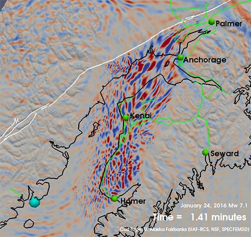
A frame from Tape’s simulations of the 7.1 earthquake that shows the shape of Cook Inlet Basin and the dramatic shaking within.
Tape and other seismologists use the ground's reaction to earthquake waves to better define what makes a sedimentary basin and what happens there in an earthquake. Not only do the people of Anchorage and the Kenai Peninsula live in a basin, but so do those living in Tokyo, Los Angeles and Seattle. "It's unfortunate because basins cause a strong amplification of ground motion," Tape said. "And damage, just like in this earthquake." The Cook Inlet Basin lies beneath the narrow ocean arm of Cook Inlet and the western half of the Kenai Peninsula extending to Anchorage and the Mat-Su valley. It consists of a deep bowl filled with mud and loose rock. The town of Nikiski, for example, rests on a four-mile-deep unstable bed of mud mixed with rock. Beneath that is a foundation of 65-million year old rock. The shape and structure of Cook Inlet Basin is no secret. Geologists have mapped its depths since before the 1950s, when drilling began for oil and gas. Tape and fellow seismologists find the petroleum maps intriguing, but they are more interested in the plate of Earth's crust that lies beneath. Scientists think it might be 30 miles thick there, but no one knows. They do know that basins are places that trap earthquake waves, slowing them down and splashing them into each other like water in a bathtub. Some places within the basin shake more and shake longer than others even though they are farther from an earthquake's epicenter. That happened during the 7.1 earthquake, with people in Anchorage reporting greater shaking than some people on the eastern Kenai Peninsula. In summer 2015, seismologist Doug Christensen led a team in installing seismic stations that are by chance in a shotgun pattern around the epicenter of the 7.1 earthquake. Christensen and others for years wanted a line of stations directly above the boundary where the Pacific Plate is grinding beneath the North American Plate. Christensen, Tape and others will not be able to read the recent dramatic data from the new network until they service them and download information next summer. They were just happy to get them installed, and they are smiling at having placed instruments right on top of the largest earthquakes ever to shake Cook Inlet Basin. "We're lucky to be able to preserve a record of basin shaking during this quake and its aftershocks," Tape said. Videos 1 and 2: Carl Tape's simulations of the seismic waves of the January 24, 2016 magnitude 7.1 earthquake. He made them using the high-performance computing cluster at the Geophysical Institute's Research Computing Systems group.
|
||