Large Landslide in Southeast Alaska
February 27, 2014
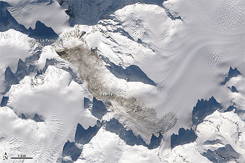
The first visual confirmation that the slide had occurred came a week ago on February 22, 2014, when helicopter pilot Drake Olson flew over and photographed landslide debris at 58.542 degrees North and 137.01 West. Landsat 8 passed over a day later, offering another view of the slide.
Landslide on the flanks of Mount La Perouse involved 68 million metric tons (75 million short tons) of material
Stark first became aware that a landslide may have occurred when a rapid detection tool that sifts through data collected by a global earthquake monitoring network picked up a signal indicative of a fairly significant event. The earthquake sensors detect seismic waves—vibrations that radiate through Earth’s crust because of sudden movements of rock, ice, magma, or debris. While both earthquakes and landslides produce both high-frequency and low-frequency waves, landslides produce more low-frequency waves on balance than earthquakes. Most earthquake detection tools are focused on high-frequency waves, but the detection tool Stark was using—the Global Centroid-Moment-Tensor (CMT) Project—also looks closely at low-frequency waves, meaning it is more likely to detect landslides than other tools. Since the Global CMT tool had detected a significant event, while other tools managed by the U.S. Geological Survey and the Alaska Earthquake Information Center had not, Stark suspected he had found a landslide. Additional analysis of the seismic data by Columbia scientists Göran Ekström and Clément Hibert confirmed Stark’s hunch, narrowing the location down to a 25 square-kilometer (10 square-mile) area in southeastern Alaska. Mount La Perouse is located in the Hoonah-Angoon region of Alaska.
E-mail your news &
photos to editor@sitnews.us
|
||