 February 16, 2006
All the cargo loaded and the crew outfitted in mustang suits to combat the cold, the Coast Guard cutter Roanoke Island cast off lines and maneuvered out of the Homer small boat harbor through the difficult "S" turn. The sun was just beginning peak the snowcapped mountains and cast rays across the water. The Roanoke Island's white hull sliced through the water as it was piloted around the end of the Homer spit and into Kachemak Bay under blue skies. The transit across Cook Inlet to Augustine Island would take three and a half hours at a distance of 60 nautical miles in good weather. 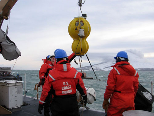 Photograph by Michael West Image courtesy of the Alaska Volcano Observatory / University of Alaska Fairbanks, Geophysical Institute
The seismometers are resting on the bottom of the ocean for six weeks until the team returns to collect them. During those six weeks they will record seismic activity from the Augustine volcano onto an on board computer. They cannot broadcast the information well through the water column so the information will be stored in the on board computer and downloaded upon their recovery. When the team returns to recover the OBS, an acoustic signal is sent from the surface ship to the OBS to release its weight. The OBS, which is naturally buoyant, will rise to the surface and be picked up by the crew. "Basically they're recording those little squiggles you think of when someone mentions seismography," said Dr. Uri ten Brink of the USGS Coastal and Marine Science Center. According to ten Brink, many of the Aleutian volcanoes are located on small islands that greatly restrict the geometry and aperture of AVO's seismographic networks. Location of seismic stations is often further restricted by strong noise generated by ocean waves, which masks the seismic signal. The noise is often amplified by the unconsolidated pyroclastic deposits (loose fragmented pieces of rock that may be minerals, crystals or glass that are ejected from a vent) that frequently make up the flanks of many Aleutian arc volcanoes. The limited extent of many of the AVO's seismographic networks often restricts the accuracy of earthquake hypocenter determination and frequently precludes the detection and tracking of volcano induced seismicity in the mid to lower earth's crust. 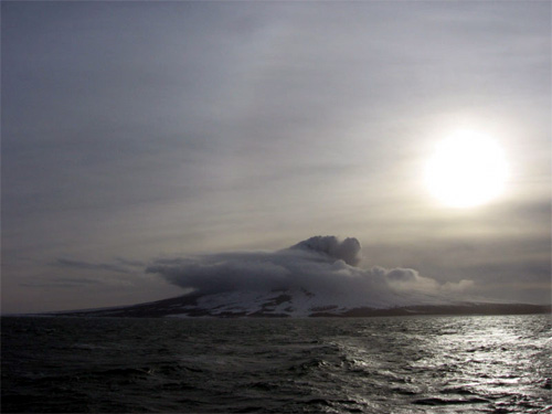 Photograph by Michael West Image courtesy of the Alaska Volcano Observatory / University of Alaska Fairbanks, Geophysical Institute
As the cutter approached Augustine Island the volcano was in full view and the crew could easily see the steam coming from the top of the mount. Ash deposits colored the peak alluding to recent eruptions. The Coast Guard has put in place a one-mile safety zone off Augustine Island for maritime traffic. "It was so clear, really beautiful," said Loreaux, operations officer on the cutter Roanoke Island. "You could see the recent activity at the top." Long flows of pyroclastic rock and debris were visible, especially along the north side of the volcano. As they neared the first OBS location the scientists filed out on deck and readied the OBS for deployment. Using the vessel's crane the OBS was raised over the water. A scientist pulled a line connected to a quick release hook and the yellow instrument vanished beneath the water. The Coast Guard deck supervisor radioed up to the Seaman Josiah Goetz, the Quartermaster of the Watch, who marked the location of the OBS using the shipboard GPS charting program on the bridge. The depth of the ocean bottom ranges between 85 - 165 feet around the island. "It was freezing cold out," said Loreaux. "Dr. ten Brink told me about launching these instruments in the Caribbean. I don't think they were expecting these temperatures and wind." As they team circled the island and deployed the additional seismometers the weather moved in, it became colder and the waves grew. 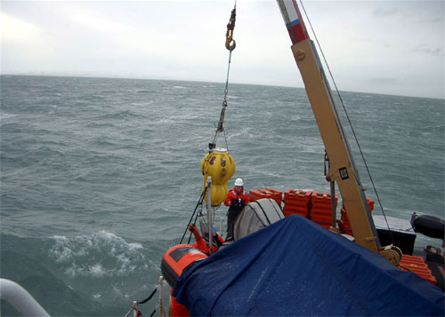
It took about four and a half hours to deploy and mark the location of all five instruments. The crew finished up around 5 p.m. and began the trip back to Homer. They were in for quite a ride. The 110-foot patrol boat bucked in the 12 - 15 foot waves. The weather prolonged the trip, four and a half hours, getting them back to shore at about 9:30 p.m. "They got an interesting ride back on a Coast Guard cutter," said Loreaux. "I was on watch on the bridge for the ride back. Trying to hold onto your seat, plot a course and keep the chart on the table through waves like that is difficult." The expedition was successful. All five instruments were deployed and there were no injuries. In six weeks the scientists will return to recover each $35,000 OBS from the ocean floor. The scientists hope to use a Coast Guard buoy tender as the recovery platform. The buoy tenders are designed to be able to keep station even in rough seas, better allowing them to recover the OBS from the bottom. The USGS has an agreement with the national OBS facility at the Woods Hole Oceanographic Institution to build and maintain 16 OBS within the facility. Five of these OBS and a modest amount of funding are available for USGS and non-USGS investigators to be rapidly deployed in response to an earthquake or volcanic activity in coastal areas. The operation off Augustine Island is the first rapid response to natural disasters in U.S. territorial waters. The Alaska Volcano Observatory (AVO), a joint program of the USGS, the AVO Geophysical Institute of the University of Alaska, and the Alaska Division of Geological and Geophysical Surveys are presently involved in monitoring Aleutian arc volcanoes and providing warnings to local communities and affected industries.
Source of News & Photos:
Publish A Letter on SitNews Read Letters/Opinions
|