February 12, 2005
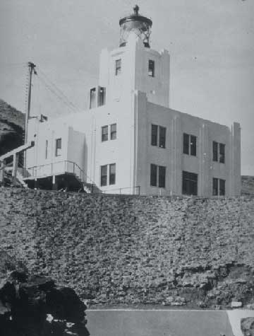
But some 60 years ago, one of the 20th Century's worst tsunamis swept from Alaska through the Pacific, killing more than 150 people. Scientists today still can't agree on just what caused it. Was it an earthquake, an undersea landslide, or both? The answer may change how scientists study tsunamis and how people prepare for them. University of Hawaii researcher Gerard Fryer says he knows exactly how the 1946 tsunami occurred. He's absolutely convinced that an earthquake triggered a gargantuan undersea landslide in Alaska's Aleutian Islands. Like a boulder dropped into a bathtub, Fryer says the landslide sent a tsunami racing at jetliner speeds across the Pacific Ocean. The waves did the most damage in Hawaii, where they killed 159 people. Another five people were killed on Alaska's Unimak Island when a reinforced concrete lighthouse at a place called Scotch Cap was leveled. Last summer, Fryer joined scientists from Scripps Institution of Oceanography on an ocean expedition to an area about 100 miles south of Unimak Island. There, Fryer says, a landslide some 20 miles wide rumbled down the continental slope to the bottom of the Aleutian Trench. Fryer and his colleagues used a remotely operated submersible and sophisticated seafloor mapping equipment to produce detailed images of the seafloor. In those images, Fryer expected to see evidence of a colossal landslide. Fryer said, "I knew for certain that there was a landslide. I knew exactly where it was. I would have bet everything on it. And then I go out there and it's not there. I was absolutely stunned." Researchers did see colorful corals and an unusual methane seep teaming with marine life. But the seafloor looked as if it had been undisturbed for millennia. Instead, a long-simmering scientific debate continues over just what caused the 1946 tsunami. On one side of the debate are scientists like Emile Okal, a professor of geological sciences at Northwestern University in Evanston, Illinois. Okal insists that a powerful earthquake-not a landslide-in the Aleutian Islands spawned the tsunami that roared south to Hawaii. Okal said, "The amplitude of the tsunami over there requires generation by an earthquake. It cannot really be explained satisfactorily by any kind of landslide source." On the other side is Fryer, who says the tsunami's origin can be traced to a region just 30 miles wide. He says that's too small to be attributed to a large earthquake. To account for all the destruction, Fryer says the quake must have triggered a massive undersea landslide. Fryer said, "The problem is that the earthquake seemed to be too small for the tsunami it generated. This was a tsunami that had as great a reach as the one that was later to come from the Chile earthquake in 1960, which is the largest earthquake we know of that happened anyplace. The Chile earthquake was a magnitude 9.6. The 1946 earthquake we don't really know how big it was. We suspect it was about a magnitude 8. And I suspect that it was significantly less than magnitude 8. You have to sing and dance to extract a magnitude 8 earthquake from the very restricted seismic data that exist." Okal takes issue with such statements. He says the quake didn't register accurately on seismometers of the day because it released long, slow waves of energy lasting several minutes. Seismometers then were geared to record the short, sharp jolts typical of most quakes. Okal recalculated the quake using modern seismic methods and says the 1946 temblor was likely a magnitude 8.6 on the Richter scale. He says that's more than ample to produce the kind of damage that occurred in Hawaii and elsewhere in the South Pacific. 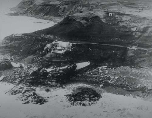 The Scotch Cap lighthouse on Alaska's Unimak Island was destroyed by a tsunami in 1946. (Courtesy U.S. Coast Guard & NOAA - National Geophysical Data Center)
Undeterred, Fryer went back to the drawing board to try to prove his landslide theory. He poured over mountains of data and re-read reports about the tsunami. Two pieces of evidence are critical. One is the record kept by the Scotch Cap light keepers who logged the time the first big wave hit. That wave struck 48 minutes after the earthquake occurred. Using the timeline and the presumed speed of the tsunami, Fryer calculated the location of the landslide. He now knows that calculation was wrong. Fryer said, "The error was not the 48 minutes. The error was my interpretation of that 48 minutes. We know how fast a tsunami travels if the wave height is only a small fraction of the total water depth. It turns out that when the wave height is a large fraction of the water depth, the crest travels faster than the trough. Eventually it forms a bore, a vertical wall of water." Fryer now believes the wave that hit Scotch Cap was a fast-moving bore that barreled across the Aleutian's shallow coastal waters. The second critical piece of information comes from records kept by the former Aleut community on Sanak Island, east of Unimak Island. Those records indicate the wave struck the island 30 minutes after the quake. For that to occur, Fryer now says the tsunami must have raced across the sea at nearly 140 miles an hour, twice the speed normally thought of for a wave in shallow water. Armed with a new understanding of the historical record, Fryer believes the landslide probably occurred about 60 miles further east of where he looked last summer, in an area just southwest of Sanak Island. Instead, Okal offers his own explanation. He says the unusually long and slow earthquake produced a massive tsunami that raced across the open sea toward Hawaii. The temblor also unleashed a small undersea landslide somewhere near Unimak Island that in turn spawned a second, localized tsunami powerful enough to wipe out the lighthouse. Gerard Fryer hopes to visit the site where he now thinks a massive undersea landslide occurred. We may all have to wait until then to know for sure just what happened all those decades ago. But Fryer says the wait will be worth it if it means having a better understanding of just how tsunamis are generated. He says while scientists agree that undersea landslides can generate local tsunamis, most don't believe they can spawn huge, killer waves capable of crossing an entire ocean. Fryer said, "We have a tsunami warning system that is predicated on the idea that the source of tsunamis is earthquakes. If a significant number of tsunamis in Hawaii, say, are generated by landslides on the other side of the Pacific, that's something that wasn't known before."
Listen to this story on RealAudio This story is courtesy of Arctic Science Journeys. Arctic Science Journeys is a radio service highlighting science, culture, and the environment of the circumpolar north. Produced by the Alaska Sea Grant College Program and the University of Alaska Fairbanks.
|
||