
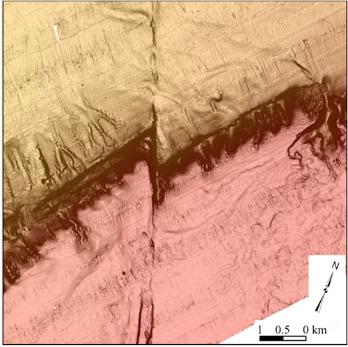
Seabed expression of the Queen Charlotte Fault in southeastern Alaska. |
“Data from this research are being used to refine the seismic hazard for southeastern Alaska, as well as to develop geologic models that can be applied to similar plate boundaries around the globe,” said Peter Haeussler, USGS Geologist at the Alaska Science Center and a co-author of the data publications.
Like the San Andreas fault, the Queen Charlotte-Fairweather Fault separates the Pacific tectonic plate from the North American plate. Both are right-lateral strike-slip faults (one side moves to the right relative to the other), and both can generate large, dangerous earthquakes.
“We can think of this fault system as the San Andreas of the north,” said USGS Research Geophysicist Danny Brothers, a lead author of the publications. “It appears to be the fastest moving continent-ocean strike-slip fault in the world.” Speedy faults like the Queen Charlotte can trigger earthquakes and tsunamis more frequently than slower faults.
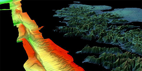
A computed-generated image showing the bathymetry of the Queen Charlotte Fault and the elevation of mountains in the nearshore area, using bathymetry and lidar data. |
The USGS and numerous collaborators began mapping the fault in detail in 2015. Since then, three different research vessels have collected more than 16,000 square kilometers of new high-resolution multibeam sonar on both the U.S. and Canadian portions of the fault, in depths ranging from 0 to 2,271 meters. In addition to multibeam sonar, their tools included seismic-reflection surveys that use sound to reveal rock layers beneath the seafloor, piston cores that bring up the top several meters of ocean sediment for further scrutiny, and cameras with powerful lights dragged just above the seabed.
In subsequent research expeditions (two in 2016, one in summer 2017, and another in fall 2017), additional data were collected along the underwater Queen Charlotte Fault. The 2016 research expeditions used Lidar and trenching to gather data on the Fairweather fault, the terrestrial portion of this tectonic system in the nearly roadless Glacier Bay National Park in southeast Alaska.
From the beginning, this project has been a joint effort between Canada and the United States. “Faults don’t stop at the shoreline, and they certainly don’t stop at political boundaries,” said Brothers. “We are fortunate to have a strong partnership with Natural Resources Canada’s Geological Survey of Canada, so that we can examine the fault system in its entirety." Additional partners include EXPRESS (Expanding Pacific Research and Exploration of Submerged Systems), University of Calgary, NOAA Hydrographic Services Division, Sitka Sound Science Center, Alaska Department of Fish and Game, and the National Science Foundation.
Related:
Earthquake Hazards in Southeastern Alaska - Over the last 100 years, the Queen Charlotte-Fairweather fault system has produced large-magnitude earthquakes affecting both Canada and the U.S. To fill in missing details about its offshore location and structure, USGS uses sophisticated techniques to truly understand the fault’s hazard potential. - Read more...
List of Data Publications:
Edited by Mary Kauffman, SitNews
Source of News:
Coastal and Marine Hazards and Resources Program
USGS
www.usgs.govPacific Coastal and Marine Science Center
Woods Hole Coastal and Marine Science Center
Alaska Science Center
Representations of fact and opinions in comments posted are solely those of the individual posters and do not represent the opinions of Sitnews.
Send a letter to the editor@sitnews.us
SitNews ©2023
Stories In The News
Ketchikan, Alaska
Articles & photographs that appear in SitNews are considered protected by copyright and may not be reprinted without written permission from and payment of any required fees to the proper freelance writers and subscription services.
E-mail your news & photos to editor@sitnews.us
Photographers choosing to submit photographs for publication to SitNews are in doing so granting their permission for publication and for archiving. SitNews does not sell photographs. All requests for purchasing a photograph will be emailed to the photographer.