EPIC SOUTHEAST ALASKA SHOREZONE COASTAL MAPPING PROJECT COMPLETED
January 17, 2012
NOAA and other members of the ShoreZone Partnership will make a presentation on the recently completed seven-year project January 19 at the 2012 Alaska Marine Science Symposium in Anchorage.
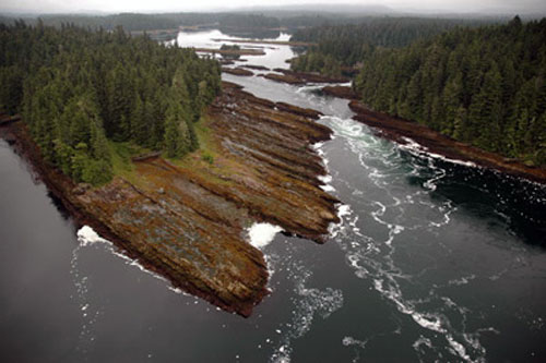
Tidal rapids in a lagoon near Angoon, Alaska.
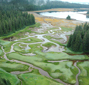
The project also marks the first time Southeast Alaska's entire coast has been mapped at the lowest tides of each year. "One of the amazing aspects of this project is that the entire shoreline is imaged at low tide, which took a lot of planning," said Dr. John Harper, project manager for Coastal & Ocean Resources, a partner and the primary contractor for the project. "Only some of the images on Google Earth have been collected at low tide. So this is the first time we are able to see the entire intertidal zone." The Alexander Archipelago or Alaska's panhandle is known for its myriad of well over 1,000 islands and represents almost 40 percent of Alaska's coastline. Imagery was collected during 20 separate summer surveys since 2004. The Alaska data and imagery—including over one million video captures and 178,000 high-resolution photographs—are all available online at NOAA Fisheries' Alaska Regional Office website: http://alaskafisheries.noaa.gov/shorezone/ One of the most exciting aspects of the project is the wide range of ways the images and information can be used, according to Jon Kurland, assistant regional administrator for Habitat Conservation for NOAA Fisheries Alaska Regional Office.
"The Alaska ShoreZone data is available on our website in a format that's easy for the public to use" said Kurland. "It's a great resource for regulatory agencies, land owners, developers, oil spill responders, and others to help identify important coastal habitat features and even sensitive habitats such as salt marsh or eelgrass." "What we're finding is that the ShoreZone program is an indispensable conservation tool for coastal Alaska," said Norman Cohen of The Nature Conservancy. "The state's network of oil spill responders thanked us for giving them a new way to protect coastal fish habitat. Engineers building projects along Alaska coastlines use ShoreZone to avoid sensitive habitats." "Kayakers use it to plan tours, non-government organizations use it in their global conservation planning and government and private industry are routinely using it to develop better spill response plans," added Harper. "The data have even been used to predict where invasive species are most likely to show up. It always surprises us how ShoreZone information is used." Sometimes, the imagery is just nice to look at. Harper recalled a comment made by elder Mike Jackson from the small Southeast Alaska village of Kake during one 2009 survey, as Jackson viewed the aerial imagery of Admiralty Island where he had learned to hunt and fish: "I feel like an eagle while watching this." Members of the public can also view some of the most beautiful coastal photos captured during the Alaska ShoreZone program, which will be on display during the Alaska Marine Science Symposium, January 16-20 at the Hotel Captain Cook in Anchorage. The exhibit, titled "Coastal Impressions: A Photographic Journey along Alaska's Gulf Coast," is being hosted by the Cook Inlet Regional Citizens Advisory Council (CIRCAC). The Southeast Alaska ShoreZone initiative received the Coastal America Spirit Award in 2009 in recognition of an "outstanding partnership." Supporting agencies and partners include: NOAA Fisheries Alaska Regional Office and Auke Bay Laboratories, The Nature Conservancy, USDA Forest Service, Alaska Department of Natural Resources, Alaska Department of Fish and Game, Southeast Alaska Petroleum Response Organization (SEAPRO), Ocean Fund (Carnival Cruises), Coastal & Ocean Resources Inc., and Archipelago Marine Research Ltd.
On the Web:
Source of News:
E-mail your news &
photos to editor@sitnews.us
|
|||