 Alaska's crumbling northern
coastline
Alaska's crumbling northern
coastline
By NED ROZELL
January 14, 2009
Wednesday
Esook Trading Post appears as a few dots on United States Geological
Survey maps of northern Alaska, but if you travel to its location
today, you'll be standing in the ocean. The sea has eaten the
former structures and graves that made up the turn-of-the-last-century
place of business about 120 miles west of Prudhoe Bay. The demise
of Esook Trading Post is a story somewhat typical of the northern
coast of Alaska, where the sea is consuming land at rates among
the highest in the world.
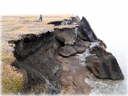 Christopher Arp of
the USGS Alaska Science Center stands on part
Christopher Arp of
the USGS Alaska Science Center stands on part
of Alaska's eroding northern coast, between Lonely and Cape Halkett.
Photo by Benjamin Jones.
Benjamin Jones went to look for Esook Trading Post not too long
ago. A research geographer with the USGS Alaska Science Center
in Anchorage, Jones knew of the trading post and was curious
to see if anything was left of the site, which once included
five buildings and several graves with wooden markers.
Looking back over historical photos and other records, Jones
found that another researcher had calculated that the trading
post site had lost more than 1,200 feet to the Beaufort Sea from
1949 to 1981, when the last structure was about 60 feet from
the ocean. Based on erosion rates, the last building probably
disappeared in the mid-to-late 1980s, Jones said, and he didn't
see any more grave markers during a snowmachine trip there in
spring 2008.
The moral of this story? Don't build too close to the coastline
of northern Alaska, where thawing ground makes for some of the
most dynamic real estate on the planet. In a recent paper published
in the journal Geophysical Research Letters, Jones and his colleagues
wrote that on a section of Beaufort Sea coastline north of Teshekpuk
Lake, erosion rates increased from about 20 feet per year during
the 1950s to the late 1970s to about 40 feet per year during
the last five years. They found the changes by comparing different
eras of aerial photography of the area. Reasons they gave for
the possible increase of disappearing coast included declining
sea ice, warmer ocean temperatures, rising sea level, and weakening
of permafrost bluffs.
"Taken together, these factors may be leading to a new regime
of ocean-land interactions that are repositioning and reshaping
the Arctic coastline," Jones and his coauthors wrote.
Though the acceleration of erosion rates at some areas of the
northern Alaska coast may be due to forces related to a warming
climate, the disappearance of the coastline has been happening
for thousands of years, Jones said. Erosion of coastlines is
natural, and northern Alaska is especially interesting because
ice lenses and frozen ground cement much of the coast. And because
the summers are so short there.
"One interesting thing to think about is that all of this
erosion occurs in three to four months," Jones said.
While few people in the world will ever see Alaska's northern
coast, it is the site of some of America's largest known deposits
of fossil fuels. Rapid erosion since 2002 brought the sea to
an oil test well drilled in the late 1970s, and the ocean will
soon meet another test well near Drew Point, Jones wrote. It
seems that anyone with plans to place structures in the area
would do well not to ignore the impressive speed at which portions
of the northern coast can become northern ocean.
This column is provided
as a public service by the Geophysical Institute,
University of Alaska Fairbanks, in cooperation with the UAF research
community.
Ned Rozell is a science writer at the institute.
E-mail your news &
photos to editor@sitnews.us
Publish A Letter in SitNews Read Letters/Opinions
Contact the Editor
SitNews
©2009
Stories In The News
Ketchikan, Alaska
|